Aouste
Aouste is a commune in the Ardennes department in the Grand Est region of northern France.
Aouste | |
|---|---|
 | |
 Coat of arms | |
Location of Aouste 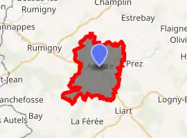
| |
 Aouste  Aouste | |
| Coordinates: 49°47′54″N 4°18′59″E | |
| Country | France |
| Region | Grand Est |
| Department | Ardennes |
| Arrondissement | Charleville-Mézières |
| Canton | Signy-l'Abbaye |
| Intercommunality | Thiérache Ardennaise |
| Government | |
| • Mayor (2020–2026) | Xavier Coffart |
| Area 1 | 12.83 km2 (4.95 sq mi) |
| Population (2017-01-01)[1] | 207 |
| • Density | 16/km2 (42/sq mi) |
| Time zone | UTC+01:00 (CET) |
| • Summer (DST) | UTC+02:00 (CEST) |
| INSEE/Postal code | 08016 /08290 |
| Elevation | 187–289 m (614–948 ft) (avg. 205 m or 673 ft) |
| 1 French Land Register data, which excludes lakes, ponds, glaciers > 1 km2 (0.386 sq mi or 247 acres) and river estuaries. | |
The inhabitants of the commune are known as Aoustiens or Aoustiennes[2]
Geography
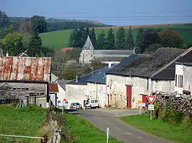
Aouste is located some 35 km south-east of Hirson and 40 km west by north-west of Charleville-Mézières. Access is by the D36 road from La Férée in the south passing through the village then continuing east to Prez. The D27 road also comes from Rumigny in the west passing through the commune south of the village and continuing to Marlemont in the south-east. A railway from Hirson to Charleville-Mezieres passes through the commune with a station at Liart just outside the commune to the south-east. Apart from the village the commune is mostly farmland with a few patches of forest.
The Aube river passes through the commune from the east and flows through the village before continuing west to join the Ton at Hannappes. The Ruisseau de Laval d'Estrebay flows from the north forming part of the northern border to join the Aube on the western border. There is also the Ruisseau du Moulin Veron which flows from the south joining the Aube near the village. The Ruisseau de Gandlu flows from the south-east joining the Aube in the village.[3]
Neighbouring communes and villages
Places adjacent to Aouste | |
|---|---|
Heraldry
Arms of Aouste |
Blazon: Argent, a lion of Sable, in chief a bar embattled-counter-embattled of Gules, the whole bordure in Vert. |
Administration
List of Successive Mayors[4]
| From | To | Name | Party | Position |
|---|---|---|---|---|
| 1995 | 2020 | Xavier Coffart | UMP | General Councillor (1998-2004) |
(Not all data is known)
Demography
In 2017 the commune had 207 inhabitants.
|
| ||||||||||||||||||||||||||||||||||||||||||||||||||||||||||||||||||||||||||||||||||||||||||||||||||||||||||||
| Source: EHESS[5] and INSEE[6] | |||||||||||||||||||||||||||||||||||||||||||||||||||||||||||||||||||||||||||||||||||||||||||||||||||||||||||||
Sites and monuments

.
The fortified Church of Saint-Rémi (15th century) is registered as an historical monument.![]() [7]
[7]
Aouste Picture Gallery
_lavoir.JPG.webp) Aouste Lavoir
Aouste Lavoir_mairie.JPG.webp) Aouste Town Hall
Aouste Town Hall_Monument_aux_morts.JPG.webp) The War Memorial
The War Memorial_chapelle_Ste_Philom%C3%A8ne.JPG.webp) Chapel of Saint Philomene
Chapel of Saint Philomene_city_limit_sign.JPG.webp) Entrance to the village
Entrance to the village_Paysage_avec_croix_de_chemin.JPG.webp) Wayside Cross at Aouste
Wayside Cross at Aouste
See also
External links
- Aouste on the National Geographic Institute website (in French)
- Aouste on Lion1906
- Aouste on Géoportail, National Geographic Institute (IGN) website (in French)
- Aoufte on the 1750 Cassini Map
References
- "Populations légales 2017". INSEE. Retrieved 6 January 2020.
- Inhabitants of Ardennes (in French)
- Google Maps
- List of Mayors of France
- Des villages de Cassini aux communes d'aujourd'hui: Commune data sheet Aouste, EHESS. (in French)
- Population en historique depuis 1968, INSEE
- Ministry of Culture, Mérimée PA00078332 Church of Saint-Rémi (in French)
| Wikimedia Commons has media related to Aouste. |