Auvillers-les-Forges
Auvillers-les-Forges is a commune in the Ardennes department in the Grand Est region of northern France.
Auvillers-les-Forges | |
|---|---|
_Ancienne_gare_au_hameau_Mon_Id%C3%A9e_(cropped).JPG.webp) The old railway station | |
 Coat of arms | |
Location of Auvillers-les-Forges 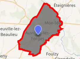
| |
 Auvillers-les-Forges  Auvillers-les-Forges | |
| Coordinates: 49°51′49″N 4°21′31″E | |
| Country | France |
| Region | Grand Est |
| Department | Ardennes |
| Arrondissement | Charleville-Mézières |
| Canton | Rocroi |
| Intercommunality | CC Ardennes Thiérache |
| Government | |
| • Mayor (2014-2020) | Miguel Leroy |
| Area 1 | 8.19 km2 (3.16 sq mi) |
| Population (2017-01-01)[1] | 877 |
| • Density | 110/km2 (280/sq mi) |
| Time zone | UTC+01:00 (CET) |
| • Summer (DST) | UTC+02:00 (CEST) |
| INSEE/Postal code | 08037 /08260 |
| Elevation | 235–296 m (771–971 ft) (avg. 290 m or 950 ft) |
| 1 French Land Register data, which excludes lakes, ponds, glaciers > 1 km2 (0.386 sq mi or 247 acres) and river estuaries. | |
Geography
Auvillers-les-Forges is located some 27 km west by north-west of Charleville-Mézières and 22 km east by south-east of Hirson. Access to the commune is by the European route E44 from Maubert-Fontaine in the east which passes through the north of the commune intersecting the D877 in the commune and continuing to Hirson in the west. Access to the village is by the D877 from Éteignières in the north which passes through the length of the commune and the village and continues south to Champlin. The D20 goes south-east from the village to Girondelle. Apart from the village there is the hamlet of Le Chateau-Vert north-east of the village. There is a large forest in the north of the commune (the Bois d'Auviller-les-Forges) but the rest of the commune is farmland.[2]
The Sormonne River flows through the commune from west to east just north of the village and continues east to join the Meuse at Charleville-Mézières. The Ruisseau de Saint-Rémy rises just west of the village and flows south-west to join the Orvaux east of Fontenelle.[2]
Neighbouring communes and villages
Places adjacent to Auvillers-les-Forges | ||||||||||
|---|---|---|---|---|---|---|---|---|---|---|
| ||||||||||
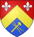
Heraldry
Arms of Auvillers-les-Forges |
Blazon: Party per chevron, Gules with two fleurs-de-lis of Argent first, Azure a forge tongs of Or and a hammer the same saltirewise, tongs to dexter surmounted by hammer to sinister second; over all a chevron of Or. |
Administration
_Mairie.JPG.webp)
_Les_Halles.JPG.webp)
List of successive mayors[3][4]
| From | To | Name | Party | Position |
|---|---|---|---|---|
| 1891 | 1919 | Gustave Tanton | ||
| 1919 | 1923 | Camille Decq | ||
| 1923 | 1929 | Maurice Tourolle | ||
| 1929 | 1944 | Paul Martin | ||
| 1944 | 1945 | Edgard Faucon | ||
| 1945 | 1947 | Georges Pacaux | ||
| 1947 | 1959 | Julien Lagneaux | ||
| 1959 | 1965 | Paul Hottiaux | ||
| 1965 | 1980 | Abdon Lemaire | ||
| 1980 | 1983 | Pierre Gillot | ||
| 1983 | 1995 | Martial Guilain | ||
| 1995 | 1998 | Bruno Coniglio | ||
| 1998 | 2014 | Daniel Schanen | ||
| 2014 | 2020 | Miguel Leroy |
(Not all data is known)
Demography
In 2017 the commune had 877 inhabitants.
|
| ||||||||||||||||||||||||||||||||||||||||||||||||||||||||||||||||||||||||||||||||||||||||||||||||||||||||||||
| Source: EHESS[5] and INSEE[6] | |||||||||||||||||||||||||||||||||||||||||||||||||||||||||||||||||||||||||||||||||||||||||||||||||||||||||||||
_Monument_aux_morts_1914-1918.JPG.webp)
_%C3%89glise.JPG.webp)
See also
References
- "Populations légales 2017". INSEE. Retrieved 6 January 2020.
- "Auvillers-les-Forges". Auvillers-les-Forges. Retrieved 2018-11-05.
- List of Mayors of France (in French)
- "List of Mayors". www.francegenweb.org (in French). Retrieved 2018-11-05.
- Des villages de Cassini aux communes d'aujourd'hui: Commune data sheet Auvillers-les-Forges, EHESS. (in French)
- Population en historique depuis 1968, INSEE
External links
- Auvillers-les-Forges on Lion1906
- Auvillers-les-Forges on Géoportail, National Geographic Institute (IGN) website (in French)
- Auvillers-les-Forges on the 1750 Cassini Map
| Wikimedia Commons has media related to Auvillers-les-Forges. |
| Authority control |
|---|