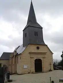
Les Ayvelles
Les Ayvelles is a commune in the Ardennes department in the Grand Est region of northern France.
Les Ayvelles | |
|---|---|
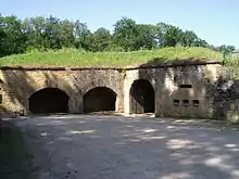
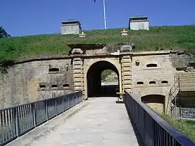 The Fort of Ayvelles | |
 Coat of arms | |
Location of Les Ayvelles 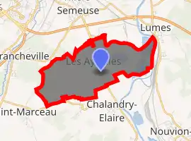
| |
 Les Ayvelles  Les Ayvelles | |
| Coordinates: 49°43′20″N 4°45′28″E | |
| Country | France |
| Region | Grand Est |
| Department | Ardennes |
| Arrondissement | Charleville-Mézières |
| Canton | Nouvion-sur-Meuse |
| Intercommunality | CA Ardenne Métropole |
| Government | |
| • Mayor (2014–2020) | Philippe Lebreton |
| Area 1 | 5.45 km2 (2.10 sq mi) |
| Population (2017-01-01)[1] | 897 |
| • Density | 160/km2 (430/sq mi) |
| Time zone | UTC+01:00 (CET) |
| • Summer (DST) | UTC+02:00 (CEST) |
| INSEE/Postal code | 08040 /08000 |
| Elevation | 143–210 m (469–689 ft) (avg. 155 m or 509 ft) |
| 1 French Land Register data, which excludes lakes, ponds, glaciers > 1 km2 (0.386 sq mi or 247 acres) and river estuaries. | |
The inhabitants of the commune are known both as Ayvelliens or Ayvelliennes as well as Ayvellois or Ayvelloises.[2]
Geography
Les Ayvelles is located just 5 km south-east of Charleville-Mézières. Access to the commune is by road D764 from Villers-Semeuse in the north which passes through the centre of the commune and the village and continues to Flize in the south. The commune has large reservoirs in the east and a forest in the west (the Bois des Ayvelles) with the rest of the commune farmland.[3]
The Meuse river forms the eastern border of the commune as it flows north to Belgium. The Ruisseau du Pierge rises in the west of the commune and flows east to join the Meuse.[3]
Neighbouring communes and villages[3]
Places adjacent to Les Ayvelles | |
|---|---|
Heraldry
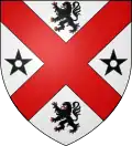
Arms of Les Ayvelles |
Blazon: Argent, a saltire Gules cantoned with, in chief and in base a lion Sable tongued and armed Gules, to dexter and sinister a mullet Sable pierced. |
Administration
List of Successive Mayors[4]
| From | To | Name | Party | Position |
|---|---|---|---|---|
| 1995 | 2008 | Robert Binet | ||
| 2008 | 2014 | Jacques Bragantini | ||
| 2014 | 2020 | Philippe Lebreton |
(Not all data is known)
Demography
In 2017 the commune had 897 inhabitants.
|
| ||||||||||||||||||||||||||||||||||||||||||||||||||||||||||||||||||||||||||||||||||||||||||||||||||||||||||||
| Source: EHESS[5] and INSEE[6] | |||||||||||||||||||||||||||||||||||||||||||||||||||||||||||||||||||||||||||||||||||||||||||||||||||||||||||||
Culture and heritage
Civil heritage
- The Fort and Battery of Ayvelles. The Fort can be visited by appointment.
See also
External links
- Les Ayvelles on the old IGN website (in French)
- Les Ayvelles on Lion1906
- Les Ayvelles on Géoportail, National Geographic Institute (IGN) website (in French)
- les G-des-Ayvelles on the 1750 Cassini Map
References
- "Populations légales 2017". INSEE. Retrieved 6 January 2020.
- Inhabitants of Ardennes (in French)
- Google Maps
- List of Mayors of France (in French)
- Données Cassini, EHESS
- Population en historique depuis 1968, INSEE
- Ministry of Culture, Palissy PM08000042 Tombstone of Priest Ponce Guérin (in French)

- Ministry of Culture, Palissy PM08000041 Baptismal font (in French)
- Ministry of Culture, Palissy PM08000675 Chalice with Paten (in French)
| Wikimedia Commons has media related to Les Ayvelles. |