Arnicourt
Arnicourt is a commune in the Ardennes department in the Grand Est region of northern France.
Arnicourt | |
|---|---|
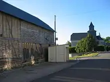
_city_limit_sign.JPG.webp) Entrance to the village | |
Location of Arnicourt 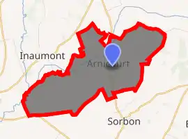
| |
 Arnicourt  Arnicourt | |
| Coordinates: 49°33′20″N 4°21′00″E | |
| Country | France |
| Region | Grand Est |
| Department | Ardennes |
| Arrondissement | Rethel |
| Canton | Rethel |
| Intercommunality | CC Pays Rethélois |
| Government | |
| • Mayor (2014–2020) | Alain Samyn |
| Area 1 | 8.33 km2 (3.22 sq mi) |
| Population (2017-01-01)[1] | 157 |
| • Density | 19/km2 (49/sq mi) |
| Time zone | UTC+01:00 (CET) |
| • Summer (DST) | UTC+02:00 (CEST) |
| INSEE/Postal code | 08021 /08300 |
| Elevation | 72–147 m (236–482 ft) (avg. 106 m or 348 ft) |
| 1 French Land Register data, which excludes lakes, ponds, glaciers > 1 km2 (0.386 sq mi or 247 acres) and river estuaries. | |
Geography
Arnicourt is located some 6 km north by north-west of Rethel and 8 km south-west of Novion-Porcien. Access to the commune is by the D10 road from Sorbon in the south passing through the commune and the village continuing to Sery in the north. The commune is entirely farmland with a small patch of forest in the north.[2]
The Plumion river flows through the north of the commune from north to south-west joining the Rayee on the south-western border. The Rayee continues south-west forming a small part of the south-western border.[2]
Neighbouring communes and villages
Places adjacent to Arnicourt | |
|---|---|
Administration
_monument_aux_morts.JPG.webp)
War Memorial
Rue Arnicourt
List of Successive Mayors[3]
| From | To | Name | Party | Position |
|---|---|---|---|---|
| 2001 | 2020 | Alain Samyn |
(Not all data is known)
Demography
In 2017 the commune had 157 inhabitants.
|
| ||||||||||||||||||||||||||||||||||||||||||||||||||||||||||||||||||||||||||||||||||||||||||||||||||||||||||||
| Source: EHESS[4] and INSEE[5] | |||||||||||||||||||||||||||||||||||||||||||||||||||||||||||||||||||||||||||||||||||||||||||||||||||||||||||||
Sites and monuments
- The Church of Saint-Médard.
- The Chateau of Arnicourt (18th century) is registered as an historical monument.
 [6]
[6]
_%C3%A9glise.JPG.webp) Church of Saint-Médard
Church of Saint-Médard_croix.JPG.webp) Cross
Cross Chateau of Arnicourt
Notable people linked to the commune
- Gérard Darrieu (1925–2004), actor.
See also
References
- "Populations légales 2017". INSEE. Retrieved 6 January 2020.
- Google Maps
- List of Mayors of France (in French)
- Données Cassini, EHESS
- Population en historique depuis 1968, INSEE
- Ministry of Culture, Mérimée PA08000006 Church (in French)
External links
- Arnicourt on the National Geographic Institute website (in French)
- Arnicourt on Lion1906
- Arnicourt on Géoportail, National Geographic Institute (IGN) website (in French)
- Arnicourt on the 1750 Cassini Map
| Wikimedia Commons has media related to Arnicourt. |
This article is issued from Wikipedia. The text is licensed under Creative Commons - Attribution - Sharealike. Additional terms may apply for the media files.