Autry
Autry is a commune in the Ardennes department in the Grand Est region of north-eastern France.
Autry | |
|---|---|
 The Lavoir (Public laundry) in Autry | |
.svg.png.webp) Coat of arms | |
Location of Autry 
| |
 Autry  Autry | |
| Coordinates: 49°16′09″N 4°50′16″E | |
| Country | France |
| Region | Grand Est |
| Department | Ardennes |
| Arrondissement | Vouziers |
| Canton | Attigny |
| Intercommunality | CC Argonne Ardennaise |
| Government | |
| • Mayor (2014-2020) | Pascal Boxebeld |
| Area 1 | 16.34 km2 (6.31 sq mi) |
| Population (2017-01-01)[1] | 117 |
| • Density | 7.2/km2 (19/sq mi) |
| Time zone | UTC+01:00 (CET) |
| • Summer (DST) | UTC+02:00 (CEST) |
| INSEE/Postal code | 08036 /08250 |
| Elevation | 110–168 m (361–551 ft) (avg. 121 m or 397 ft) |
| 1 French Land Register data, which excludes lakes, ponds, glaciers > 1 km2 (0.386 sq mi or 247 acres) and river estuaries. | |
The inhabitants of the commune are known as Autryens or Autryennes.[2]
Geography

Autry is located some 50 km east of Reims and 25 km north by north-west of Sainte-Menehould. The southern border of the commune is the departmental boundary between Ardennes and Marne. Access to the commune is by road D21 from Challerange in the north-west which passes through the centre of the commune and the village and continues to Binarville in the south-east after changing to the D63 at the departmental border. The D218 goes west from the village to Bouconville and the D41 goes north-east to Lançon. Apart from the village there is the hamlet of La Gare in the west. Large areas of the commune are forested, especially in the west, and there is a large fish farm in the east. The rest of the commune is farmland.[3]
The Aisne river forms part of the south-eastern border of the commune as it flows north then west to the village then north again as it continues its journey to join the Oise at Compiègne. The Dormoise flows from the south-west to join the Aisne in the commune. The Remy Galere rises on the northern border and flows east to join the Aisne forming part of the northern border.[3]
Neighbouring communes and villages
Places adjacent to Autry | |
|---|---|
Heraldry
.svg.png.webp) Arms of Autry |
Blazon: Bendy of Or and Gules. |
Administration

List of Successive Mayors[4]
| From | To | Name | Party | Position |
|---|---|---|---|---|
| 1995 | 2014 | Jean-Pierre Boure | ||
| 2014 | 2020 | Pascal Boxebeld |
(Not all data is known)
Demography
In 2017 the commune had 117 inhabitants.
|
| ||||||||||||||||||||||||||||||||||||||||||||||||||||||||||||||||||||||||||||||||||||||||||||||||||||||||||||
| Source: EHESS[5] and INSEE[6] | |||||||||||||||||||||||||||||||||||||||||||||||||||||||||||||||||||||||||||||||||||||||||||||||||||||||||||||
Culture and heritage
Civil heritage
The commune has one structure that is registered as an historical monument:
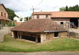
- A Flour Mill (20th century)
 [7]
[7]
- Another site of interest
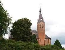
- Around the church in the village there are traces of a medieval fortification system.[8]
 Inside the Lavoir
 Inside the Lavoir
 The village and the church
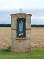 A Shrine
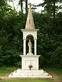 Chapel of Mary
 The Chapel of Saint Lambert
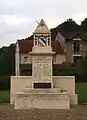 The War Memorial
Notable people linked to the commune
- Louis Marie Alphonse Depuiset (1822-1886), Entomologist.
See also
References
- "Populations légales 2017". INSEE. Retrieved 6 January 2020.
- Inhabitants of (in French)
- Google Maps
- List of Mayors of France (in French)
- Données Cassini, EHESS
- Population en historique depuis 1968, INSEE
- Ministry of Culture, Mérimée IA08000319 Flour Mill (in French)
- The discovery of medieval sites in North Argonne, published by Daniel Hochedez in the Horizons d'Argonne review, No. 88, June 2011, p. 9-10 (in French)
External links
- Autry on the old IGN website (in French)
- Autry on Lion1906
- Autry on Géoportail, National Geographic Institute (IGN) website (in French)
- Autry on the 1750 Cassini Map
| Wikimedia Commons has media related to Autry. |
| Authority control |
|
|---|