Authe
Authe is a commune in the Ardennes department in the Grand Est region of northern France.
Authe | |
|---|---|
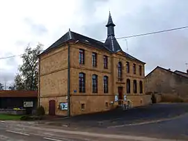 Town hall | |
 Coat of arms | |
Location of Authe 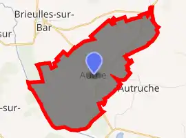
| |
 Authe  Authe | |
| Coordinates: 49°27′36″N 4°52′47″E | |
| Country | France |
| Region | Grand Est |
| Department | Ardennes |
| Arrondissement | Vouziers |
| Canton | Vouziers |
| Intercommunality | CC Argonne Ardennaise |
| Government | |
| • Mayor (2014-2020) | Sylvie Lefort |
| Area 1 | 9.47 km2 (3.66 sq mi) |
| Population (2017-01-01)[1] | 90 |
| • Density | 9.5/km2 (25/sq mi) |
| Time zone | UTC+01:00 (CET) |
| • Summer (DST) | UTC+02:00 (CEST) |
| INSEE/Postal code | 08033 /08240 |
| Elevation | 164–225 m (538–738 ft) (avg. 172 m or 564 ft) |
| 1 French Land Register data, which excludes lakes, ponds, glaciers > 1 km2 (0.386 sq mi or 247 acres) and river estuaries. | |
The inhabitants of the commune are known as Authois or Authoises.[2]
Geography
Authe is located some 45 km east by south-east of Rethel and 20 km north-east of Vouziers. Access to the commune is by road D12 from Brieulles-sur-Bar in the north which passes through the centre of the commune and the village and continues south to join the D947 south of the commune. The commune consists entirely of farmland.[3]
The Bar river forms the south-western border of the commune as it flows north-west to follow the Canal des Ardennes to join the Meuse near Vrigne-Meuse. The Ruisseau de Saint-Pierremont flows from the north-east of the commune past the village and joins the Bar on the south-western border of the commune.[3]
Neighbouring communes and villages
Places adjacent to Authe | |
|---|---|
Heraldry
Arms of Authe |
Blazon: Party per pale Vert and Gules a wolf's head cabossed of Argent debruised by the division, in chief Sable charged with three fleurs-de-lis of Argent. |
Administration
List of Successive Mayors[4]
| From | To | Name | Party | Position |
|---|---|---|---|---|
| 2001 | 2020 | Sylvie Lefort |
(Not all data is known)
Demography
In 2017 the commune had 90 inhabitants.
|
| ||||||||||||||||||||||||||||||||||||||||||||||||||||||||||||||||||||||||||||||||||||||||||||||||||||||||||||
| Source: EHESS[5] and INSEE[6] | |||||||||||||||||||||||||||||||||||||||||||||||||||||||||||||||||||||||||||||||||||||||||||||||||||||||||||||
Culture and heritage
Religious heritage
The commune has one religious building registered as an historical monument:
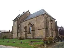
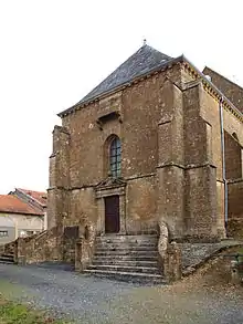
- The Church of Saint-Martin (14th century)
 [7]
[7]
See also
References
- "Populations légales 2017". INSEE. Retrieved 6 January 2020.
- Inhabitants of Ardennes (in French)
- Google Maps
- List of Mayors of France (in French)
- Données Cassini, EHESS
- Population en historique depuis 1968, INSEE
- Ministry of Culture, Mérimée PA00078336 Church of Saint-Martin (in French)

External links
- Authe on Lion1906
- Authe on Géoportail, National Geographic Institute (IGN) website (in French)
- Authe on the 1750 Cassini Map
| Wikimedia Commons has media related to Authe. |