Rocroi
Rocroi is a commune in the Ardennes department in northern France.
Rocroi | |
|---|---|
 A general view of Rocroi | |
.svg.png.webp) Coat of arms | |
Location of Rocroi 
| |
 Rocroi  Rocroi | |
| Coordinates: 49°55′34″N 4°31′20″E | |
| Country | France |
| Region | Grand Est |
| Department | Ardennes |
| Arrondissement | Charleville-Mézières |
| Canton | Rocroi |
| Government | |
| • Mayor (2008–2014) | Michel Sobanska |
| Area 1 | 50.41 km2 (19.46 sq mi) |
| Population (2017-01-01)[1] | 2,330 |
| • Density | 46/km2 (120/sq mi) |
| Time zone | UTC+01:00 (CET) |
| • Summer (DST) | UTC+02:00 (CEST) |
| INSEE/Postal code | 08367 /08230 |
| 1 French Land Register data, which excludes lakes, ponds, glaciers > 1 km2 (0.386 sq mi or 247 acres) and river estuaries. | |
The central area is a notable surviving example of a Star Fort.
Population
|
|
History
Rocroi was fortified by Francis I of France and expanded by Henry II of France. Because of its strategic location in the north of France it changed hands a number of times during wars. It is best known for the Battle of Rocroi in 1643. In the 1670s the fortifications were re-modelled by the French engineer Vauban.[2]
In 1815, two months after the Battle of Waterloo, the town was taken by Prussian and British forces (on 16 August).
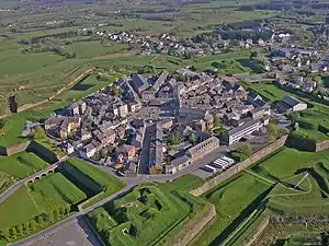
Rocroi seen from the air shows its defensive structure
References
- "Populations légales 2017". INSEE. Retrieved 6 January 2020.
- http://www.fortified-places.com/rocroi.html
External links
| Wikimedia Commons has media related to Rocroi. |
| Authority control |
|---|
This article is issued from Wikipedia. The text is licensed under Creative Commons - Attribution - Sharealike. Additional terms may apply for the media files.