Bar-lès-Buzancy
Bar-lès-Buzancy is a commune in the Ardennes department and Grand Est region of north-eastern France.[2]
Bar-lès-Buzancy | |
|---|---|
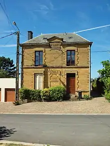
 The village centre and church | |
Location of Bar-lès-Buzancy 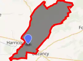
| |
 Bar-lès-Buzancy  Bar-lès-Buzancy | |
| Coordinates: 49°26′02″N 4°56′32″E | |
| Country | France |
| Region | Grand Est |
| Department | Ardennes |
| Arrondissement | Vouziers |
| Canton | Vouziers |
| Intercommunality | Argonne Ardennaise |
| Government | |
| • Mayor (2014–2020) | Francis Potron |
| Area 1 | 9.4 km2 (3.6 sq mi) |
| Population (2017-01-01)[1] | 125 |
| • Density | 13/km2 (34/sq mi) |
| Time zone | UTC+01:00 (CET) |
| • Summer (DST) | UTC+02:00 (CEST) |
| INSEE/Postal code | 08049 /08240 |
| Elevation | 166–305 m (545–1,001 ft) (avg. 182 m or 597 ft) |
| 1 French Land Register data, which excludes lakes, ponds, glaciers > 1 km2 (0.386 sq mi or 247 acres) and river estuaries. | |
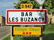
The commune has been awarded two flowers by the National Council of Towns and Villages in Bloom in the Competition of cities and villages in Bloom.[3] (Their sign says three but the official website says two).
Geography
Bar-lès-Buzancy is located some 20 km east by north-east of Vouziers and 25 km west by south-west of Stenay. Access to the commune is by the D947 road from Buzancy in the south-east which passes through the south of the commune and the village and continues west to Harricourt. The D6 goes north from the D947 forming the western border of the commune and continuing north to Sommauthe. The commune is mostly farmland with some forest in the north.[4][5]
The Ruisseau du Moulin rises in the north of the commune and forms part of the northern border before flowing south through the commune and the village and continuing south to join the Canal des Arches near Briquenay. La Hideuse stream forms the southern border of the commune as it flows south-west to join the Canal de Thenorgues.[4]
Neighbouring communes and villages[4] | ||||||||||
|---|---|---|---|---|---|---|---|---|---|---|
| ||||||||||
Toponymy
Bar comes from a Gallic word and perhaps even older (pre-Gallic) meaning "summit" or "height".
History
Bar-lès-Buzancy appears as Bar on the 1750 Cassini Map[6] and the same on the 1790 version.[7]
From 1828-1871 the commune was merged with Harricourt to form the commune of Bar-et-Harricourt. In October 1952 two Merovingian skeletons were discovered during the excavation phase of construction of a house.
Administration
| From | To | Name | Party | Position |
|---|---|---|---|---|
| 1965 | 2001 | Jean Potron | ||
| 2001 | 2008 | Michel Percebois | ||
| 2008 | 2020 | Francis Potron |
(Not all data is known)
Demography
In 2017 the commune had 125 inhabitants. The population data given in the table and graph below for the period 1831-1866 refer to the former commune of Bar-et-Harricourt.
|
| ||||||||||||||||||||||||||||||||||||||||||||||||||||||||||||||||||||||||||||||||||||||||||||||||||||||||||||
| Source: EHESS[9] and INSEE[10] | |||||||||||||||||||||||||||||||||||||||||||||||||||||||||||||||||||||||||||||||||||||||||||||||||||||||||||||
See also
References
- "Populations légales 2017". INSEE. Retrieved 6 January 2020.
- Bar-lès-Buzancy on Lion1906
- Competition for Towns and Villages in Bloom website Archived December 10, 2014, at the Wayback Machine (in French)
- Bar-lès-Buzancy on Google Maps
- Bar-lès-Buzancy on the Géoportail from National Geographic Institute (IGN) website (in French)
- Bar on the 1750 Cassini Map
- Bar on the 1790 Cassini Map
- List of Mayors of France (in French)
- Des villages de Cassini aux communes d'aujourd'hui: Commune data sheet Bar-lès-Buzancy, EHESS. (in French)
- Population en historique depuis 1968, INSEE
| Wikimedia Commons has media related to Bar-lès-Buzancy. |
| Authority control |
|---|