Monthermé
Monthermé is a commune in the Ardennes department in northern France.
Monthermé | |
|---|---|
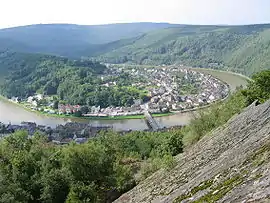 A general view of Monthermé | |
.svg.png.webp) Coat of arms | |
Location of Monthermé 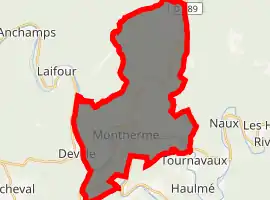
| |
 Monthermé  Monthermé | |
| Coordinates: 49°53′11″N 4°43′56″E | |
| Country | France |
| Region | Grand Est |
| Department | Ardennes |
| Arrondissement | Charleville-Mézières |
| Canton | Bogny-sur-Meuse |
| Government | |
| • Mayor (2008–2014) | Alain Bernard |
| Area 1 | 32.33 km2 (12.48 sq mi) |
| Population (2017-01-01)[1] | 2,335 |
| • Density | 72/km2 (190/sq mi) |
| Time zone | UTC+01:00 (CET) |
| • Summer (DST) | UTC+02:00 (CEST) |
| INSEE/Postal code | 08302 /08800 |
| 1 French Land Register data, which excludes lakes, ponds, glaciers > 1 km2 (0.386 sq mi or 247 acres) and river estuaries. | |
Population
|
|
See also
References
- "Populations légales 2017". INSEE. Retrieved 6 January 2020.
| Wikimedia Commons has media related to Monthermé. |
| Authority control |
|---|
This article is issued from Wikipedia. The text is licensed under Creative Commons - Attribution - Sharealike. Additional terms may apply for the media files.