Arronnes
Arronnes (Occitan, Arona) is a commune in the Allier department in the Auvergne-Rhône-Alpes region of central France.
Arronnes | |
|---|---|
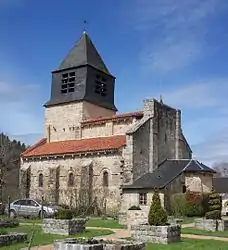 Church of St-Léger at Arronnes | |
.svg.png.webp) Coat of arms | |
Location of Arronnes 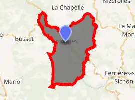
| |
 Arronnes  Arronnes | |
| Coordinates: 46°03′32″N 3°34′10″E | |
| Country | France |
| Region | Auvergne-Rhône-Alpes |
| Department | Allier |
| Arrondissement | Vichy |
| Canton | Lapalisse |
| Intercommunality | Vichy Communauté |
| Government | |
| • Mayor (2020–2026) | François Szypula |
| Area 1 | 26 km2 (10 sq mi) |
| Population (2017-01-01)[1] | 374 |
| • Density | 14/km2 (37/sq mi) |
| Time zone | UTC+01:00 (CET) |
| • Summer (DST) | UTC+02:00 (CEST) |
| INSEE/Postal code | 03008 /03250 |
| Elevation | 330–597 m (1,083–1,959 ft) (avg. 300 m or 980 ft) |
| 1 French Land Register data, which excludes lakes, ponds, glaciers > 1 km2 (0.386 sq mi or 247 acres) and river estuaries. | |
The inhabitants of the commune are known as Arronnais or Arronnaises.[2]
Geography
Arronnes is located some 18 kilometres (11 mi) south-east of Vichy and 6 kilometres (3.7 mi) west by south-west of Le Mayet-de-Montagne. Access to the commune is by the D995 road from Cusset in the north-west passing through the heart of the commune and the village and continuing south-east to Ferrières-sur-Sichon. Apart from the village there are the hamlets of Les Fours, Doyat, Les Barlets, and Les Etangs in the south of the commune. There are substantial forests spread over the commune occupying about 60% of the land area with the balance farmland.[3]
The Sichon river flows from the south-east to the north-west of the commune joined by its tributary the Vareille at the village and continuing north-west to join the Allier in Vichy.[3]
Neighbouring communes and villages
Places adjacent to Arronnes | |
|---|---|
Toponymy
First named in 1282: Arona from the pre-Celtic ar ("stream" or "water") and the Gallic onna meaning river.[4]
Heraldry
Arms of Arronnes |
Blazon: Or, a pal wavy of Azure between in chief a Phrygian helmet of Gules, to dexter a crozier of Sable, to sinister a key the same. |
Administration
List of Successive Mayors[5]
| From | To | Name | Party | Position |
|---|---|---|---|---|
| 2001 | Present | François Szypula[6][7] | UDI | Former General Councillor of the canton of Le Mayet-de-Montagne (2004–2015) |
(Not all data is known)
Population
| Year | Pop. | ±% |
|---|---|---|
| 2006 | 362 | — |
| 2007 | 359 | −0.8% |
| 2008 | 354 | −1.4% |
| 2009 | 357 | +0.8% |
| 2010 | 361 | +1.1% |
| 2011 | 364 | +0.8% |
| 2012 | 364 | +0.0% |
| 2013 | 372 | +2.2% |
| 2014 | 373 | +0.3% |
| 2015 | 375 | +0.5% |
| 2016 | 377 | +0.5% |
Distribution of Age Groups
Percentage Distribution of Age Groups in Arronnes and Allier Department in 2017
| Arronnes | Allier | |||
|---|---|---|---|---|
| Age Range | Men | Women | Men | Women |
| 0 to 14 Years | 13.4 | 16.4 | 16.1 | 14.5 |
| 15 to 29 Years | 16.1 | 11.8 | 15.5 | 12.8 |
| 30 to 44 Years | 11.4 | 14.9 | 16.4 | 15.6 |
| 45 to 59 Years | 28.9 | 31.9 | 21.1 | 20.1 |
| 60 to 74 Years | 19.5 | 11.4 | 20.2 | 20.9 |
| 75 to 89 Years | 10.6 | 13.1 | 9.7 | 13.5 |
| 90 Years+ | 0.0 | 0.6 | 1.0 | 2.6 |
Sites and monuments
- The Church of Saint-Léger (11th century).
 is registered as an historical monument.[10] Built in granite, it once belonged to a Benedictine priory and the monks welcomed pilgrims who crossed the Bourbonnais mountains. In the church is a Bronze Bell from 1520 which is registered as a historical object.
 [11]
[11] - A Peasant's House is located in a former farmhouse from the early 19th century.
See also
External links
- Arronnes on the National Geographic Institute website (in French)
- Arronnes on Lion1906
- Arronnes on Géoportail, National Geographic Institute (IGN) website (in French)
- Aronne on the 1750 Cassini Map
Notes and references
Notes
References
- "Populations légales 2017". INSEE. Retrieved 6 January 2020.
- Arronnes (03250): public services, habitants.fr, SARL Patagos (in French)
- Google Maps
- Bonin, Marcel (2006). Les noms de lieux en Bourbonnais [Place names in Bourbonnais] (in French). p. 17. ISBN 9782844944009.
- List of Mayors of France (in French)
- Re-elected in 2014: "Liste nominative des communes de l'Allier (avec maire, arrondissement et canton)" [Nominative list of communes of Allier (with mayor, arrondissement and canton)] (PDF). Association of Mayors and Presidents of Communities of Allier. 1 April 2015. Archived from the original (PDF) on 18 May 2015. Retrieved 13 May 2015.
- "Liste nominative des communes de l'Allier" [Nominative list of communes of Allier] (PDF). maires-allier.fr (in French). Association of Mayors and Presidents of Communities of Allier. 8 July 2020. p. 1. Retrieved 29 July 2020.
- Évolution et structure de la population en 2017: Commune d'Arronnes (03008)
- Évolution et structure de la population en 2017: Département de l'Allier (03)
- Ministry of Culture, Mérimée PA00092974 Church of Saint-Léger (in French)
- Ministry of Culture, Palissy PM03000014 Bronze Bell (in French)
| Wikimedia Commons has media related to Arronnes. |