Barberier
Barberier is a commune in the Allier department in the Auvergne-Rhône-Alpes region of central France.[2]
Barberier | |
|---|---|
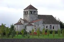 The old Church of Saint André | |
Location of Barberier 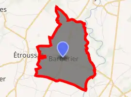
| |
 Barberier  Barberier | |
| Coordinates: 46°13′08″N 3°14′48″E | |
| Country | France |
| Region | Auvergne-Rhône-Alpes |
| Department | Allier |
| Arrondissement | Moulins |
| Canton | Gannat |
| Intercommunality | Pays Saint-Pourcinois |
| Government | |
| • Mayor (2020–2026) | Philippe Château |
| Area 1 | 8.08 km2 (3.12 sq mi) |
| Population (2017-01-01)[1] | 143 |
| • Density | 18/km2 (46/sq mi) |
| Time zone | UTC+01:00 (CET) |
| • Summer (DST) | UTC+02:00 (CEST) |
| INSEE/Postal code | 03016 /03140 |
| Elevation | 254–290 m (833–951 ft) (avg. 269 m or 883 ft) |
| 1 French Land Register data, which excludes lakes, ponds, glaciers > 1 km2 (0.386 sq mi or 247 acres) and river estuaries. | |
Geography
Barberier is located some 17 km (11 mi) north-west of Vichy and some 17 km (11 mi) north by north-east of Gannat. Access to the commune is by the D36 road from Étroussat in the west which passes through the centre of the commune and the village and continues east to join the D2009 east of the commune. The D183 comes from Bayet in the north and also passes through the centre of the commune, intersecting the D36 at the village, continuing south to join the D66 south of the commune. Apart from the village there are the hamlets of Les Varennes in the south, La Grange Neuve in the east, and Bompré in the north.[3][4]
The Sioule river flows north along the south-eastern border of the commune and continues north to join the Allier north-east of Contigny.[3]
Neighbouring communes and villages[3] | |
|---|---|
History
Barberier appears as Barbrier on the 1750 Cassini Map[5] and the same the 1790 version.[6]
Administration
| From | To | Name | Party | Position |
|---|---|---|---|---|
| 2001 | 2014 | Claude Pornin | ||
| 2014 | Current | Philippe Château[8][9] |
(Not all data is known)
Demography
In 2017 the commune had 143 inhabitants.[10]
|
| ||||||||||||||||||||||||||||||||||||||||||||||||||||||||||||||||||||||||||||||||||||||||||||||||||||||||||||||||||
| Source: EHESS[11] and INSEE[10] | |||||||||||||||||||||||||||||||||||||||||||||||||||||||||||||||||||||||||||||||||||||||||||||||||||||||||||||||||||
Sites and monuments
There are two sites in the commune that are registered as historical monuments:
See also
Bibliography
- Raymond d'Azémar, Étroussat, Barberier. Municipal Chronicles from the Revolution to today, Montluçon, 1983 (in French)
References
- "Populations légales 2017". INSEE. Retrieved 6 January 2020.
- Barberier on Lion1906
- Barberier on Google Maps
- Barberier on the Géoportail from IGN (in French)
- Barbrier on the 1750 Cassini Map
- Barbrier on the 1790 Cassini Map
- List of Mayors of France (in French)
- "Liste nominative des communes de l'Allier (avec maire, arrondissement et canton)" [Nominative list of communes of Allier (with mayor, arrondissement and canton)] (PDF). Association of Mayors and Presidents of Communities of Allier. 1 April 2015. Archived from the original (PDF) on 18 May 2015. Retrieved 13 May 2015.
- "Liste nominative des communes de l'Allier" [Nominative list of communes of Allier] (PDF). maires-allier.fr (in French). Association of Mayors and Presidents of Communities of Allier. 8 July 2020. p. 1. Retrieved 31 July 2020.
- Population en historique depuis 1968, INSEE
- Données Cassini, EHESS
- Ministry of Culture, Mérimée PA00093381 Château of Bompré (in French)
- Ministry of Culture, Mérimée PA00092982 Church of Saint André (in French)

| Wikimedia Commons has media related to Barberier. |