Avrilly, Allier
Avrilly is a commune of the Allier department in the Auvergne-Rhône-Alpes region of central France.
Avrilly | |
|---|---|
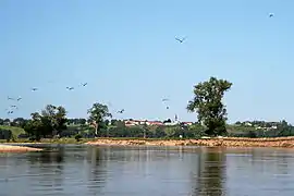 The Loire at Avrilly | |
Location of Avrilly 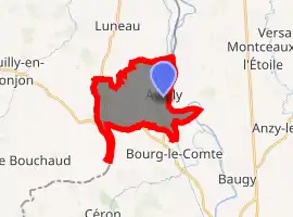
| |
 Avrilly  Avrilly | |
| Coordinates: 46°20′03″N 3°58′54″E | |
| Country | France |
| Region | Auvergne-Rhône-Alpes |
| Department | Allier |
| Arrondissement | Vichy |
| Canton | Dompierre-sur-Besbre |
| Intercommunality | CC Entr'Allier Besbre Loire |
| Government | |
| • Mayor (2020–2026) | Solène Carignant |
| Area 1 | 11.48 km2 (4.43 sq mi) |
| Population (2017-01-01)[1] | 135 |
| • Density | 12/km2 (30/sq mi) |
| Time zone | UTC+01:00 (CET) |
| • Summer (DST) | UTC+02:00 (CEST) |
| INSEE/Postal code | 03014 /03130 |
| Elevation | 234–312 m (768–1,024 ft) (avg. 280 m or 920 ft) |
| 1 French Land Register data, which excludes lakes, ponds, glaciers > 1 km2 (0.386 sq mi or 247 acres) and river estuaries. | |
The inhabitants of the commune are known as Avrillois or Avrilloises.[2]
Geography
Avrilly is located 45 km (28 mi) north-east of Vichy and 10 km (6.2 mi) north-west of Marcigny. The eastern border of the commune is also the departmental border between Allier and Saône-et-Loire. Access to the commune is by road D989 from Neuilly-en-Donjon in the west which passes through the south of the commune and continues to Bourg-le-Comte. The D210 branches from the D169 in the north and passes down the eastern side of the commune through the village and continues south, changing to the D229 at the border, to join the D989 north-west of Bourg-le-Comte. The D265 connects the village to the D989 in the west of the commune. The D212 branches from the D989 in the west of the commune and goes north to Luneau. Apart from the village there are the hamlets of Les Raflots and Les Simonins in the west. There are some small scattered forests in the commune but it is mostly farmland.[3]
The Loire river flows along the eastern border of the commune approximately forming the border as it flows north to join the Atlantic Ocean at Saint-Nazaire. The Canal de Roanne à Digoin also flows inside the eastern border parallel to the Loire. A number of streams rise in the commune and flow east to join the Loire forming many ponds.[3]
Neighbouring communes and villages
Places adjacent to Avrilly, Allier | |
|---|---|
History
In a papal bull dated April 1164 Pope Alexander III, from his refugee in France, confirmed the Abbey of Saint-Martin of Autun as patron of the Church of Avrilly.[4] The Church was burned down on 15 August 1592. The monks also owned Rejus, a hamlet in Saint-Martin du Lac between the church and Champceau in the parish of Anzy-le-Duc.[5]
Administration
List of Successive Mayors[6]
| From | To | Name | Party | Position |
|---|---|---|---|---|
| 2001 | 2008 | Marie Edith Perreaud | ||
| 2008 | 2020 | Claudette Delorme[7] | ||
| 2020 | Current | Solène Carignant[8] |
(Not all data is known)
Demography
In 2017 the commune had 135 inhabitants.[9]
|
| ||||||||||||||||||||||||||||||||||||||||||||||||||||||||||||||||||||||||||||||||||||||||||||||||||||||||||||||||||
| Source: EHESS[10] and INSEE[9] | |||||||||||||||||||||||||||||||||||||||||||||||||||||||||||||||||||||||||||||||||||||||||||||||||||||||||||||||||||
Sites and Monuments
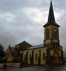
The Church contains a Tabernacle (17th century)![]() which is registered as an historical object.[11]
which is registered as an historical object.[11]
Avrilly Picture Gallery
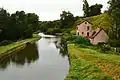 The Canal de Roanne à Digoin at Avrilly
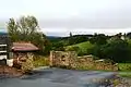 Avrilly Landscape
See also
External links
- Avrilly on the old IGN website (in French)
- Avrilly official website (in French)
- Community of communes Le Donjon Val Libre website (in French)
- Avrilly, Allier on Lion1906
- Avrilly on Géoportail, National Geographic Institute (IGN) website (in French)
- Avrilly on the 1750 Cassini Map
References
- "Populations légales 2017". INSEE. Retrieved 6 January 2020.
- "Avrilly (03130): Public services". Habitants.fr (in French). SARL Patagos. Retrieved 24 January 2016.
- Google Maps
- Cartulary of the Abbey of Saint-Martin of Autun: Chart No. XVIII. (in French)
- Jean Gregaine: Journal of a bourgeois from Marcilly, during the League in Brionnais (1589-1596), MSE, Vol. 38, 1910, BNF-Gallica. (in French)
- List of Mayors of France (in French)
- Re-elected in 2014: "Liste nominative des communes de l'Allier (avec maire, arrondissement et canton)" [Nominative list of communes of Allier (with mayor, arrondissement and canton)] (PDF). Association of Mayors and Presidents of Communities of Allier. 1 April 2015. Archived from the original (PDF) on 18 May 2015. Retrieved 13 May 2015.
- "Liste nominative des communes de l'Allier" [Nominative list of communes of Allier] (PDF). maires-allier.fr (in French). Association of Mayors and Presidents of Communities of Allier. 8 July 2020. p. 1. Retrieved 29 July 2020.
- Population en historique depuis 1968, INSEE
- Données Cassini, EHESS
- Ministry of Culture, Palissy PM03000020 Church (in French)
| Wikimedia Commons has media related to Avrilly. |