Domérat
Domérat is a commune in the Allier department in central France. In 2016, the municipality had 8,819 inhabitants, down 2.3% compared to 2011.
Domérat | |
|---|---|
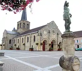 The church in Domérat | |
.svg.png.webp) Coat of arms | |
Location of Domérat 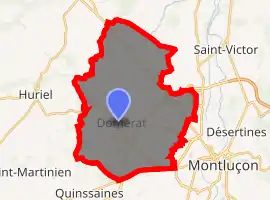
| |
 Domérat  Domérat | |
| Coordinates: 46°21′40″N 2°32′07″E | |
| Country | France |
| Region | Auvergne-Rhône-Alpes |
| Department | Allier |
| Arrondissement | Montluçon |
| Canton | Montluçon-1 |
| Intercommunality | Montluçon |
| Government | |
| • Mayor (2020–2026) | Pascale Lescurat[1] |
| Area 1 | 35.54 km2 (13.72 sq mi) |
| Population (2017-01-01)[2] | 8,780 |
| • Density | 250/km2 (640/sq mi) |
| Time zone | UTC+01:00 (CET) |
| • Summer (DST) | UTC+02:00 (CEST) |
| INSEE/Postal code | 03101 /03410 |
| Elevation | 197–376 m (646–1,234 ft) (avg. 243 m or 797 ft) |
| 1 French Land Register data, which excludes lakes, ponds, glaciers > 1 km2 (0.386 sq mi or 247 acres) and river estuaries. | |
Population
|
|
See also
References
- "Pascale Lescurat élue maire" [Pascale Lescurat elected mayor]. La Montagne (in French). 24 May 2020. Retrieved 24 May 2020.
- "Populations légales 2017". INSEE. Retrieved 6 January 2020.
| Wikimedia Commons has media related to Domérat. |
This article is issued from Wikipedia. The text is licensed under Creative Commons - Attribution - Sharealike. Additional terms may apply for the media files.