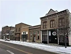
Belt, Montana
Belt is a town in Cascade County, Montana, United States. The population was 597 according to the 2010 census.[4] It is part of the Great Falls, Montana metropolitan area.
Belt, Montana | |
|---|---|
 | |
 Location of Belt, Montana | |
| Coordinates: 47°23′9″N 110°55′36″W | |
| Country | United States |
| State | Montana |
| County | Cascade |
| Area | |
| • Total | 0.34 sq mi (0.88 km2) |
| • Land | 0.34 sq mi (0.88 km2) |
| • Water | 0.00 sq mi (0.00 km2) |
| Elevation | 3,510 ft (1,070 m) |
| Population | |
| • Total | 597 |
| • Estimate (2019)[3] | 564 |
| • Density | 1,668.64/sq mi (644.51/km2) |
| Time zone | UTC-7 (Mountain (MST)) |
| • Summer (DST) | UTC-6 (MDT) |
| ZIP code | 59412 |
| Area code(s) | 406 |
| FIPS code | 30-05275 |
| GNIS feature ID | 0779676 |
| Website | www |
Belt was home to Montana's first coal mine.[5] It supplied fuel to Fort Benton.[6] The post office opened on February 2, 1885, with Eugene Clingan as postmaster.[6]
Geography
Belt is located at 47°23′9″N 110°55′36″W (47.385935, -110.926587).[7] According to the United States Census Bureau, the town has a total area of 0.35 square miles (0.91 km2), all land.[8]
The town was named for Belt Butte, a nearby mountain which has a dark layer resembling a belt.
Climate
According to the Köppen Climate Classification system, Belt has a semi-arid climate, abbreviated "BSk" on climate maps.[9]
Demographics
| Historical population | |||
|---|---|---|---|
| Census | Pop. | %± | |
| 1910 | 1,158 | — | |
| 1920 | 967 | −16.5% | |
| 1930 | 810 | −16.2% | |
| 1940 | 744 | −8.1% | |
| 1950 | 702 | −5.6% | |
| 1960 | 757 | 7.8% | |
| 1970 | 656 | −13.3% | |
| 1980 | 825 | 25.8% | |
| 1990 | 571 | −30.8% | |
| 2000 | 633 | 10.9% | |
| 2010 | 597 | −5.7% | |
| 2019 (est.) | 564 | [3] | −5.5% |
| U.S. Decennial Census[10] | |||
2010 census
As of the census[2] of 2010, there were 597 people, 261 households, and 159 families living in the town. The population density was 1,705.7 inhabitants per square mile (658.6/km2). There were 295 housing units at an average density of 842.9 per square mile (325.4/km2). The racial makeup of the town was 95.5% White, 1.7% Native American, 0.5% Asian, 0.2% from other races, and 2.2% from two or more races. Hispanic or Latino of any race were 1.0% of the population.
There were 261 households, of which 29.1% had children under the age of 18 living with them, 47.5% were married couples living together, 10.7% had a female householder with no husband present, 2.7% had a male householder with no wife present, and 39.1% were non-families. 33.0% of all households were made up of individuals, and 13.7% had someone living alone who was 65 years of age or older. The average household size was 2.29 and the average family size was 2.92.
The median age in the town was 43.4 years. 23.8% of residents were under the age of 18; 7.6% were between the ages of 18 and 24; 20.4% were from 25 to 44; 30.4% were from 45 to 64; and 18.1% were 65 years of age or older. The gender makeup of the town was 50.1% male and 49.9% female.
2000 census
As of the census[11] of 2000, there were 666 people, 273 households, and 168 families living in the city. The population density was 1,877.0 people per square mile (718.8/km2). There were 295 housing units at an average density of 874.7 per square mile (335.0/km2). The racial makeup of the city was 94.94% White, 1.42% African American, 1.42% Native American, 0.32% Pacific Islander, 0.16% from other races, and 1.74% from two or more races. Hispanic or Latino of any race were 1.11% of the population.
There were 273 households, out of which 28.9% had children under the age of 18 living with them, 49.1% were married couples living together, 8.8% had a female householder with no husband present, and 38.1% were non-families. 35.9% of all households were made up of individuals, and 18.7% had someone living alone who was 65 years of age or older. The average household size was 2.32 and the average family size was 3.03.
In the city, the population was spread out, with 26.5% under the age of 18, 7.4% from 18 to 24, 25.9% from 25 to 44, 24.2% from 45 to 64, and 16.0% who were 65 years of age or older. The median age was 39 years. For every 100 females, there were 90.7 males. For every 100 females age 18 and over, there were 83.8 males.
The median income for a household in the city was $25,469, and the median income for a family was $30,104. Males had a median income of $21,477 versus $20,192 for females. The per capita income for the city was $14,970. About 10.2% of families and 12.9% of the population were below the poverty line, including 19.8% of those under age 18 and 16.5% of those age 65 or over.
Notable people
- James R. Browning, judge on the United States Court of Appeals for the Ninth Circuit
- Matt Maki, Finnish-born master carpenter and builder of the 1890s
- Jack Myllymaki, musician
See also
- List of cities and towns in Montana
References
- "2019 U.S. Gazetteer Files". United States Census Bureau. Retrieved July 26, 2020.
- "U.S. Census website". United States Census Bureau. Retrieved 2012-12-18.
- "Population and Housing Unit Estimates". United States Census Bureau. May 24, 2020. Retrieved May 27, 2020.
- "Profile of General Population and Housing Characteristics: 2010 Demographic Profile Data (DP-1): Belt town, Montana". United States Census Bureau. Retrieved January 26, 2012.
- "Montana Place Names Companion". Montana Historical Society. Retrieved 22 July 2017.
- Carkeek Cheney, Roberta (1983). Names on the Face of Montana. Missoula, Montana: Mountain Press Publishing Company. p. 5. ISBN 0-87842-150-5.
- "US Gazetteer files: 2010, 2000, and 1990". United States Census Bureau. 2011-02-12. Retrieved 2011-04-23.
- "US Gazetteer files 2010". United States Census Bureau. Archived from the original on 2012-07-02. Retrieved 2012-12-18.
- Climate Summary for Belt, Montana
- "Census of Population and Housing". Census.gov. Retrieved June 4, 2015.
- "U.S. Census website". United States Census Bureau. Retrieved 2008-01-31.
External links
Municipalities and communities of Cascade County, Montana, United States | ||
|---|---|---|
| City | 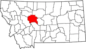 Cascade County map | |
| Towns | ||
| CDPs | ||
| Unincorporated community | ||
| Indian reservation | ||
| ||
| Communities of the Great Falls Metro area | |||||||
|---|---|---|---|---|---|---|---|
| Geography | |||||||
| History | |||||||
| Education |
| ||||||
| Media |
| ||||||
| Services |
| ||||||
| Sports |
| ||||||
| Breweries |
| ||||||
| Notable people | |||||||
| |||||||