Beni-Chougrane
The Beni-Chougrane Range (Arabic: جبال بني شقران, French: Monts des Beni-Chougrane) is a mountain range in the northwest of Algeria, part of the Atlas Mountain System.
| Beni-Chougrane Range | |
|---|---|
| جبال بني شقران | |
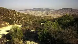 View of the range from Sig, 1973 | |
| Highest point | |
| Elevation | 932 m (3,058 ft) |
| Coordinates | 35°30′0″N 0°13′0″E [1] |
| Dimensions | |
| Area | 1,618 km2 (625 sq mi) |
| Geography | |
 Beni-Chougrane Range | |
| Parent range | Tell Atlas |
| Geology | |
| Orogeny | Alpine orogeny |
| Type of rock | Limestone, clay |
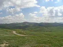
View from Mohammadia, 2007.
Geography
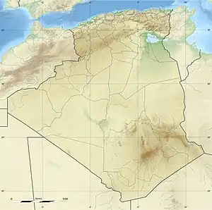
The mountains of Beni-Chougrane belong to the Tell Atlas chain located between the Plain of Habra-Sig in the north and the Plain of Ghriss in the south.[2] They are characterized by a Mediterranean climate and a semi-arid terrain, which promotes erosion. The range's average altitude is 700 m and rises to 932 m in the vicinity of El Bordj.
Several dams are located in the mountain range. as well as rich plains and major wadis such as El Hammam and Fergoug. The area is currently undergoing reforestation.[3] The total area is 1618 km2 or 32% of the area of Mascara wilaya.
See also
References
- Google Earth
- Monographie de la wilaya de Mascara, sur le site de la Chambre Algérienne de Commerce et d'Industrie Archived December 11, 2011, at the Wayback Machine
- Marc Côte, Guide d'Algérie : paysages et patrimoine, Média-Plus, 1996, 319 p. (ISBN 9961-922-00-X), p. 69
| Tell Atlas |
|
|---|---|
| Saharan Atlas |
|
| Saharan massifs | |
| Peaks |
|
This article is issued from Wikipedia. The text is licensed under Creative Commons - Attribution - Sharealike. Additional terms may apply for the media files.
