DeKalb County, Indiana
DeKalb County is a county in the U.S. state of Indiana. As of the 2010 United States Census, the population was 42,223.[1] The county seat is Auburn.[2]
DeKalb County | |
|---|---|
 | |
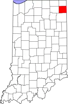 Location within the U.S. state of Indiana | |
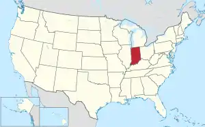 Indiana's location within the U.S. | |
| Coordinates: 41°22′01″N 85°03′32″W | |
| Country | |
| State | |
| Founded | 7 February 1835 (authorized) 1837 (organized) |
| Named for | Johann, Baron de Kalb |
| Seat | Auburn |
| Largest city | Auburn |
| Area | |
| • Total | 363.85 sq mi (942.4 km2) |
| • Land | 362.82 sq mi (939.7 km2) |
| • Water | 1.03 sq mi (2.7 km2) 0.28%% |
| Population | |
| • Estimate (2018) | 43,226 |
| • Density | 119.1/sq mi (46.0/km2) |
| Time zone | UTC−5 (Eastern) |
| • Summer (DST) | UTC−4 (EDT) |
| Congressional district | 3rd |
| Website | DeKalb County Government |
| Indiana county number 17 | |
History
On 7 February 1835, the Indiana State Legislature passed an omnibus bill[3] that authorized the creation of thirteen counties in northeast Indiana on previously unorganized land (including the recent Wabash New Purchase).[4] The organization of the county's government commenced in 1837.[5] It was named for General Johann de Kalb, a Continental Army officer from Bavaria, who was killed at the Battle of Camden in South Carolina.[6][7] The first settlers in the future DeKalb County were from New England, settling what was then known as the Northwest Territory. These people were "Yankee" migrants, descended from the English Puritans who settled New England in the colonial era.[8] In the 1870s immigrants from Ireland and Germany began arriving in DeKalb County, in large numbers.[9][10][11]
Geography
DeKalb County lies on the east side of Indiana; its east border abuts the western border of Ohio. Its low, rolling terrain is entirely devoted to agriculture or urban development.[12] Its highest point (1,060 feet/323 meters ASL) is a small rise in the NW portion of the county, 2 miles (3.2 km) west of Fairfield Center.[13] The Saint Joseph River flows southwestward through the SE portion of the county, while the western part of the county is drained by Cedar Creek.
According to the 2010 census, the county has a total area of 363.85 square miles (942.4 km2), of which 362.82 square miles (939.7 km2) (or 99.72%) is land and 1.03 square miles (2.7 km2) (or 0.28%) is water.[14]
Adjacent counties
- LaGrange County - northwest
- Steuben County - north
- Williams County, Ohio - northeast
- Defiance County, Ohio - southeast
- Allen County - south
- Noble County - west
Unincorporated communities
Townships
Major highways
Climate and weather
| Auburn, Indiana | ||||||||||||||||||||||||||||||||||||||||||||||||||||||||||||
|---|---|---|---|---|---|---|---|---|---|---|---|---|---|---|---|---|---|---|---|---|---|---|---|---|---|---|---|---|---|---|---|---|---|---|---|---|---|---|---|---|---|---|---|---|---|---|---|---|---|---|---|---|---|---|---|---|---|---|---|---|
| Climate chart (explanation) | ||||||||||||||||||||||||||||||||||||||||||||||||||||||||||||
| ||||||||||||||||||||||||||||||||||||||||||||||||||||||||||||
| ||||||||||||||||||||||||||||||||||||||||||||||||||||||||||||
In recent years, average temperatures in Auburn have ranged from a low of 17 °F (−8 °C) in January to a high of 84 °F (29 °C) in July, although a record low of −24 °F (−31 °C) was recorded in January 1984 and a record high of 106 °F (41 °C) was recorded in June 1988. Average monthly precipitation ranged from 1.42 inches (36 mm) in February to 4.17 inches (106 mm) in June.[15]
Government
The county government is a constitutional body, granted specific powers by the Constitution of Indiana and the Indiana Code.
County Council: The fiscal branch of the county government; controls spending and revenue collection in the county. Representatives are elected to four-year terms from county districts. They are responsible for setting salaries, the annual budget, and special spending. The council also has limited authority to impose local taxes, in the form of an income and property tax that is subject to state level approval, excise taxes, and service taxes.[16][17]
Board of Commissioners: A three-member board of commissioners combines executive and non-fiscal legislative powers. Commissioners are elected county-wide, in staggered four-year terms. One commissioner serves as president. The commissioners also function as the county drainage board, exercising control over the construction and maintenance of legal drains.[16][17]
Courts: DeKalb County has a Circuit Court (75th Judicial Circuit) and two Superior Courts. By local rule, approved by the Indiana Supreme Court,[18] the jurisdiction of the Circuit Court is currently limited to juvenile and domestic cases. Criminal, civil and domestic cases are heard in the two superior courts. Judges of each court are elected for six-year terms on partisan tickets.
County Officials: The county has other elected offices, including sheriff, coroner, auditor, treasurer, recorder, surveyor, and circuit court clerk. Each officer is elected to a four-year term of four years and oversees a different part of county government. Members elected to county government positions are required to declare a party affiliation and to be residents of the county.[17]
DeKalb County is part of Indiana's 3rd congressional district and in 2008 was represented by Mark Souder in the United States Congress.[19] It is in Indiana Senate districts 13 and 14,[20] and Indiana House of Representatives districts 51, 52 and 85.[21]
| Year | Republican | Democratic | Third parties |
|---|---|---|---|
| 2016 | 71.3% 12,054 | 23.3% 3,942 | 5.4% 906 |
| 2012 | 64.7% 10,587 | 33.1% 5,419 | 2.2% 354 |
| 2008 | 57.0% 9,780 | 41.8% 7,175 | 1.3% 219 |
| 2004 | 68.0% 10,468 | 31.2% 4,810 | 0.8% 125 |
| 2000 | 63.1% 8,701 | 34.7% 4,776 | 2.2% 308 |
| 1996 | 51.4% 6,851 | 36.3% 4,840 | 12.4% 1,648 |
| 1992 | 44.5% 6,682 | 31.0% 4,652 | 24.6% 3,688 |
| 1988 | 65.8% 9,018 | 34.0% 4,657 | 0.3% 41 |
| 1984 | 64.8% 8,769 | 34.1% 4,617 | 1.1% 142 |
| 1980 | 56.5% 7,886 | 35.2% 4,911 | 8.3% 1,153 |
| 1976 | 55.2% 7,860 | 43.2% 6,151 | 1.7% 235 |
| 1972 | 66.4% 8,834 | 32.7% 4,354 | 0.8% 109 |
| 1968 | 56.9% 7,650 | 35.7% 4,790 | 7.4% 998 |
| 1964 | 44.7% 6,210 | 54.4% 7,559 | 0.9% 120 |
| 1960 | 62.7% 8,957 | 36.9% 5,277 | 0.4% 61 |
| 1956 | 66.8% 9,061 | 32.7% 4,435 | 0.6% 79 |
| 1952 | 64.7% 8,713 | 32.3% 4,347 | 3.1% 416 |
| 1948 | 54.9% 6,941 | 43.0% 5,439 | 2.2% 272 |
| 1944 | 60.4% 7,479 | 38.8% 4,810 | 0.8% 98 |
| 1940 | 57.2% 7,676 | 42.4% 5,690 | 0.5% 60 |
| 1936 | 44.9% 5,848 | 53.5% 6,970 | 1.6% 209 |
| 1932 | 43.1% 5,590 | 55.7% 7,235 | 1.2% 156 |
| 1928 | 64.0% 7,373 | 35.4% 4,077 | 0.6% 64 |
| 1924 | 54.6% 6,093 | 37.1% 4,133 | 8.3% 928 |
| 1920 | 56.4% 6,514 | 41.1% 4,750 | 2.6% 296 |
| 1916 | 43.5% 2,898 | 50.7% 3,372 | 5.8% 387 |
| 1912 | 18.1% 1,125 | 44.5% 2,766 | 37.4% 2,320 |
| 1908 | 42.4% 2,991 | 52.2% 3,684 | 5.4% 377 |
| 1904 | 50.0% 3,416 | 41.4% 2,827 | 8.7% 593 |
| 1900 | 46.1% 3,218 | 50.0% 3,488 | 3.9% 273 |
| 1896 | 45.6% 3,137 | 53.4% 3,678 | 1.0% 71 |
| 1892 | 40.0% 2,499 | 44.9% 2,801 | 15.1% 944 |
| 1888 | 46.3% 2,879 | 50.8% 3,160 | 2.9% 182 |
Demographics
| Historical population | |||
|---|---|---|---|
| Census | Pop. | %± | |
| 1840 | 1,968 | — | |
| 1850 | 8,251 | 319.3% | |
| 1860 | 13,880 | 68.2% | |
| 1870 | 17,167 | 23.7% | |
| 1880 | 20,225 | 17.8% | |
| 1890 | 24,307 | 20.2% | |
| 1900 | 25,711 | 5.8% | |
| 1910 | 25,054 | −2.6% | |
| 1920 | 25,600 | 2.2% | |
| 1930 | 24,911 | −2.7% | |
| 1940 | 24,756 | −0.6% | |
| 1950 | 26,023 | 5.1% | |
| 1960 | 28,271 | 8.6% | |
| 1970 | 30,837 | 9.1% | |
| 1980 | 33,606 | 9.0% | |
| 1990 | 35,324 | 5.1% | |
| 2000 | 40,285 | 14.0% | |
| 2010 | 42,223 | 4.8% | |
| 2019 (est.) | 43,475 | [23] | 3.0% |
| US Decennial Census[24] 1790-1960[25] 1900-1990[26] 1990-2000[27] 2010-2014[1] | |||
As of the 2010 United States Census, there were 42,223 people, 15,951 households, and 11,328 families in the county.[28] The population density was 116.4 inhabitants per square mile (44.9/km2). There were 17,558 housing units at an average density of 48.4 per square mile (18.7/km2).[14] The racial makeup of the county was 96.9% white, 0.5% Asian, 0.4% black or African American, 0.2% American Indian, 0.8% from other races, and 1.2% from two or more races. Those of Hispanic or Latino origin made up 2.4% of the population.[28] In terms of ancestry, 36.3% were German, 10.9% were American, 10.8% were Irish, and 9.1% were English.[29]
Of the 15,951 households, 35.2% had children under the age of 18 living with them, 54.8% were married couples living together, 10.5% had a female householder with no husband present, 29.0% were non-families, and 24.3% of all households were made up of individuals. The average household size was 2.61 and the average family size was 3.08. The median age was 38.1 years.[28]
The median income for a household in the county was $47,697 and the median income for a family was $55,280. Males had a median income of $44,880 versus $30,663 for females. The per capita income for the county was $21,779. About 6.7% of families and 9.0% of the population were below the poverty line, including 11.3% of those under age 18 and 6.2% of those age 65 or over.[30]
Education
School districts
Private schools
- Lakewood Park Christian School
- St. Joseph's Catholic School (Garrett)
- Trinity Lutheran Church Preschool
- Zion Lutheran Pre-School (Garrett)
See also
- National Register of Historic Places listings in DeKalb County, Indiana
- The Star, daily newspaper covering DeKalb County
External links
References
- "DeKalb County QuickFacts". US Census Bureau. Archived from the original on July 9, 2011. Retrieved September 17, 2011.
- "Find a County". National Association of Counties. Archived from the original on May 31, 2011. Retrieved June 7, 2011.
- John W Tyndall & OE Lesh, Standard History of Adams and Wells Counties, Indiana. pp. 284-6 (accessed 9 August 2020)
- The counties are Dekalb, Fulton, Jasper, Jay, Kosciusko, Marshall, Newton, Porter, Pulaski, Stark, Steuben, Wells, and Whitley. Newton County was merged with Jasper County in 1839, and was re-authorized as a separate county in 1859.
- "DeKalb County IN". STATS Indiana. Indiana Business Research Center. Retrieved July 13, 2014.
- De Witt Clinton Goodrich & Charles Richard Tuttle (1875). An Illustrated History of the State of Indiana. Indiana: R. S. Peale & Co. p. 555.
- Gannett, Henry (1905). The Origin of Certain Place Names in the United States. Govt. Print. Off. p. 103.
- Yankee Exodus: An Account of Migration from New England by Stewart Holbrook
- Ford, Ira (January 1, 1920). History of Northeast Indiana: LaGrange, Steuben, Noble and DeKalb Counties. Lewis Publishing Co.
- History of DeKalb County IN: Together with Sketches of Its Cities, Villages and Towns ... and Biographies of Representative Citizens : Also a Condensed History of Indiana ... Inter-State Publishing Co. January 1, 1885.
- Co., B. F. Bowen & (January 1, 1914). History of Dekalb County IN : with biographical sketches of representative citizens and genealogical records of old families ... B.F. Bowen & Co.
- DeKalb County IN (Google Maps, accessed 27 July 2020)
- DeKalb County High Point, Indiana (PeakBagger.com, accessed 27 July 2020)
- "Population, Housing Units, Area, and Density: 2010 - County". US Census Bureau. Archived from the original on February 12, 2020. Retrieved July 10, 2015.
- "Monthly Averages for Auburn IN". The Weather Channel. Retrieved January 27, 2011.
- Indiana Code. "Title 36, Article 2, Section 3". IN.gov. Retrieved September 16, 2008.
- Indiana Code. "Title 2, Article 10, Section 2" (PDF). IN.gov. Retrieved September 16, 2008.
- Local Rule 17-AR-1-1, approved March 9, 2007, by the Indiana Supreme Court.
- "US Congressman Mark Souder". US Congress. Archived from the original on October 9, 2008. Retrieved October 8, 2008.
- "Indiana Senate Districts". State of Indiana. Retrieved January 23, 2011.
- "Indiana House Districts". State of Indiana. Retrieved January 23, 2011.
- Leip, David. "Atlas of US Presidential Elections". uselectionatlas.org. Retrieved May 14, 2018.
- "Population and Housing Unit Estimates". Retrieved July 26, 2019.
- "US Decennial Census". US Census Bureau. Retrieved July 10, 2014.
- "Historical Census Browser". University of Virginia Library. Retrieved July 10, 2014.
- "Population of Counties by Decennial Census: 1900 to 1990". US Census Bureau. Retrieved July 10, 2014.
- "Census 2000 PHC-T-4. Ranking Tables for Counties: 1990 and 2000" (PDF). US Census Bureau. Retrieved July 10, 2014.
- "Profile of General Population and Housing Characteristics: 2010 Demographic Profile Data". US Census Bureau. Archived from the original on February 13, 2020. Retrieved July 10, 2015.
- "Selected Social Characteristics in the US – 2006-2010 American Community Survey 5-Year Estimates". US Census Bureau. Archived from the original on February 14, 2020. Retrieved July 10, 2015.
- "Selected Economic Characteristics – 2006-2010 American Community Survey 5-Year Estimates". US Census Bureau. Archived from the original on February 14, 2020. Retrieved July 10, 2015.
Places adjacent to DeKalb County, Indiana | ||||||||||
|---|---|---|---|---|---|---|---|---|---|---|
| ||||||||||
Municipalities and communities of DeKalb County, Indiana, United States | ||
|---|---|---|
| Cities | Map of Indiana highlighting DeKalb County | |
| Towns | ||
| Townships | ||
| Unincorporated communities | ||
| Footnotes | ‡This populated place also has portions in an adjacent county or counties | |
| ||
| Counties | 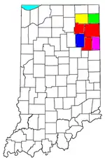 | |
|---|---|---|
| Municipalities with population over 10,000 in 2010 | ||
| Municipalities with population 1,000-10,000 in 2010 | ||
| Municipalities with population under 1,000 in 2010 | ||
| CDPs | ||

| Authority control |
|---|
