Wells County, Indiana
Wells County is a county in the U.S. state of Indiana. As of the 2010 United States Census, the population was 27,636.[1] The county seat (and only incorporated city) is Bluffton.[2]
Wells County | |
|---|---|
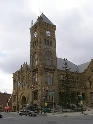 Wells County Courthouse in Bluffton | |
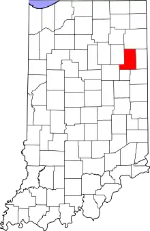 Location within the U.S. state of Indiana | |
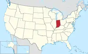 Indiana's location within the U.S. | |
| Coordinates: 40°44′N 85°13′W | |
| Country | |
| State | |
| Founded | 1837 |
| Named for | William A. Wells |
| Seat | Bluffton |
| Largest city | Bluffton |
| Area | |
| • Total | 370.25 sq mi (958.9 km2) |
| • Land | 368.09 sq mi (953.3 km2) |
| • Water | 2.16 sq mi (5.6 km2) 0.58%% |
| Population | |
| • Estimate (2018) | 28,206 |
| • Density | 76.6/sq mi (29.6/km2) |
| Time zone | UTC−5 (Eastern) |
| • Summer (DST) | UTC−4 (EDT) |
| Congressional district | 3rd |
| Website | www |
| Indiana county number 90 | |
Wells County is included in the Fort Wayne Metropolitan Statistical Area and the Fort Wayne–Huntington–Auburn Combined Statistical Area.
History
The future state of Indiana was first regulated by passage of the Northwest Ordinance in 1787. The governing structure created by this act created Wayne County as part of Indiana Territory in 1796. As the Territory's lands began filling with settlers, other counties were organized, and in December 1816 the State of Indiana was admitted to the Union. The state legislature approved (on 7 February 1835) an omnibus bill which authorized the division of portions of Wayne County into thirteen counties.[3] Wells was named for William A. Wells.[4] It was assigned to Allen County for legislative and administrative affairs at first.
On 2 February 1837 an act was passed by the state, authorizing Wells County to be organized independent of Allen County, and specifying 1 May for the date of first meeting. However, that meeting did not take place, so an act dated 20 January 1838 further authorized the meeting of appointed commissioners to decide on a county seat. That vote was completed on 5 March 1838, selecting Bluffton.[5]
Geography
The low rolling hills of Wells County have been deforested and are now completely devoted to agriculture and urban development. The Wabash River flows to the northwest, draining the central and upper part of the county, while the lower part is drained by the Salamonie River, also flowing to the northwest.[6] The highest point on the terrain (935 feet/285 meters ASL) is an isolated rise on the county's south borderline with Jay County, one-half mile (0.8 km) east of the NE corner of Blackford County.[7]
According to the 2010 census, the county has a total area of 370.25 square miles (958.9 km2), of which 368.09 square miles (953.3 km2) (or 99.42%) is land and 2.16 square miles (5.6 km2) (or 0.58%) is water.[8]
Adjacent counties
- Allen County - north
- Adams County - east
- Jay County - southeast
- Blackford County - south
- Grant County - west
- Huntington County - northwest
City and towns
- Bluffton (city/county seat)
- Markle (town; partly in Huntington County)
- Ossian (town)
- Poneto (town - named Worthington from 1871 to 1881)
- Uniondale (town)
- Vera Cruz (town)
- Zanesville (town; partly in Allen County)
Unincorporated communities
Major highways
Climate and weather
| Bluffton, Indiana | ||||||||||||||||||||||||||||||||||||||||||||||||||||||||||||
|---|---|---|---|---|---|---|---|---|---|---|---|---|---|---|---|---|---|---|---|---|---|---|---|---|---|---|---|---|---|---|---|---|---|---|---|---|---|---|---|---|---|---|---|---|---|---|---|---|---|---|---|---|---|---|---|---|---|---|---|---|
| Climate chart (explanation) | ||||||||||||||||||||||||||||||||||||||||||||||||||||||||||||
| ||||||||||||||||||||||||||||||||||||||||||||||||||||||||||||
| ||||||||||||||||||||||||||||||||||||||||||||||||||||||||||||
In recent years, average temperatures in Bluffton have ranged from a low of 16 °F (−9 °C) in January to a high of 84 °F (29 °C) in July, although a record low of −24 °F (−31 °C) was recorded in January 1985 and a record high of 104 °F (40 °C) was recorded in July 1980. Average monthly precipitation ranged from 1.83 inches (46 mm) in February to 4.11 inches (104 mm) in May.[9]
Government
The county government is a constitutional body, and is granted specific powers by the Constitution of Indiana, and by the Indiana Code.
County Council: The legislative branch of the county government; controls spending and revenue collection in the county. Representatives are elected to four-year terms from county districts. They set salaries, the annual budget, and special spending. The council has limited authority to impose local taxes, in the form of an income and property tax that is subject to state level approval, excise taxes, and service taxes.[10][11]
Board of Commissioners: The executive body of the county; commissioners are elected county-wide to staggered four-year terms. One commissioner serves as president. The commissioners execute acts legislated by the council, collect revenue, and manage the county government.[10][11]
Court: The county maintains a small claims court that handles civil cases. The judge on the court is elected to a term of four years and must be a member of the Indiana Bar Association. The judge is assisted by a constable who is also elected to a four-year term. In some cases, court decisions can be appealed to the state level circuit court.[11]
County Officials: The county has other elected offices, including sheriff, coroner, auditor, treasurer, recorder, surveyor, and circuit court clerk. The officers are elected to four-year terms. Members elected to county government positions are required to declare party affiliations and to be residents of the county.[11]
| Year | Republican | Democratic | Third parties |
|---|---|---|---|
| 2020 | 77.3% 10,855 | 20.8% 2,928 | 1.9% 267 |
| 2016 | 75.3% 10,005 | 19.5% 2,586 | 5.2% 695 |
| 2012 | 71.5% 9,256 | 26.5% 3,436 | 2.0% 260 |
| 2008 | 65.0% 8,504 | 33.6% 4,403 | 1.4% 181 |
| 2004 | 74.2% 9,168 | 25.2% 3,112 | 0.6% 74 |
| 2000 | 68.7% 7,755 | 29.4% 3,319 | 1.8% 207 |
| 1996 | 56.0% 6,322 | 33.2% 3,752 | 10.8% 1,220 |
| 1992 | 48.2% 5,799 | 27.3% 3,282 | 24.6% 2,958 |
| 1988 | 68.9% 7,712 | 30.7% 3,437 | 0.4% 39 |
| 1984 | 69.4% 7,579 | 30.0% 3,274 | 0.6% 67 |
| 1980 | 56.1% 5,864 | 36.0% 3,760 | 7.9% 821 |
| 1976 | 56.3% 5,596 | 42.8% 4,250 | 0.9% 88 |
| 1972 | 65.8% 6,425 | 33.2% 3,244 | 1.0% 100 |
| 1968 | 53.1% 5,361 | 37.9% 3,827 | 9.0% 913 |
| 1964 | 40.0% 4,018 | 59.1% 5,945 | 0.9% 92 |
| 1960 | 58.9% 6,034 | 40.3% 4,128 | 0.8% 80 |
| 1956 | 58.3% 5,703 | 40.7% 3,984 | 0.9% 91 |
| 1952 | 55.9% 5,380 | 41.1% 3,963 | 3.0% 290 |
| 1948 | 47.2% 4,288 | 52.0% 4,726 | 0.9% 80 |
| 1944 | 50.0% 4,708 | 47.6% 4,475 | 2.4% 227 |
| 1940 | 47.8% 4,898 | 51.1% 5,236 | 1.2% 123 |
| 1936 | 36.6% 3,606 | 62.8% 6,189 | 0.6% 59 |
| 1932 | 32.3% 3,073 | 65.5% 6,236 | 2.3% 219 |
| 1928 | 48.9% 4,142 | 50.2% 4,246 | 0.9% 77 |
| 1924 | 44.9% 3,932 | 51.8% 4,537 | 3.3% 285 |
| 1920 | 47.6% 4,430 | 50.0% 4,653 | 2.4% 222 |
| 1916 | 37.3% 1,947 | 56.0% 2,928 | 6.7% 351 |
| 1912 | 16.0% 812 | 54.2% 2,760 | 29.9% 1,520 |
| 1908 | 35.9% 2,185 | 55.0% 3,345 | 9.1% 553 |
| 1904 | 40.7% 2,565 | 49.7% 3,127 | 9.6% 604 |
| 1900 | 37.5% 2,290 | 58.9% 3,599 | 3.6% 217 |
| 1896 | 36.6% 2,212 | 61.7% 3,728 | 1.6% 98 |
| 1892 | 33.9% 1,668 | 55.4% 2,725 | 10.7% 528 |
| 1888 | 37.2% 1,926 | 56.8% 2,942 | 6.1% 314 |
Demographics
| Historical population | |||
|---|---|---|---|
| Census | Pop. | %± | |
| 1840 | 1,822 | — | |
| 1850 | 6,152 | 237.7% | |
| 1860 | 10,844 | 76.3% | |
| 1870 | 13,585 | 25.3% | |
| 1880 | 18,442 | 35.8% | |
| 1890 | 21,514 | 16.7% | |
| 1900 | 23,449 | 9.0% | |
| 1910 | 22,418 | −4.4% | |
| 1920 | 20,509 | −8.5% | |
| 1930 | 18,411 | −10.2% | |
| 1940 | 19,099 | 3.7% | |
| 1950 | 19,564 | 2.4% | |
| 1960 | 21,220 | 8.5% | |
| 1970 | 23,821 | 12.3% | |
| 1980 | 25,401 | 6.6% | |
| 1990 | 25,948 | 2.2% | |
| 2000 | 27,600 | 6.4% | |
| 2010 | 27,636 | 0.1% | |
| 2018 (est.) | 28,206 | 2.1% | |
| US Decennial Census[13] 1790-1960[14] 1900-1990[15] 1990-2000[16] 2010-2013[1] 2018[17] | |||
2010 Census
As of the 2010 United States Census, there were 27,636 people, 10,780 households, and 7,684 families in the county.[18] The population density was 75.1 inhabitants per square mile (29.0/km2). There were 11,659 housing units at an average density of 31.7 per square mile (12.2/km2).[8] The racial makeup of the county was 97.3% white, 0.4% Asian, 0.3% American Indian, 0.3% black or African American, 0.8% from other races, and 0.9% from two or more races. Those of Hispanic or Latino origin made up 2.0% of the population.[18] In terms of ancestry, 38.4% were German, 12.3% were English, 10.8% were Irish, and 10.3% were American.[19] Of the 10,780 households, 33.1% had children under the age of 18 living with them, 58.1% were married couples living together, 8.6% had a female householder with no husband present, 28.7% were non-families, and 24.8% of all households were made up of individuals. The average household size was 2.52 and the average family size was 3.00. The median age was 40.2 years.[18]
The median income for a household in the county was $47,697 and the median income for a family was $56,885. Males had a median income of $41,871 versus $30,031 for females. The per capita income for the county was $23,169. About 6.2% of families and 8.0% of the population were below the poverty line, including 10.8% of those under age 18 and 3.6% of those age 65 or over.[20]
External links
References
- "Wells County QuickFacts". US Census Bureau. Retrieved 25 September 2011.
- "Find a County". National Association of Counties. Retrieved 7 June 2011.
- The thirteen counties: DeKalb, Fulton, Jasper, Jay, Kosciusko, Marshall, Newton, Porter, Pulaski, Stark, Steuben, Wells, and Whitley.
- Captain William A. Wells was captured by Native Americans as a young boy and adopted by the Miami chief Little Turtle. He eventually became a scout for Gen. "Mad Anthony" Wayne. Capt. Wells was killed by Potawatomi allied with the British at the Battle of Fort Dearborn at the outbreak of the War of 1812.
- Tyndall, John W; Lesh, O E (1918). Standard History of Adams and Wells counties, Indiana. Chicago: Lewis Publishing Co. pp. 304–6.
- Wells County IN (Google Maps, accessed 6 August 2020)
- Wells County High Point, Indiana (PeakBagger.com, accessed 6 August 2020)
- "Population, Housing Units, Area, and Density: 2010 - County". US Census Bureau. Archived from the original on 12 February 2020. Retrieved 10 July 2015.
- "Monthly Averages for Bluffton IN". The Weather Channel. Retrieved 27 January 2011.
- Indiana Code. "Title 36, Article 2, Section 3". IN.gov. Retrieved 16 September 2008.
- Indiana Code. "Title 2, Article 10, Section 2" (PDF). IN.gov. Retrieved 16 September 2008.
- Leip, David. "Atlas of US Presidential Elections". uselectionatlas.org. Retrieved 21 May 2018.
- "U.S. Decennial Census". United States Census Bureau. Retrieved July 10, 2014.
- "Historical Census Browser". University of Virginia Library. Retrieved July 10, 2014.
- "Population of Counties by Decennial Census: 1900 to 1990". US Census Bureau. Retrieved July 10, 2014.
- "Census 2000 PHC-T-4. Ranking Tables for Counties: 1990 and 2000" (PDF). United States Census Bureau. Retrieved July 10, 2014.
- "QuickFacts. Wells County IN". US Census Bureau. Retrieved July 26, 2019.
- "Profile of General Population and Housing Characteristics: 2010 Demographic Profile Data". US Census Bureau. Archived from the original on 13 February 2020. Retrieved 10 July 2015.
- "Selected Social Characteristics in the US – 2006-2010 American Community Survey 5-Year Estimates". US Census Bureau. Archived from the original on 14 February 2020. Retrieved 10 July 2015.
- https://archive.vn/20200214002931/http://factfinder.census.gov/bkmk/table/1.0/en/ACS/10_5YR/DP03/0400000US18%7C0500000US18179
Places adjacent to Wells County, Indiana | ||||||||||
|---|---|---|---|---|---|---|---|---|---|---|
| ||||||||||
Municipalities and communities of Wells County, Indiana, United States | ||
|---|---|---|
| City | Map of Indiana highlighting Wells County | |
| Towns | ||
| Townships | ||
| Unincorporated communities | ||
| Footnotes | ‡This populated place also has portions in an adjacent county or counties | |
| ||
| Counties |  | |
|---|---|---|
| Municipalities with population over 10,000 in 2010 | ||
| Municipalities with population 1,000-10,000 in 2010 | ||
| Municipalities with population under 1,000 in 2010 | ||
| CDPs | ||

| Authority control |
|---|