Boalmari Upazila
Boalmari (Bengali: বোয়ালমারী) is an upazila of Faridpur District in the Division of Dhaka, Bangladesh.[1]
Boalmari
বোয়ালমারী | |
|---|---|
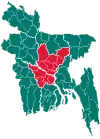
 Boalmari Location in Bangladesh | |
| Coordinates: 23°23.5′N 89°41′E | |
| Country | |
| Division | Dhaka Division |
| District | Faridpur District |
| Area | |
| • Total | 272.34 km2 (105.15 sq mi) |
| Population (1991) | |
| • Total | 190,159 |
| • Density | 700/km2 (1,800/sq mi) |
| Time zone | UTC+6 (BST) |
| Website | boalmari |
Demographics
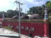
The Satoir Mosque dates back to the 16th century.
As of the 1991 Bangladesh census, Boalmari has a population of 190159. Males constitute 50.63% of the population, and females 49.37%. This Upazila's eighteen up population is 94073. Boalmari has an average literacy rate of 27% (7+ years), and the national average of 32.4% literate.[2]
Administration
Boalmari Upazila is divided into Boalmari Municipality and 11 union parishads: Boalmari, Chandpur, Chatul, Dadpur, Ghoshpur, Gunbaha, Moyna, Parameshwardi, Rupapat, Satair, and Shekhar. The union parishads are subdivided into 173 mauzas and 251 villages.[3]
Boalmari Municipality is subdivided into 9 wards and 18 mahallas.[3]
References
- Achintra Roy Chowdhury (2012). "Boalmari Upazila". In Islam, Sirajul; Miah, Sajahan; Khanam, Mahfuza; Ahmed, Sabbir (eds.). Banglapedia: the National Encyclopedia of Bangladesh (Online ed.). Dhaka, Bangladesh: Banglapedia Trust, Asiatic Society of Bangladesh. ISBN 984-32-0576-6. OCLC 52727562. Retrieved 23 January 2021.
- "Population Census Wing, BBS". Archived from the original on 2005-03-27. Retrieved November 10, 2006.
- "District Statistics 2011: Faridpur" (PDF). Bangladesh Bureau of Statistics. Archived from the original (PDF) on 13 November 2014. Retrieved 14 July 2014.
| Upazila/Thana: | ||
|---|---|---|
This article is issued from Wikipedia. The text is licensed under Creative Commons - Attribution - Sharealike. Additional terms may apply for the media files.
