Charbhadrasan Upazila
Charbhadrasan or Char Bhadrasan (Bengali: চরভদ্রাসন) is an upazila of Faridpur District in the Division of Dhaka, Bangladesh.[1]
Charbhadrasan
চরভদ্রাসন | |
|---|---|
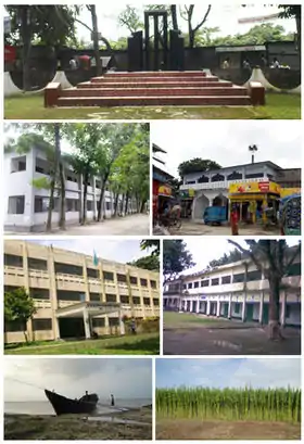
 Skyline of Charbhadrasan, Faridpur, Bangladesh (clockwise from top):Central Shaheed Minar, Charbhadrasan Central Masque, Charbhadrasan Pilot High School, Jute Field, Gopalpur Ghat of Padma, Charbhadrasan Govt. College, Upazila Nirbahi Officer’s Office. | |
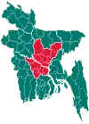
 Charbhadrasan Location in Bangladesh | |
| Coordinates: 23°33.5′N 90°5′E | |
| Country | |
| Division | Dhaka Division |
| District | Faridpur District |
| Establishment | 1914 CE |
| Area | |
| • Total | 141.59 km2 (54.67 sq mi) |
| Elevation | 8 m (29 ft) |
| Population (1991) | |
| • Total | 69,876 |
| • Density | 494/km2 (1,280/sq mi) |
| Time zone | UTC+6 (BST) |
| Postal code | 7810 |
| National calling code | +880 |
| Calling code | 06315 |
| Website | charbhadrasan |
Geography
Charbhadrasan is located at 23.5583°N 90.0833°E. It has 12415 households and total area 141.59 km2. The Geographical position: Charbhadrasan size of a small area. Padma was happy to note that it depends on the size and range. North - South travel through the Doha lauhajam Harirampur in the east - Sadarpur the south, in the south - west of Nagarakanda and west - north - Faridpur Sadar Upazila.
Demographics
As of the 1991 Bangladesh census, Charbhadrasan has a population of 69876. Males constitute 51.36% of the population, and females 48.64%. This Upazila's eighteen up population is 34758. Charbhadrasan has an average literacy rate of 20.5% (7+ years), and the national average of 32.4% literate.[2]
Administration
Charbhadrasan thana was established in 1914 at Charsalehpur. It was turned into an upazila in 1983.
Charbhadrasan Upazila is divided into four union parishads: Char Bhadrasan, Char Harirampur, Char Jahukanda, and Gazirtek. The union parishads are subdivided into 24 mauzas and 80 villages.[3]
See also
- Upazilas of Bangladesh
- Districts of Bangladesh
- Divisions of Bangladesh
- Char Bhadrasan massacre, 1971 massacre of Hindu residents by the Pakistan army
References
- Masud Reza (2012). "Char Bhadrasan Upazila". In Sirajul Islam and Ahmed A. Jamal (ed.). Banglapedia: National Encyclopedia of Bangladesh (Second ed.). Asiatic Society of Bangladesh.
- "Population Census Wing, BBS". Archived from the original on 27 March 2005. Retrieved 10 November 2006.
- "District Statistics 2011: Faridpur" (PDF). Bangladesh Bureau of Statistics. Archived from the original (PDF) on 13 November 2014. Retrieved 14 July 2014.
