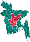
Kapasia Upazila
Kapasia (Bengali: কাপাসিয়া) is an upazila (sub-district) of Gazipur District in central Bangladesh, part of the Dhaka Division.[1] It is located at 24.1000°N 90.5708°E, and is best known as the home upazila of Tajuddin Ahmad, the first Prime Minister of Bangladesh. The modern-day upazila was a part of the historic Bhawal Estate and falls within its boundary.
Kapasia
কাপাসিয়া | |
|---|---|
 Kapasia Location in Bangladesh | |
| Coordinates: 24°6′N 90°34.2′E | |
| Country | |
| Division | Dhaka Division |
| District | Gazipur District |
| Capital | Kapasia Union |
| Thana | 1924 |
| Upazila | 15 December 1982 |
| Named for | Cotton |
| Government | |
| • MP (Gazipur-4) | Simeen Hussain Rimi |
| Area | |
| • Total | 356.98 km2 (137.83 sq mi) |
| Population (1991) | |
| • Total | 303,710 |
| • Density | 851/km2 (2,200/sq mi) |
| Time zone | UTC+6 (BST) |
| 1730 | 1739 |
| Website | kapasia |
Etymology
The name is said to have come from karpas (কার্পাস), a Bengali word for cotton. It is said that the area has been known for its cotton industry since the 1st century.[2]
History
In the 15th century, Isa Khan and the Baro-Bhuiyans built up resistance in the modern-day Kapasia against Man Singh I, the Mughal governor of Bengal Subah, and a number of face-offs took place here. The village of Teetbady became famed for its muslin manufacturing.[3] An earthquake in the 16th century led to char islands forming in eastern Kapasia upon the Brahmaputra River.
In 1924, the Kapasia thana (police outpost), which had 26 Unions, was divided into Kapasia, Kaliganj and Sreepur. 11 Unions remained with Kapasia. During the Bangladesh Liberation War of 1971, the Pakistan Army sacked the entire marketplace in May and conducted mass killings across the village of Taragaon. Later, the Bengali freedom fighters attacked the Kapasia Police Station, capturing arms and ammunitions. An brawl took place in the village of Najai, Raniganj and at a place adjacent to the Raonat Bridge. On 13 August, The Circle Officer's office was attacked with grenades by the freedom fighters. Further encounters took place in October, in the villages of Taragaon and Kheyaghat. Sajjad of Taragaon was martyred and a monument for the freedom fighters was established in front of the Muktijoddha Sangsad premises.[1]
The Tornadoes of 2003 heavily damaged settlements in the village of Kamargaon. Landslides on 22 February 2004 also damaged the village of Dasshu Narayanpur. On 15 December 1982, Kapasia was upgraded to an upazila (sub-district).[4]
Demographics
According to the 1991 Bangladesh census, Kapasia had a population of 303,710, of whom 154,204 were aged 18 or over. In 1881, the population was 119,515.[5] Males constituted 50.83% of the population, and females 49.17%. Kapasia has an average literacy rate of 37% (7+ years), against the national average of 32.4%.[6] Majority of the inhabitants are Bengali Muslims, though there are also communities of Rajbongshis, Santals and Mandis.
Economy
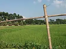
Kapasia is a part of Gazipur District's Agricultural Area. Fishery is also popular along with farming. There has been an earlier project in Kapasia Upazila where the WorldFish Center with funding from the International Fund for Agricultural Development (IFAD) and the Danish International Development Agency (Danida), had researched on farming systems and had introduced adaptive integrated aquaculture practices.[7]
Points of interest
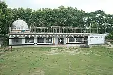
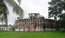
Historically home to Shishupala,[8] the ruins of the ancient capital and reservoir can still be found today. Kapasia is filled with numerous medieval forts such as the Ekdala Fort, Dardaria Fort, Tok Fort and the Karnapur Fort. Out of the upazila's 594 mosques, some notable one include the Sultanpur-Dargapara Shahi Jame Masjid in Tok.[9] The Raniganj Neelkuthi (indigo-house), dating back to the 1800s, and the Dak Bungalow of Lakhpur are both examples of colonial-era architecture. The Joradighi (a joint pair of reservoirs), the Dhadarchar (Shitalakshya-Brahmaputra confluence), Baniar Beel, Nail Beel, Machha Beel, Buri Beel, Suti canal and the Kamra EcoPark are popular natural tourist sites. Other tourist sites include the Faqir Majnu Shah Bridge, Angona Amusement Centre and the home of Tajuddin Ahmad, first Prime Minister of Bangladesh, in Durdaria.[1]
Administration

Kapasia Upazila is divided into 11 union parishads: Barishab, Chandpur, Durgapur, Ghagotia, Kapasia, Karihata, Rayed, Sonmania, Sinhasree, Targoan, and Tokh. The union parishads are subdivided into 81 mauzas and 172 villages.[10]
Transport
Roads, waterways and railways are also available in the Kapasia upazila with the Aah Towfiq Public Service. On the way from Dhaka, Phulbaria and Mohakhali bus stand, Kapasia-bound bus CNG is available, which are located at Chandasura Chaurasta and Rajendrapur Chaurasta to Kapasia upazila.
It is possible to travel to Kapasia upazila on the river Shitalakshya via Dhaka. From Kamalapur railway station to the Rajendrapur station on the railway, the road can be reached to Kapasia upazila.
Notable people
- Tajuddin Ahmad, first Prime Minister of Bangladesh
- Afsaruddin Ahmad, lawyer
- Hannan Shah, army officer
- Mohammad Sanaullah, physician
- Mohammad Shahidullah, politician
- Mohammad Obaid Ullah, politician
- Simeen Hussain Rimi, politician
- Tanjim Ahmad Sohel Taj, politician
Further reading
- Shamsul Huda Liton. দুই হাজার বছরের প্রাচীনতম জনপদ কাপাসিয়ার ইতিহাস-ঐতিহ্য [The history and tradition of 2000 year old ancient civilisation Kapasia] (in Bengali).
References
- Muhammad Nazrul Islam (2012). "Kapasia Upazila". In Islam, Sirajul; Miah, Sajahan; Khanam, Mahfuza; Ahmed, Sabbir (eds.). Banglapedia: the National Encyclopedia of Bangladesh (Online ed.). Dhaka, Bangladesh: Banglapedia Trust, Asiatic Society of Bangladesh. ISBN 984-32-0576-6. OCLC 52727562. Retrieved 22 January 2021.
- Clay, Arthur Lloyd (1896). Leaves from a Diary in Lower Bengal. Macmillan. p. 144.
- Abdul Karim (2012). "Muslin". In Islam, Sirajul; Miah, Sajahan; Khanam, Mahfuza; Ahmed, Sabbir (eds.). Banglapedia: the National Encyclopedia of Bangladesh (Online ed.). Dhaka, Bangladesh: Banglapedia Trust, Asiatic Society of Bangladesh. ISBN 984-32-0576-6. OCLC 52727562. Retrieved 22 January 2021.
- কাপাসিয়া উপজেলার পটভূমি [Background of Kapasia Upazila]. Kapasia Upazila (in Bengali).
- Thornton, Edward (1886). A Gazetteer of the Territories Under the Government of the Viceroy of India. W. H. Allen & Company. p. 421.
- "Population Census Wing, BBS". Archived from the original on 2005-03-27. Retrieved November 10, 2006.
- "Aqua and Agriculture".
- Wise, James (1874). "On the Barah Bhuyas of Eastern Bengal". Journal of the Asiatic Society of Bengal: 200.
- MA Bari (2012). "Sultanpur Mosque, Gazipur". In Islam, Sirajul; Miah, Sajahan; Khanam, Mahfuza; Ahmed, Sabbir (eds.). Banglapedia: the National Encyclopedia of Bangladesh (Online ed.). Dhaka, Bangladesh: Banglapedia Trust, Asiatic Society of Bangladesh. ISBN 984-32-0576-6. OCLC 52727562. Retrieved 22 January 2021.
- "District Statistics 2011: Gazipur" (PDF). Bangladesh Bureau of Statistics. Archived from the original (PDF) on 13 November 2014. Retrieved 14 July 2014.