Brugnens
Brugnens is a commune in the Gers department in southwestern France.
Brugnens | |
|---|---|
Location of Brugnens 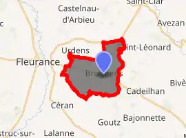
| |
 Brugnens  Brugnens | |
| Coordinates: 43°50′28″N 0°43′48″E | |
| Country | France |
| Region | Occitanie |
| Department | Gers |
| Arrondissement | Condom |
| Canton | Fleurance-Lomagne |
| Intercommunality | Lomagne Gersoise |
| Government | |
| • Mayor (2008–2014) | Pierre Combedouzon |
| Area 1 | 13.45 km2 (5.19 sq mi) |
| Population (2017-01-01)[1] | 256 |
| • Density | 19/km2 (49/sq mi) |
| Time zone | UTC+01:00 (CET) |
| • Summer (DST) | UTC+02:00 (CEST) |
| INSEE/Postal code | 32066 /32500 |
| Elevation | 97–200 m (318–656 ft) (avg. 192 m or 630 ft) |
| 1 French Land Register data, which excludes lakes, ponds, glaciers > 1 km2 (0.386 sq mi or 247 acres) and river estuaries. | |
Geography
The river Auroue forms all of the commune's eastern border.
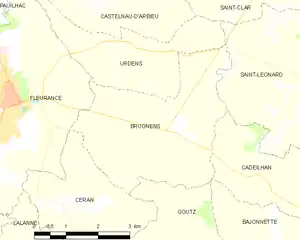
Brugnens and its surrounding communes
Population
| Year | Pop. | ±% |
|---|---|---|
| 1962 | 273 | — |
| 1968 | 251 | −8.1% |
| 1975 | 221 | −12.0% |
| 1982 | 231 | +4.5% |
| 1990 | 244 | +5.6% |
| 1999 | 250 | +2.5% |
| 2008 | 257 | +2.8% |
See also
References
- "Populations légales 2017". INSEE. Retrieved 6 January 2020.
| Wikimedia Commons has media related to Brugnens. |
| Authority control |
|---|
This article is issued from Wikipedia. The text is licensed under Creative Commons - Attribution - Sharealike. Additional terms may apply for the media files.
