Tournecoupe
Tournecoupe is a commune in the Gers department in southwestern France.
Tournecoupe | |
|---|---|
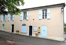 Town hall | |
.svg.png.webp) Coat of arms | |
Location of Tournecoupe 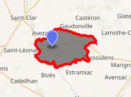
| |
 Tournecoupe  Tournecoupe | |
| Coordinates: 43°51′50″N 0°48′42″E | |
| Country | France |
| Region | Occitanie |
| Department | Gers |
| Arrondissement | Condom |
| Canton | Fleurance-Lomagne |
| Government | |
| • Mayor (2008–2014) | Gérard Bassau |
| Area 1 | 18.95 km2 (7.32 sq mi) |
| Population (2017-01-01)[1] | 263 |
| • Density | 14/km2 (36/sq mi) |
| Time zone | UTC+01:00 (CET) |
| • Summer (DST) | UTC+02:00 (CEST) |
| INSEE/Postal code | 32452 /32380 |
| Elevation | 97–221 m (318–725 ft) (avg. 164 m or 538 ft) |
| 1 French Land Register data, which excludes lakes, ponds, glaciers > 1 km2 (0.386 sq mi or 247 acres) and river estuaries. | |
Geography
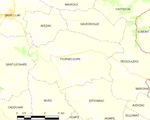
Tournecoupe and its surrounding communes
Population
| Year | Pop. | ±% |
|---|---|---|
| 1962 | 469 | — |
| 1968 | 439 | −6.4% |
| 1975 | 416 | −5.2% |
| 1982 | 349 | −16.1% |
| 1990 | 276 | −20.9% |
| 1999 | 267 | −3.3% |
| 2008 | 283 | +6.0% |
See also
References
- "Populations légales 2017". INSEE. Retrieved 6 January 2020.
| Wikimedia Commons has media related to Tournecoupe. |
| Authority control |
|---|
This article is issued from Wikipedia. The text is licensed under Creative Commons - Attribution - Sharealike. Additional terms may apply for the media files.
