Plieux
Plieux is a commune in the Gers department in southwestern France.
Plieux | |
|---|---|
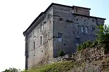
_Gers.jpg.webp) Château de Plieux | |
Location of Plieux 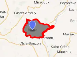
| |
 Plieux  Plieux | |
| Coordinates: 43°57′05″N 0°44′05″E | |
| Country | France |
| Region | Occitanie |
| Department | Gers |
| Arrondissement | Condom |
| Canton | Lectoure-Lomagne |
| Government | |
| • Mayor (2008–2014) | Roger Sigala |
| Area 1 | 12.27 km2 (4.74 sq mi) |
| Population (2017-01-01)[1] | 134 |
| • Density | 11/km2 (28/sq mi) |
| Time zone | UTC+01:00 (CET) |
| • Summer (DST) | UTC+02:00 (CEST) |
| INSEE/Postal code | 32320 /32340 |
| Elevation | 82–187 m (269–614 ft) (avg. 187 m or 614 ft) |
| 1 French Land Register data, which excludes lakes, ponds, glaciers > 1 km2 (0.386 sq mi or 247 acres) and river estuaries. | |
Geography
Locality
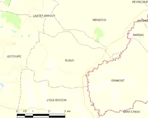
Plieux and its surrounding communes
Population
| Year | Pop. | ±% |
|---|---|---|
| 1962 | 245 | — |
| 1968 | 232 | −5.3% |
| 1975 | 214 | −7.8% |
| 1982 | 195 | −8.9% |
| 1990 | 186 | −4.6% |
| 1999 | 174 | −6.5% |
| 2008 | 161 | −7.5% |
See also
References
- "Populations légales 2017". INSEE. Retrieved 6 January 2020.
| Wikimedia Commons has media related to Plieux. |
| Authority control |
|
|---|
This article is issued from Wikipedia. The text is licensed under Creative Commons - Attribution - Sharealike. Additional terms may apply for the media files.
