Lartigue, Gers
Lartigue is a commune in the Gers department in southwestern France.
Lartigue | |
|---|---|
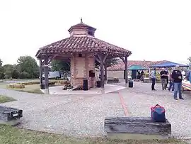 The communal bread oven in Lartigue | |
.svg.png.webp) Coat of arms | |
Location of Lartigue 
| |
 Lartigue  Lartigue | |
| Coordinates: 43°31′53″N 0°43′17″E | |
| Country | France |
| Region | Occitanie |
| Department | Gers |
| Arrondissement | Auch |
| Canton | Astarac-Gimone |
| Government | |
| • Mayor (2008–2014) | Arnauld Wadel |
| Area 1 | 14.89 km2 (5.75 sq mi) |
| Population (2017-01-01)[1] | 183 |
| • Density | 12/km2 (32/sq mi) |
| Time zone | UTC+01:00 (CET) |
| • Summer (DST) | UTC+02:00 (CEST) |
| INSEE/Postal code | 32198 /32450 |
| Elevation | 170–296 m (558–971 ft) (avg. 235 m or 771 ft) |
| 1 French Land Register data, which excludes lakes, ponds, glaciers > 1 km2 (0.386 sq mi or 247 acres) and river estuaries. | |
Geography
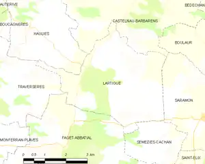
Lartigue and its surrounding communes
Population
| Year | Pop. | ±% |
|---|---|---|
| 1962 | 135 | — |
| 1968 | 155 | +14.8% |
| 1975 | 130 | −16.1% |
| 1982 | 138 | +6.2% |
| 1990 | 137 | −0.7% |
| 1999 | 164 | +19.7% |
| 2008 | 145 | −11.6% |
See also
References
- "Populations légales 2017". INSEE. Retrieved 6 January 2020.
| Wikimedia Commons has media related to Lartigue (Gers). |
| Authority control |
|---|
This article is issued from Wikipedia. The text is licensed under Creative Commons - Attribution - Sharealike. Additional terms may apply for the media files.