Troncens
Troncens is a commune in the Gers department of Gascony in the southwestern France.
Troncens | |
|---|---|
.JPG.webp) A general view of Troncens | |
Location of Troncens 
| |
 Troncens  Troncens | |
| Coordinates: 43°27′41″N 0°12′57″E | |
| Country | France |
| Region | Occitanie |
| Department | Gers |
| Arrondissement | Mirande |
| Canton | Pardiac-Rivière-Basse |
| Intercommunality | Bastides et vallons du Gers |
| Government | |
| • Mayor (2008–2014) | Francis Daguzan |
| Area 1 | 12.97 km2 (5.01 sq mi) |
| Population (2017-01-01)[1] | 184 |
| • Density | 14/km2 (37/sq mi) |
| Time zone | UTC+01:00 (CET) |
| • Summer (DST) | UTC+02:00 (CEST) |
| INSEE/Postal code | 32455 /32230 |
| Elevation | 182–342 m (597–1,122 ft) (avg. 150 m or 490 ft) |
| 1 French Land Register data, which excludes lakes, ponds, glaciers > 1 km2 (0.386 sq mi or 247 acres) and river estuaries. | |
Geography
Localisation
Troncens is situated in the south of the department near the department of Hautes-Pyrenees.
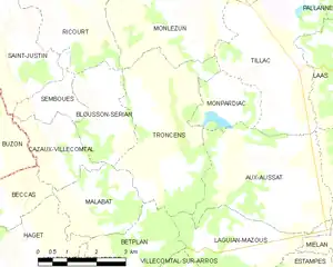
Troncens and its surrounding communes
Hydrography
The Cabournieu, right tributary of the Bouès, has its source in the town. Another tributary (left bank) of the Bouès, the Laus, runs through the town. The farms are dispersed throughout the area.
Population
| Year | Pop. | ±% |
|---|---|---|
| 522 | 1,818 | — |
| 416 | 1,848 | +1.7% |
| 652 | 1,896 | +2.6% |
| 429 | 1,912 | +0.8% |
| 402 | 1,947 | +1.8% |
| 278 | 1,962 | +0.8% |
| 219 | 1,968 | +0.3% |
| 198 | 1,975 | +0.4% |
| 197 | 1,982 | +0.4% |
| 206 | 1,990 | +0.4% |
| 206 | 1,999 | +0.5% |
| 199 | 2,008 | +0.5% |
| 184 | — |
Businesses and artisans
- Agriculture: sunflower, corn
- 1 gîte: CAP de BOUEOU (bouéou = beef in Gascon dialect) - Vacation rental in an 18th-century farmhouse in Troncens, Gers.
See also
References
- "Populations légales 2017". INSEE. Retrieved 6 January 2020.
| Wikimedia Commons has media related to Troncens. |
| Authority control |
|---|
This article is issued from Wikipedia. The text is licensed under Creative Commons - Attribution - Sharealike. Additional terms may apply for the media files.