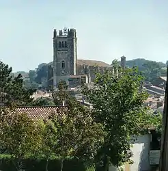
Condom, Gers
Condom (Occitan: Condòm; French pronunciation: [kɔ̃dɔ̃]), also referred to as Condom-en-Armagnac, is a commune in southwestern France in the department of Gers, of which it is a subprefecture.
Condom | |
|---|---|
Subprefecture and commune | |
 | |
.svg.png.webp) Coat of arms | |
Location of Condom 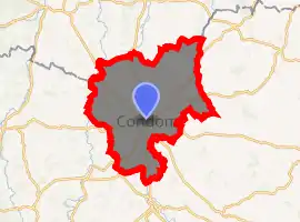
| |
 Condom  Condom | |
| Coordinates: 43°58′N 0°22′E | |
| Country | France |
| Region | Occitanie |
| Department | Gers |
| Arrondissement | Condom |
| Canton | Baïse-Armagnac |
| Intercommunality | La Ténarèze |
| Government | |
| • Mayor (2014–2020) | Gérard Dubrac |
| Area 1 | 97.37 km2 (37.59 sq mi) |
| Population (2017-01-01)[1] | 6,530 |
| • Density | 67/km2 (170/sq mi) |
| Time zone | UTC+01:00 (CET) |
| • Summer (DST) | UTC+02:00 (CEST) |
| INSEE/Postal code | 32107 /32100 |
| Elevation | 62–190 m (203–623 ft) (avg. 82 m or 269 ft) |
| 1 French Land Register data, which excludes lakes, ponds, glaciers > 1 km2 (0.386 sq mi or 247 acres) and river estuaries. | |
Geography
Localisation
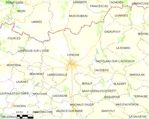
The town of Condom is located in the northern part of the department of Gers, halfway between Mont-de-Marsan (to the west) and Montauban (to the east), and north of Auch.
Roads and transports
- Way of St. James
Condom is a town on the Via Podiensis, one of the three major French arms of the pilgrimage route, the Way of St. James.
This particular route begins in Le Puy and ends in Santiago de Compostela in northwest Spain. Pilgrims arrive at Condom after Miradoux and continue on to Larressingle.
Toponymy
There is no relationship between the English word condom and this town. The toponym Condom comes from the Gaulish words condate and magos combined into Condatomagos, which means "market or field, of the confluence".
Condatómagos evolved into Condatóm and then into Conddóm. Condom was first recorded in Latin in the 10th century as Condomus or Condomium.[2] It is where the river Gèle flows into the river Baïse.
Although the French word for a condom is préservatif, in 1995 the town's mayor, taking advantage of the incidental relationship between the town's name and the English word, opened a museum of contraceptives, which closed in 2005.[3]
Politics and administration
Mayors
| Mayor | Term start | Term end |
|---|---|---|
| Jean Dubos | 1983 | 1983 |
| Jacques Moisan | 1989 | 1995 |
| Gérard Dubrac | 1995 | 2008 |
| Bernard Gallardo | 2008 | 2014 |
| Gérard Dubrac | 2014 |
Population
|
|
Sites of interest
Condom is the site of two castles, the Château de Mothes and the Château de Pouypardin, both started in the 13th century. In total, 19 sites in Condom are listed as monuments historiques by the French Ministry of Culture, including the cathedral, churches and houses.
Condom is known for the production of Armagnac, an international music festival of "bandas", an international chess tournament and an international chess marathon. It is also known for its tourism with farm campings and boating on waterways. It is also home to a museum about Armagnac.[4][5]
A statue of The Three Musketeers and d'Artagnan stands beside the cathedral and was created in 2010 by Zurab Tsereteli.[6]
Notable people
- Blaise de Montluc, marshal of France, buried in Condom.
- Scipion Dupleix (1569-1661).
- Jacques-Bénigne Bossuet (1627-1704).
- Jean-Charles Persil (1785-1870).
- Narcisse-Achille de Salvandy (1795-1856).
- Sarah Maldoror (1929-2020).
- Stéphane Abrial (1954-), French general born in Condom.[7]
- Siouxsie Sioux (1957-), English singer and songwriter, moved to Condom in 1992 and left in 2015.[8]
- Grégory Alldritt (1997-), French Rugby Union player
References
- "Populations légales 2017". INSEE. Retrieved 6 January 2020.
- Ernest Nègre, "Toponymie générale de la France, Volume 1", p.192
- Meslin, Franck (4 August 2012). "La capote colle toujours à la peau de Condom Tous les projets ont capoté". Sud-Ouest (in French). Retrieved 28 May 2013.
- Musée de l'Armagnac Pays en France (retrieved November 6, 2007)
- The Town of Condom (retrieved November 6, 2007)
- http://www.shutterstock.com/pic-73234222/stock-photo-condom-france-september-statue-of-d-artagnan-and-the-three-musketeers-the-sculptor-is-zurab.html
- "General Stéphane Abrial: Chief of Staff of the French Air Force" (PDF). NATO. 2009-08-04. Retrieved 16 September 2016.
- Morrissey, "Autobiography", Penguin Classics, 2014.
External links
| Wikimedia Commons has media related to Condom (Gers). |
- Official website (in French)
- Base Mérimée: Search for heritage in the commune, Ministère français de la Culture. (in French)
- Pictures of Condom (in French)
- Le bonheur est dans le pré (Internet Movie Database)
| Authority control |
|---|