Chilkoot Trail and Dyea Site
The Chilkoot Trail and Dyea Site is a National Historic Landmark district comprising the Chilkoot Trail and the former town of Dyea, Alaska. They are contained in the Klondike Gold Rush National Historical Park which preserves the historic buildings and locations connected to the Klondike Gold Rush period of Alaskan history. For a brief period between 1897 and 1899, this trail and town were full of prospectors. By 1905, most of the buildings had been demolished or removed.[2] Both the trail and the town site are part of the Klondike Gold Rush National Historical Park.[3][4]
Chilkoot Trail and Dyea Site | |
Alaska Heritage Resources Survey
| |
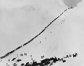 Miners climbing Chilkoot | |
 | |
| Nearest city | Skagway, Alaska |
|---|---|
| Coordinates | 59°35′14″N 135°19′56″W |
| Area | 11,882 acres (4,808 ha) |
| Built | 1897 |
| Part of | Klondike Gold Rush National Historical Park (ID76002189) |
| NRHP reference No. | 75002120[1] |
| AHRS No. | SKG-006; SKG-067 |
| Significant dates | |
| Added to NRHP | April 14, 1975 |
| Designated NHLD | June 16, 1978[2] |
| Designated CP | June 30, 1976 |
| Designated AHRS | June 30, 1974 December 14, 1974 |
Dyea
Dyea is a ghost town located at the convergence of the Taiya River and Taiya Inlet on the south side of the Chilkoot Pass within the limits of the Municipality of Skagway Borough, Alaska. During the Klondike Gold Rush prospectors disembarked at its port and used the Chilkoot Trail, a Tlingit trade route over the Coast Mountains, to begin their journey to the gold fields around Dawson City, Yukon, about 800 km (500 mi) away. Confidence man and crime boss Soapy Smith, famous for his underworld control of the neighboring town of Skagway in 1897-98 is believed to have had control of Dyea as well.[5]
The port at Dyea had shallow water, while neighboring Skagway had deep water. Dyea was abandoned when the White Pass and Yukon Route railroad chose the White Pass Trail, which begins in Skagway, over the Chilkoot Trail
Chilkoot Trail
The Chilkoot Trail is a 33-mile (53 km) trail through the Coast Mountains that leads from Dyea to Bennett, British Columbia, in Canada. Tlingit First Nations used the trail as a vital trade route to trade for resources available in the interior. As pressures from American settlers and the Hudson's Bay Company weakened the traditional Tlingit trading system, the Chilkoot Trail slowly became utilized by explorers and prospectors.
The Klondike Gold Rush transformed the Chilkoot Trail into a mainstream transportation route to Canada's interior. The gold rush was primarily focused in the region around Dawson City in Yukon and the Yukon River. Of the several overland routes, the Chilkoot Trail was the most direct, least expensive, and, soon enough, most popular. It was eclipsed by the construction of the railway from Skagway, and was soon abandoned.
See also
References
- "National Register Information System". National Register of Historic Places. National Park Service. March 13, 2009.
- "Chilkoot Trail and Dyea Site". National Historic Landmark summary listing. National Park Service. Archived from the original on November 29, 2014. Retrieved June 5, 2017.
- "Nomination Form for Chilkoot Trail and Dyea Site". Retrieved June 5, 2017.
- "Nomination Form for Klondike Gold Rush National Historical Park". Retrieved June 5, 2017.
- Smith, Jeff (2009). Alias Soapy Smith: The Life and Death of a Scoundrel, Klondike Research. pp. 450-51. ISBN 0-9819743-0-9
Boroughs | .svg.png.webp) | ||
Census areas | |||
There are no sites listed on the National Register of Historic Places in Kusilvak Census Area. | |||
| Topics | |
|---|---|
| Lists by state |
|
| Lists by insular areas | |
| Lists by associated state | |
| Other areas | |
| Related | |
| |