National Register of Historic Places listings in Hoonah–Angoon Census Area, Alaska

This is a list of the National Register of Historic Places listings in Hoonah–Angoon Census Area, Alaska.

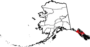
Location of the Hoonah-Angoon Census Area in Alaska

This is intended to be a complete list of the properties and districts on the National Register of Historic Places in Hoonah-Angoon Census Area, Alaska, United States. The locations of National Register properties and districts for which the latitude and longitude coordinates are included below, may be seen in a Google map.[1]

There are 20 properties and districts listed on the National Register in the census area.

This National Park Service list is complete through NPS recent listings posted February 5, 2021.[2]
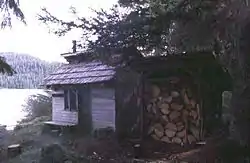
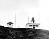
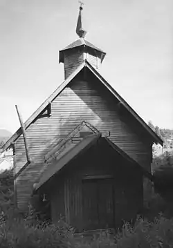
Current listings

[3] Name on the Register[4] Image Date listed[5] Location City or town Description
1 Alexander Lake Shelter Cabin
Alexander Lake Shelter Cabin
November 2, 1995
(#95001296)
Eastern end of Lake Alexander, Admiralty Island National Monument
57°39′45″N 134°08′39″W
Angoon
2 Beaver Lake Dam November 2, 1995
(#95001295)
Between Beaver Lake and Lake Alexander, Admiralty Island National Monument
57°40′15″N 134°11′31″W
Angoon
3 Big Shaheen Cabin
Big Shaheen Cabin
November 2, 1995
(#95001292)
On Hasselborg Lake, Admiralty Island National Monument
57°42′04″N 134°16′42″W
Angoon
4 Cape Spencer Lighthouse
Cape Spencer Lighthouse
December 4, 1975
(#75002160)
About 44 miles (71 km) west of Hoonah, at entrance of Cross Sound
58°11′56″N 136°38′25″W
Elfin Cove
5 Davidson Lake Shelter Cabin November 2, 1995
(#95001303)
Western end of Davidson Lake, Admiralty Island National Monument
57°36′15″N 134°22′48″W
Angoon
6 Distin Lake Shelter Cabin
Distin Lake Shelter Cabin
November 2, 1995
(#95001294)
Northwestern shore of Distin Lake, Admiralty Island National Monument
57°37′46″N 134°24′07″W
Angoon
7 Hasselborg Cabin November 2, 1995
(#95001291)
Along Hasselborg Creek, on Hasselborg Lake, Admiralty Island National Monument
57°39′47″N 134°15′15″W
Angoon
8 Hasselborg Lake East Shelter Cabin November 2, 1995
(#95001308)
Eastern shore of Hasselborg Lake, Admiralty Island National Monument
57°40′06″N 134°12′49″W
Angoon
9 Hasselborg Lake North Shelter Cabin November 2, 1995
(#95001307)
Northern shore of Hasselborg Lake, Admiralty Island National Monument
57°46′03″N 134°19′20″W
Angoon
10 Hasselborg Lake South Shelter Cabin November 2, 1995
(#95001300)
Western shore of Hasselborg Lake, Admiralty Island National Monument
57°39′59″N 134°15′23″W
Angoon
11 Lake Guerin East Shelter Cabin November 2, 1995
(#95001306)
Eastern end of Lake Guerin, Admiralty Island National Monument
57°39′37″N 134°17′12″W
Angoon
12 Lake Guerin West Shelter Cabin November 2, 1995
(#95001301)
Western end of Lake Guerin, Admiralty Island National Monument
57°38′57″N 134°20′36″W
Angoon
13 Mitchell Bay Shelter Cabin November 2, 1995
(#95001302)
Northwestern shore of Mitchell Bay, Admiralty Island National Monument
57°33′52″N 134°23′54″W
Angoon
14 Mole Harbor Shelter Cabin November 2, 1995
(#95001297)
Head of Mole Harbor, Admiralty Island National Monument
57°39′34″N 134°06′00″W
Angoon
15 Point Retreat Light Station
Point Retreat Light Station
June 19, 2003
(#03000529)
Mansfield Peninsula, northern end of Admiralty Island
58°24′41″N 134°57′18″W
Juneau
16 St. John the Baptist Church
St. John the Baptist Church
June 6, 1980
(#80004589)
On hillside north of Beaver Trail Street
57°30′13″N 134°35′14″W
Angoon Russian Orthodox Church
17 Thayer Lake East Shelter Cabin November 2, 1995
(#95001309)
Eastern shore of Thayer Lake southern arm, Admiralty Island National Monument
57°38′03″N 134°27′53″W
Angoon
18 Thayer Lake North Shelter Cabin November 2, 1995
(#95001304)
Northern end of Thayer Lake, Admiralty Island National Monument
57°41′22″N 134°24′44″W
Angoon
19 Thayer Lake South Shelter Cabin November 2, 1995
(#95001298)
Southern end of Thayer Lake, Admiralty Island National Monument
57°35′51″N 134°28′12″W
Angoon
20 Windfall Harbor Shelter Cabin November 2, 1995
(#95001299)
Southwestern shore of Windfall Harbor, Admiralty Island National Monument
57°50′07″N 134°18′29″W
Angoon

See also

References

  1. The latitude and longitude information provided in this table was derived originally from the National Register Information System, which has been found to be fairly accurate for about 99% of listings. Some locations in this table may have been corrected to current GPS standards.
  2. "National Register of Historic Places: Weekly List Actions". National Park Service, United States Department of the Interior. Retrieved on February 5, 2021.
  3. Numbers represent an alphabetical ordering by significant words. Various colorings, defined here, differentiate National Historic Landmarks and historic districts from other NRHP buildings, structures, sites or objects.
  4. "National Register Information System". National Register of Historic Places. National Park Service. April 24, 2008.
  5. The eight-digit number below each date is the number assigned to each location in the National Register Information System database, which can be viewed by clicking the number.
This article is issued from Wikipedia. The text is licensed under Creative Commons - Attribution - Sharealike. Additional terms may apply for the media files.