National Register of Historic Places listings in Yukon–Koyukuk Census Area, Alaska
This is a list of the National Register of Historic Places listings in Yukon–Koyukuk Census Area, Alaska.
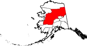
Location of the Yukon-Koyukuk Census Area in Alaska
This is intended to be a complete list of the properties and districts on the National Register of Historic Places in Yukon-Koyukuk Census Area, Alaska, United States. The locations of National Register properties and districts for which the latitude and longitude coordinates are included below, may be seen in a Google map.[1]
There are 16 properties and districts listed on the National Register in the census area. Another 2 properties were once listed but have been removed.
- This National Park Service list is complete through NPS recent listings posted February 5, 2021.[2]
Current listings
| [3] | Name on the Register[4] | Image | Date listed[5] | Location | City or town | Description |
|---|---|---|---|---|---|---|
| 1 | Ed Beiderman Fish Camp | 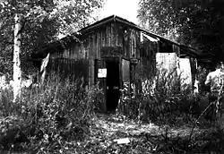 Ed Beiderman Fish Camp |
July 20, 1987 (#87001204) |
Left bank of Yukon River, about 56 miles (90 km) northwest of Eagle 65°22′34″N 142°32′18″W |
Eagle | |
| 2 | Bettles Lodge | May 8, 1997 (#97000401) |
1 Airline Drive, Bettles Field 66°55′05″N 151°31′06″W |
Bettles | ||
| 3 | Central House | July 31, 1978 (#78003431) |
Mile 128 of Steese Highway 65°34′21″N 144°47′56″W |
Central | Building collapsed at an uncertain date and is no more standing.[lower-alpha 1] | |
| 4 | Christ Church Mission | 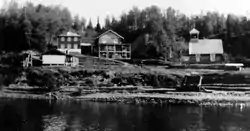 Christ Church Mission |
May 8, 1980 (#80004572) |
Corner of Main Road and River Road 62°39′20″N 160°12′11″W |
Anvik | |
| 5 | Coal Creek Historic Mining District | 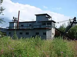 Coal Creek Historic Mining District |
May 4, 1995 (#95000573) |
Along Coal Creek, about 44 miles (71 km) southeast of Circle 65°18′12″N 143°09′22″W |
Circle | |
| 6 | George McGregor Cabin | 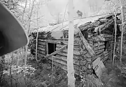 George McGregor Cabin |
July 21, 1987 (#87001199) |
About 2 miles (3.2 km) west of Coal Creek 65°21′11″N 143°11′48″W |
Eagle | |
| 7 | Mission Church | April 11, 1977 (#77001578) |
Main Street 68°07′44″N 145°32′18″W |
Arctic Village | ||
| 8 | Nenana Depot | 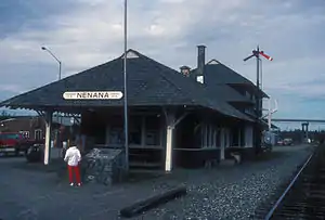 Nenana Depot |
August 10, 1977 (#77000229) |
900 A Street 64°33′52″N 149°05′45″W |
Nenana | Building now hosting the Alaska State Railroad Museum. |
| 9 | Old Mission House | November 7, 1978 (#78000539) |
Along Winter Trail 66°33′57″N 145°16′36″W |
Fort Yukon | Building not standing anymore at its original location. It is unclear whether it has been destroyed or relocated elsewhere in Fort Yukon.[lower-alpha 2] | |
| 10 | Presentation of Our Lord Chapel | 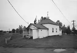 Presentation of Our Lord Chapel |
June 6, 1980 (#80004584) |
Along Telida Trail 63°00′45″N 154°22′35″W |
Nikolai | |
| 11 | Ruby Roadhouse | May 20, 1982 (#82004898) |
On Olson Street, between Ruby-Poorman Drive and Sulatna Road 64°44′20″N 155°29′46″W |
Ruby | ||
| 12 | Frank Slaven Roadhouse | .jpg.webp) Frank Slaven Roadhouse |
July 20, 1987 (#87001202) |
Mouth of Coal Creek, about 42 miles (68 km) southeast of Circle 65°21′02″N 143°07′22″W |
Circle | |
| 13 | Sourdough Inn | December 30, 1997 (#97001585) |
Northwest corner of 1st Avenue and Sled Road 66°33′49″N 145°16′20″W |
Fort Yukon | Building not standing anymore at its original location. It is unclear whether it has been destroyed or relocated elsewhere in Fort Yukon.[lower-alpha 2] | |
| 14 | Tanana Mission | .jpg.webp) Tanana Mission |
August 3, 1977 (#77000230) |
At end of Cemetery Road, about 2.5 miles (4.0 km) east of Tanana 65°10′28″N 151°59′47″W |
Tanana | |
| 15 | Tolovana Roadhouse |  Tolovana Roadhouse |
October 7, 1988 (#88000402) |
At the confluence of Tanana and Tolovana Rivers, about 29 miles (47 km) northwest of Nenana 64°51′13″N 149°49′29″W |
Nenana | |
| 16 | Woodchopper Roadhouse | 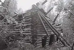 Woodchopper Roadhouse |
July 20, 1987 (#87001201) |
About 1 mile (1.6 km) east of Woodchopper Creek 65°21′22″N 143°18′17″W |
Circle |
Former listings
| [3] | Name on the Register | Image | Date listed | Date removed | Location | City or town | Summary |
|---|---|---|---|---|---|---|---|
| 1 | Miller House | November 5, 1971 (#71001092) | November 6, 1971 | Mile 114.2, Steese Highway, about 12.5 miles (20.1 km) west of Central 65°31′25″N 145°13′30″W |
Central | Destroyed by fire in 1970. | |
| 2 | James Taylor Cabins | July 20, 1987 (#87001203) | August 7, 2000 | North bank of the Yukon opposite Fourth of July Creek, about 34 miles (55 km) northwest of Eagle 65°12′40″N 141°47′10″W |
Eagle | Destroyed by forest fire in 1999. |
See also
| Wikimedia Commons has media related to National Register of Historic Places in Yukon-Koyukuk Census Area, Alaska. |
Notes
- Building remains are still visible, shortly east of Crooked Creek bridge, on Streetview.
- Compare modern satellite imagery with Old Mission House NRHP form containing a sketch map, this 1950 aerial image and this 1972 aerial image where the building is visible.
References
- The latitude and longitude information provided in this table was derived originally from the National Register Information System, which has been found to be fairly accurate for about 99% of listings. Some locations in this table may have been corrected to current GPS standards.
- "National Register of Historic Places: Weekly List Actions". National Park Service, United States Department of the Interior. Retrieved on February 5, 2021.
- Numbers represent an alphabetical ordering by significant words. Various colorings, defined here, differentiate National Historic Landmarks and historic districts from other NRHP buildings, structures, sites or objects.
- "National Register Information System". National Register of Historic Places. National Park Service. April 24, 2008.
- The eight-digit number below each date is the number assigned to each location in the National Register Information System database, which can be viewed by clicking the number.
| Topics | |
|---|---|
| Lists by state |
|
| Lists by insular areas | |
| Lists by associated state | |
| Other areas | |
| Related | |
| |
Boroughs | .svg.png.webp) | ||
Census areas | |||
There are no sites listed on the National Register of Historic Places in Kusilvak Census Area. | |||
Municipalities and communities of Yukon–Koyukuk Census Area, Alaska, United States | ||
|---|---|---|
| Cities | Yukon–Koyukuk Census Area map | |
| CDPs | ||
| Unincorporated communities | ||
| Ghost towns | ||
| ||
This article is issued from Wikipedia. The text is licensed under Creative Commons - Attribution - Sharealike. Additional terms may apply for the media files.