National Register of Historic Places listings in Nome Census Area, Alaska
This is a list of the National Register of Historic Places listings in Nome Census Area, Alaska.
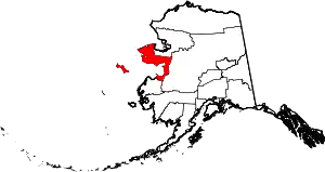
Location of the Nome Census Area in Alaska
This is intended to be a complete list of the properties and districts on the National Register of Historic Places in Nome Census Area, Alaska, United States. The locations of National Register properties and districts for which the latitude and longitude coordinates are included below, may be seen in a Google map.[1]
There are 20 properties and districts listed on the National Register in the census area, including 3 National Historic Landmarks. Another property was once listed but has been removed.
- This National Park Service list is complete through NPS recent listings posted February 5, 2021.[2]
Current listings
| [3] | Name on the Register[4] | Image | Date listed[5] | Location | City or town | Description |
|---|---|---|---|---|---|---|
| 1 | Anvil Creek Gold Discovery Site | 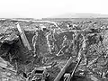 Anvil Creek Gold Discovery Site |
October 15, 1966 (#66000159) |
About 4.25 miles (6.84 km) north of Nome, along Anvil Creek 64°33′13″N 165°25′26″W |
Nome | Also a contributing site to Cape Nome Mining District Discovery Sites. |
| 2 | Jacob Berger House | August 3, 1977 (#77000219) |
308 2nd Avenue 64°29′57″N 165°24′33″W |
Nome | ||
| 3 | Bureau of Indian Affairs Unalakleet School | .jpg.webp) Bureau of Indian Affairs Unalakleet School |
May 22, 2002 (#02000536) |
Along E Street and F Street, west of Main Road 63°52′18″N 160°47′16″W |
Unalakleet | |
| 4 | Cape Nome Mining District Discovery Sites |  Cape Nome Mining District Discovery Sites |
June 2, 1978 (#78000535) |
Nome Beach Site, Anvil Creek Gold Discovery Site, Snow Creek Placer Claim No. 1 and Erik Lindblom Placer Claim 64°32′58″N 165°24′46″W |
Nome | |
| 5 | Cape Nome Roadhouse | 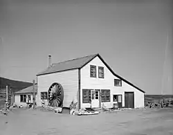 Cape Nome Roadhouse |
December 12, 1976 (#76000361) |
Mile 14 of Nome-Council Highway 64°26′33″N 164°58′38″W |
Nome | |
| 6 | Council City and Solomon River Railroad | 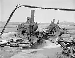 Council City and Solomon River Railroad |
March 2, 2001 (#01000109) |
Mile 31 of Nome-Council Highway 64°32′46″N 164°26′12″W |
Solomon | |
| 7 | Discovery Saloon | .jpg.webp) Discovery Saloon |
April 3, 1980 (#80000759) |
Corner of West Lomen Avenue and West D Street 64°29′58″N 165°24′53″W |
Nome | |
| 8 | Fort St. Michael | 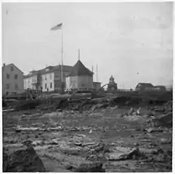 Fort St. Michael |
November 10, 1977 (#77000221) |
Vicinity of St. Michael 63°28′42″N 162°02′23″W |
St. Michael | |
| 9 | Gambell Sites | 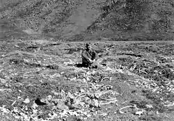 Gambell Sites |
October 15, 1966 (#66000160) |
Address restricted[6] |
St. Lawrence Island | |
| 10 | Iyatayet Site | 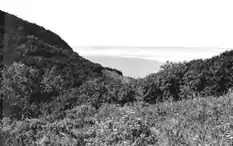 Iyatayet Site |
October 15, 1966 (#66000158) |
Northwestern shore of Cape Denbigh on Norton Bay[7] |
Cape Denbigh Peninsula | |
| 11 | Erik Lindblom Placer Claim | November 21, 1976 (#76000362) |
About 6 miles (9.7 km) northwest of Nome 64°35′10″N 165°26′08″W |
Nome | Also a contributing site to Cape Nome Mining District Discovery Sites. | |
| 12 | Norge Storage Site | October 9, 1974 (#74000441) |
Front Avenue 65°15′43″N 166°21′40″W |
Teller | Warehouse where remains of the Arctic airship Norge were stored after its 1926 overflight of the North Pole. | |
| 13 | Old St. Joseph's Catholic Church | 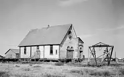 Old St. Joseph's Catholic Church |
March 8, 2000 (#00000149) |
Across Bering Street, in front of West Seppala Drive 64°30′00″N 165°24′28″W |
Nome | |
| 14 | Pilgrim Hot Springs | 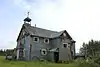 Pilgrim Hot Springs |
April 11, 1977 (#77000223) |
About 8 miles (13 km) south of Mile 65 of Kougarok Road 65°05′34″N 164°55′23″W |
Teller | |
| 15 | St. Michael Redoubt Site | 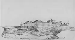 St. Michael Redoubt Site |
November 10, 1977 (#77000222) |
Address restricted[6] |
St. Michael | |
| 16 | Snow Creek Placer Claim No. 1 | September 28, 1976 (#76000363) |
About 6.5 miles (10.5 km) north of Nome 64°35′49″N 165°24′26″W |
Nome | Also a contributing site to Cape Nome Mining District Discovery Sites. | |
| 17 | Solomon Roadhouse | 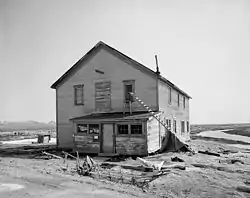 Solomon Roadhouse |
September 17, 1980 (#80000760) |
Mile 32 of Nome-Council Highway 64°33′31″N 164°26′34″W |
Solomon | |
| 18 | Swanberg Dredge | 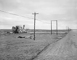 Swanberg Dredge |
March 12, 2001 (#01000232) |
Mile 1 of Nome-Council Highway 64°29′33″N 165°21′58″W |
Nome | |
| 19 | Teller Mission Orphanage | October 21, 2001 (#01001117) |
Corner of Post Officer Road and Tuksuk Street 65°19′57″N 166°29′10″W |
Brevig Mission | Building no more standing since 2015.[lower-alpha 1] | |
| 20 | Wales Sites | 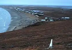 Wales Sites |
October 15, 1966 (#66000161) |
Address restricted[6] |
Wales |
Former listing
| [3] | Name on the Register | Image | Date listed | Date removed | Location | City or town | Summary |
|---|---|---|---|---|---|---|---|
| 1 | Lt. C. V. Donaldson | 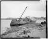 Lt. C. V. Donaldson |
April 11, 1977 (#77000220) | January 3, 1990 | Southern tip of Belmont Point 64°30′05″N 165°25′25″W |
Nome | Wreck no more present on the beach. |
| 2 | Carrie McLain House | December 19, 1978 (#78000534) | June 4, 1990 | Belmont Point |
Nome |
See also
| Wikimedia Commons has media related to National Register of Historic Places in Nome Census Area, Alaska. |
Notes
- Cfr. "Aerial view of Brevig Mission". September 2015. Retrieved June 8, 2017. and modern satellite imagery with maps present in "NRHP nomination for Teller Mission Orphanage". National Park Service. Retrieved 2015-03-24. and "Brevig Mission Local Economic Development Plan" (PDF). January 9, 2014. p. 18. Retrieved June 8, 2017.
References
- The latitude and longitude information provided in this table was derived originally from the National Register Information System, which has been found to be fairly accurate for about 99% of listings. Some locations in this table may have been corrected to current GPS standards.
- "National Register of Historic Places: Weekly List Actions". National Park Service, United States Department of the Interior. Retrieved on February 5, 2021.
- Numbers represent an alphabetical ordering by significant words. Various colorings, defined here, differentiate National Historic Landmarks and historic districts from other NRHP buildings, structures, sites or objects.
- "National Register Information System". National Register of Historic Places. National Park Service. April 24, 2008.
- The eight-digit number below each date is the number assigned to each location in the National Register Information System database, which can be viewed by clicking the number.
- Federal and state laws and practices restrict general public access to information regarding the specific location of this resource. In some cases, this is to protect archeological sites from vandalism, while in other cases it is restricted at the request of the owner. See: Knoerl, John; Miller, Diane; Shrimpton, Rebecca H. (1990), Guidelines for Restricting Information about Historic and Prehistoric Resources, National Register Bulletin, National Park Service, U.S. Department of the Interior, OCLC 20706997.
- This location is derived from its National Historic Landmark data page Archived 2012-09-12 at the Wayback Machine; the NRIS lists it as "Address Restricted"
| Topics | |
|---|---|
| Lists by state |
|
| Lists by insular areas | |
| Lists by associated state | |
| Other areas | |
| Related | |
| |
Boroughs | .svg.png.webp) | ||
Census areas | |||
There are no sites listed on the National Register of Historic Places in Kusilvak Census Area. | |||
Municipalities and communities of Nome Census Area, Alaska, United States | ||
|---|---|---|
| Cities | Nome Census Area map | |
| CDP | ||
| Unincorporated communities | ||
| Ghost towns | ||
| ||
This article is issued from Wikipedia. The text is licensed under Creative Commons - Attribution - Sharealike. Additional terms may apply for the media files.