Coleman, Ontario
Coleman is a township municipality in the Canadian province of Ontario. It is situated in the Timiskaming District of Northeastern Ontario. The township had a population of 595 in the Canada 2016 Census.[1][3][4][5][6]
Coleman | |
|---|---|
| Township of Coleman | |
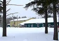 Municipal building | |
| Motto(s): Over 2 billion square feet of opportunity! | |
 Coleman | |
| Coordinates: 47°22′03″N 79°45′34″W[1] | |
| Country | Canada |
| Province | Ontario |
| District | Timiskaming |
| Incorporated | 1906 |
| Government | |
| • Type | Township |
| • Mayor | Dan Cleroux |
| • Federal riding | Nipissing—Timiskaming |
| • Prov. riding | Timiskaming—Cochrane |
| Area | |
| • Land | 178.89 km2 (69.07 sq mi) |
| Population (2016)[2] | |
| • Total | 595 |
| • Density | 3.3/km2 (9/sq mi) |
| Time zone | UTC-5 (EST) |
| • Summer (DST) | UTC-4 (EDT) |
| Postal Code | P0J 1C0 |
| Area codes | 705, 249 |
| Website | www |
It is located along Highway 11 and 11-B.[4][6]
History
The community was first formed around 1906. The township is named after geologist A. P. Coleman, who did extensive work in the region in the late 1800s. Coleman also mapped the Sudbury Basin, leading to important nickel discoveries, and proved conclusively that the area had been repeatedly glaciated. The township celebrated its first 100 years in 2006.
Demographics
| Canada census – Coleman, Ontario community profile | |||
|---|---|---|---|
| 2016 | 2011 | ||
| Population: | 595 (-0.3% from 2011) | 597 (+10.6% from 2006) | |
| Land area: | 178.89 km2 (69.07 sq mi) | 178.82 km2 (69.04 sq mi) | |
| Population density: | 3.3/km2 (8.5/sq mi) | 3.3/km2 (8.5/sq mi) | |
| Median age: | 52.5 (M: 52.3, F: 52.8) | 47.6 (M: , F: ) | |
| Total private dwellings: | 338 | 325 | |
| Median household income: | $67,840 | ||
| References: 2016[7] 2011[8] earlier[9] | |||
| Year | Pop. | ±% |
|---|---|---|
| 1986 | 441 | — |
| 1991 | 470 | +6.6% |
| 1996 | 499 | +6.2% |
| 2001 | 550 | +10.2% |
| 2006 | 580 | +5.5% |
| 2011 | 597 | +2.9% |
| 2016 | 595 | −0.3% |
| [10][11][2]1996 population would be 534 if boundaries of 2001 were used | ||
Mother tongue (2006):[12]
- English as first language: 77.0%
- French as first language: 14.9%
- English and French as first language: 4.6%
- Other as first language: 3.5%
References
- "Coleman". Geographical Names Data Base. Natural Resources Canada. Retrieved 2021-01-16.
- "Census Profile, 2016 Census: Coleman, Township". Statistics Canada. Retrieved July 18, 2019.
- "Toporama (on-line map and search)". Atlas of Canada. Natural Resources Canada. Retrieved 2021-01-16.
- "Ontario Geonames GIS (on-line map and search)". Ontario Ministry of Natural Resources and Forestry. 2014. Retrieved 2021-01-16.
- Restructured municipalities - Ontario map #4 (Map). Restructuring Maps of Ontario. Ontario Ministry of Municipal Affairs and Housing. 2006. Retrieved 2021-01-16.
- Map 13 (PDF) (Map). 1 : 1,600,000. Official road map of Ontario. Ministry of Transportation of Ontario. 2020-01-01. Retrieved 2021-01-12.
- "2016 Community Profiles". 2016 Canadian Census. Statistics Canada. February 21, 2017. Retrieved 2019-07-18.
- "2011 Community Profiles". 2011 Canadian Census. Statistics Canada. July 5, 2013. Retrieved 2019-07-18.
- "2001 Community Profiles". 2001 Canadian Census. Statistics Canada. February 17, 2012.
- Statistics Canada: 1996, 2001, 2006, 2011 census
- 2011 Census Profile
- 2006 Community Profile
External links
| Wikimedia Commons has media related to Coleman, Ontario. |
Places adjacent to Coleman, Ontario | |
|---|---|
| City | 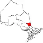 | |
|---|---|---|
| Towns | ||
| Townships | ||
| Village | ||
| Indian Reserves | ||
| Unorganized areas | ||
| Local services boards | ||
| ||
This article is issued from Wikipedia. The text is licensed under Creative Commons - Attribution - Sharealike. Additional terms may apply for the media files.
