Gauthier, Ontario
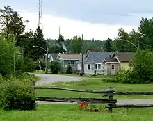
Gauthier is a township municipality in Timiskaming District the Northeastern Ontario, Canada.[1] The township had a population of 138 in the Canada 2016 Census. Its main population centre is Dobie, located just north of Ontario Highway 66, 18.5 kilometres (11.5 mi) east of Kirkland Lake. The township has just one other named place, Northlands Park, 3.7 kilometres (2.3 mi) west of Dobie on Ontario Highway 672 just north of Highway 66.[3][4]
Gauthier | |
|---|---|
| Township of Gauthier | |
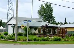 Gauthier Community Hall in Dobie | |
 Gauthier Location in Ontario | |
| Coordinates: 48°08′45″N 79°49′21″W[1] | |
| Country | Canada |
| Province | Ontario |
| Region | Northeastern Ontario |
| District | Timiskaming |
| Government | |
| • Type | Township |
| • Reeve | Marie Savarie |
| • Federal riding | Timmins—James Bay |
| • Prov. riding | Timiskaming—Cochrane |
| Area | |
| • Land | 88.41 km2 (34.14 sq mi) |
| Population (2016)[2] | |
| • Total | 138 |
| • Density | 1.6/km2 (4/sq mi) |
| Time zone | UTC-5 (Eastern Time Zone) |
| • Summer (DST) | UTC-4 (Eastern Daylight Time) |
| Postal Code | P0K 1B0 |
| Area code(s) | 705, 249 |
History
Dobie housed the miners working the Upper Canada Mines, which produced 4,648,984 ounces of gold before closing in 1971.[5]
Demographics
| Canada census – Gauthier, Ontario community profile | |||
|---|---|---|---|
| 2016 | 2011 | ||
| Population: | 138 (12.2% from 2011) | 123 (-7.5% from 2006) | |
| Land area: | 88.41 km2 (34.14 sq mi) | 88.59 km2 (34.20 sq mi) | |
| Population density: | 1.6/km2 (4.1/sq mi) | 1.4/km2 (3.6/sq mi) | |
| Median age: | 50.0 (M: 51.5, F: 48.0) | 45.9 (M: 46.5, F: 45.7) | |
| Total private dwellings: | 79 | 69 | |
| Median household income: | $72,576 | ||
| References: 2016[6] 2011[7] earlier[8] | |||
| Year | Pop. | ±% |
|---|---|---|
| 1986 | 152 | — |
| 1991 | 149 | −2.0% |
| 1996 | 152 | +2.0% |
| 2001 | 128 | −15.8% |
| 2006 | 133 | +3.9% |
| 2011 | 123 | −7.5% |
| 2016 | 138 | +12.2% |
| [9][10][2] | ||
Private dwellings, excluding seasonal cottages: 62 (total: 79).[2]
Mother tongue (2006):[11]
- English as first language: 85%
- French as first language: 7.5%
- English and French as first language: 7.5%
- Other as first language: 0%
Transportation
Gauthier is served by two provincial highways:[12]
- Ontario Highway 66 running west to Kirkland Lake and Ontario Highway 11, and east to the Quebec border, where it continues as Quebec Route 117. Highway 66 is part of the Trans-Canada Highway between highway 11 and the Quebec border.
- Ontario Highway 672, running north from Highway 66 past Northlands Park to Esker Lakes Provincial Park and then to Ontario Highway 101.
The township is traversed in an east–west direction by the Nipissing Central Railway line that runs between Swastika (Ontario) and Rouyn-Noranda (Quebec). The line continues to be operated, as a subsidiary of the Ontario Northland Railway, as a freight spur.[13]
Notable people
Actress Sara Botsford was born in Dobie.
References
- "Gauthier". Geographical Names Data Base. Natural Resources Canada. Retrieved 2020-07-08.
- "Census Profile, 2016 Census: Gauthier, Township". Statistics Canada. Retrieved July 18, 2019.
- "Ontario Geonames GIS (on-line map and search)". Ontario Ministry of Natural Resources and Forestry. 2014. Retrieved 2020-07-08.
- "Toporama (on-line map and search)". Atlas of Canada. Natural Resources Canada. Retrieved 2020-07-08.
- Barnes, Michael (1995). Gold in Ontario. Erin: The Boston Mills Press. p. 35. ISBN 155046146X.
- "2016 Community Profiles". 2016 Canadian Census. Statistics Canada. February 21, 2017. Retrieved 2020-12-18.
- "2011 Community Profiles". 2011 Canadian Census. Statistics Canada. July 5, 2013. Retrieved 2020-12-18.
- "2001 Community Profiles". 2001 Canadian Census. Statistics Canada. February 17, 2012.
- Statistics Canada: 1996, 2001, 2006, 2011 census
- 2011 Census Profile
- "2006 Community Profile".
- Map 13 (PDF) (Map). 1 : 1,600,000. Official road map of Ontario. Ministry of Transportation of Ontario. 2018-01-01. Retrieved 2020-07-08.
- "Freight". Ontario Northland. Retrieved 2020-07-08.
External links
![]() Media related to Gauthier, Ontario at Wikimedia Commons
Media related to Gauthier, Ontario at Wikimedia Commons
Places adjacent to Gauthier, Ontario | |
|---|---|
| City | 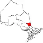 | |
|---|---|---|
| Towns | ||
| Townships | ||
| Village | ||
| Indian Reserves | ||
| Unorganized areas | ||
| Local services boards | ||
| ||
