Matachewan
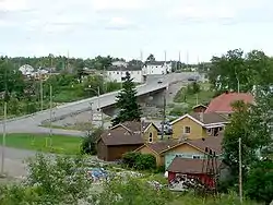
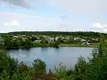
Matachewan is a township in Timiskaming, Northeastern Ontario, Canada, located at the end of Ontario Highway 66 along the Montreal River. The name is derived from the Cree word for "meeting of the currents".[2]
Matachewan | |
|---|---|
| Township of Matachewan | |
 | |
| Motto(s): Where the highway ends... the adventure begins! | |
 Matachewan | |
| Coordinates: 48°00′N 80°39′W | |
| Country | Canada |
| Province | Ontario |
| District | Timiskaming |
| Incorporated | 1995 |
| Government | |
| • Type | Township |
| • Reeve | Anne Commando-Dubé |
| • Federal riding | Timmins—James Bay |
| • Prov. riding | Timiskaming—Cochrane |
| Area | |
| • Land | 543.58 km2 (209.88 sq mi) |
| Population (2016)[1] | |
| • Total | 225 |
| • Density | 0.4/km2 (1/sq mi) |
| Time zone | UTC-5 (EST) |
| • Summer (DST) | UTC-4 (EDT) |
| Postal Code | P0K 1M0 |
| Area code(s) | 705 |
| Website | www |
The town's main economy is based on mineral mining, mainly gold mining, with some tourism.
History
Matachewan began as a trading post of the Hudson's Bay Company, called Fort Matachewan, located about 8 kilometres (5.0 mi) north of the present town site. It consisted only of a large depot and stores, with a church added later on. The local First Nations, who traded their furs here, would camp along the Montreal River but not settle permanently.[3]
Jack Davidson discovered gold in 1916 and teamed up with Weldy Young in 1930 to start the Young Davidson Mines. Sam Otisse staked a claim next to Davidson in 1917, which became the Matachewan Consolidated Mines. Alex Mosher staked claims which became the Ashley Gold Mine (1932-1936).[4]
The impetus to the town's growth came in the 1920s when mineral deposits, such as gold, copper, and molybdenite, were found in the area. From then on it experienced boom and bust cycles of typical mining towns, depending on the swings in commodity prices, but its economy has gradually shifted to forestry and tourism.[3]
In January 1976, the Improvement District of Matachewan was formed, and in 1995, it was incorporated as a township.
The Otisse Lake overflowed into mine tailings on 17 Oct. 1990, and 170,000 cubic metres of mine slimes entered the Matachewan River.[4]
In 2006, a medivac helipad was built to help accommodate the possibility of injuries that may occur at the Young-Davidson mine site. In 2008, an old and worn out wooden bridge over the Montreal River which was built in 1937 was replaced with a new steel-concrete reinforced structure for safety reasons regarding the heavy traffic to/from the mine.[5]
Geology
Matachewan is on the southwest portion of the Abitibi greenstone belt and within the Abitibi gold belt. Between 1933 and 1957, the Young-Davidson Mine and the Matachewan Consolidated Mine produced 9.6 million tonnes of ore containing 3.1 grams of gold per ton and 0.93 grams per ton of silver. Between 1979 and 1980, Pamour Porcupine Mines Limited open-pit mining produced 18,000 tonnes of ore containing more than 3.4 grams per ton of gold.[6]
Demographics
| Year | Pop. | ±% |
|---|---|---|
| 1986 | 491 | — |
| 1991 | 453 | −7.7% |
| 1996 | 402 | −11.3% |
| 2001 | 308 | −23.4% |
| 2006 | 375 | +21.8% |
| 2011 | 409 | +9.1% |
| 2016 | 225 | −45.0% |
| Statistics Canada[7][8][1] | ||
| Canada census – Matachewan community profile | |||
|---|---|---|---|
| 2016 | 2011 | 2006 | |
| Population: | 225 (-45.0% from 2011) | 409 (9.1% from 2006) | 375 (21.8% from 2001) |
| Land area: | 543.58 km2 (209.88 sq mi) | 543.63 km2 (209.90 sq mi) | 543.63 km2 (209.90 sq mi) |
| Population density: | 0.4/km2 (1.0/sq mi) | 0.75/km2 (1.9/sq mi) | 0.7/km2 (1.8/sq mi) |
| Median age: | 52.7 (M: 52.2, F: 52.9) | 50.8 (M: 48.0, F: 52.5) | |
| Total private dwellings: | 166 | 260 | 217 |
| Median household income: | $57,216 | ||
| Notes: 2011 population and housing figures corrected.[7] – References: 2016[9] 2011[10] 2006[11] earlier[12] | |||
Culture
Matachewan is known for celebrating local cultures every July during the Matachewan Villages Festival event.
See also
References
- "Census Profile, 2016 Census: Matachewan, Township". Statistics Canada. Retrieved July 17, 2019.
- Hamilton, William (1978). The Macmillan Book of Canadian Place Names. Toronto: Macmillan. p. 158. ISBN 0-7715-9754-1.
- "About Matachewan". Township of Matachewan. Archived from the original on January 7, 2009. Retrieved 2009-07-31.
- Barnes, Michael (1995). Gold in Ontario. Erin: The Boston Mills Press. pp. 62–63. ISBN 155046146X.
- Perry Kong (April 30, 2007). "The Community Where Adventure Begins" (PDF). Northern News. Archived from the original (PDF) on February 23, 2014. Retrieved February 9, 2012.
- Powell, W.G.; Kilbourne, M.W.; Hodgson, C.J. (1991). "Gold Related Geology of the Matachewan Camp". Society of Economic Geologists. Archean Gold Deposits of the Matachewan-Kirkland Lake-Larder Lake Area, Ontario, Canada (Guidebook Series Vol. II): 72.
- "Corrections and updates". Statistics Canada. 2012-10-24. Retrieved 2012-11-11.
- 1996, 2001, 2006, 2011 census
- "2016 Community Profiles". 2016 Canadian Census. Statistics Canada. February 21, 2017. Retrieved 2019-07-17.
- "2011 Community Profiles". 2011 Canadian Census. Statistics Canada. July 5, 2013. Retrieved 2014-02-04.
- "2006 Community Profiles". 2006 Canadian Census. Statistics Canada. March 30, 2011. Retrieved 2014-02-04.
- "2001 Community Profiles". 2001 Canadian Census. Statistics Canada. February 17, 2012.
External links
| Wikimedia Commons has media related to Matachewan, Ontario. |
Places adjacent to Matachewan | |
|---|---|
| City | 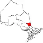 | |
|---|---|---|
| Towns | ||
| Townships | ||
| Village | ||
| Indian Reserves | ||
| Unorganized areas | ||
| Local services boards | ||
| ||
