Harley, Ontario
Harley is a township in the Canadian province of Ontario. Located within the Timiskaming District, Harley is located directly north of the city of Temiskaming Shores.
- For the community with the same name in Burford Township, see: Harley, Brant County, Ontario.
Harley | |
|---|---|
| Township of Harley | |
 | |
 Harley | |
| Coordinates: 47°37′N 79°42′W | |
| Country | Canada |
| Province | Ontario |
| District | Timiskaming |
| Established | 1896 |
| Incorporated | 1904 |
| Government | |
| • Type | Township |
| • Reeve | Pauline Archambault |
| • Federal riding | Timmins—James Bay |
| • Prov. riding | Timiskaming—Cochrane |
| Area | |
| • Land | 92.3 km2 (35.6 sq mi) |
| Population (2016)[1] | |
| • Total | 551 |
| • Density | 6.0/km2 (16/sq mi) |
| Time zone | UTC-5 (EST) |
| • Summer (DST) | UTC-4 (EDT) |
| Postal Code | P0J 1P0 |
| Area code(s) | 705 |
| Website | harley |
It is believed to be named in honour of Archibald Harley, former Member of Parliament for Oxford South.[2]
Arnold Peters, a Member of Parliament from 1957 to 1980, was born in Uno Park.
Communities
The township's main settlement is the community of Hanbury. The ghost town of Uno Park is also located within the township.
History
In 1896, the township was opened up for settlement. Settlers arrived first by boat on the Wabi Creek and later on via the North Dymond and Harley Road (since 1937 known as Highway 11). It was incorporated in 1904.[2]
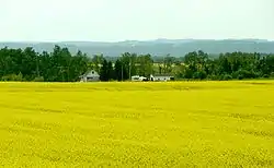
Initially the land was covered with spruce, tamarack, cedar, and poplar, that supported a thriving lumber industry. Having been cleared of most forests, Harley's main economic activity shifted to agriculture.[2]
Demographics
| Canada census – Harley, Ontario community profile | |||
|---|---|---|---|
| 2016 | 2011 | ||
| Population: | 551 (2.2% from 2011) | 539 (-2.2% from 2006) | |
| Land area: | 92.30 km2 (35.64 sq mi) | 91.73 km2 (35.42 sq mi) | |
| Population density: | 6.0/km2 (16/sq mi) | 5.9/km2 (15/sq mi) | |
| Median age: | 42.2 (M: 40.9, F: 43.0) | 42.6 (M: 41.2, F: 43.7) | |
| Total private dwellings: | 216 | 205 | |
| Median household income: | $72,448 | ||
| References: 2016[3] 2011[4] earlier[5] | |||
| Year | Pop. | ±% |
|---|---|---|
| 1986 | 596 | — |
| 1991 | 603 | +1.2% |
| 1996 | 608 | +0.8% |
| 2001 | 557 | −8.4% |
| 2006 | 551 | −1.1% |
| 2011 | 539 | −2.2% |
| 2016 | 551 | +2.2% |
| [6][7][1] | ||
Private dwellings, excluding seasonal cottages: 209 (total: 216).[1]
Mother tongue (2006):[8]
- English as first language: 60.5%
- French as first language: 39.5%
- English and French as first language: 0%
- Other as first language: 0%
References
- "Census Profile, 2016 Census: Harley, Township". Statistics Canada. Retrieved July 17, 2019.
- "History". Township of Harley. Retrieved 2009-07-28.
- "2016 Community Profiles". 2016 Canadian Census. Statistics Canada. February 21, 2017. Retrieved 2020-12-18.
- "2011 Community Profiles". 2011 Canadian Census. Statistics Canada. July 5, 2013. Retrieved 2020-12-18.
- "2001 Community Profiles". 2001 Canadian Census. Statistics Canada. February 17, 2012.
- Statistics Canada: 1996, 2001, 2006, 2011 census
- 2011 Census Profile
- "2006 Community Profile".
External links
| Wikimedia Commons has media related to Harley, Ontario. |
Places adjacent to Harley, Ontario | |
|---|---|
| City | 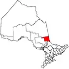 | |
|---|---|---|
| Towns | ||
| Townships | ||
| Village | ||
| Indian Reserves | ||
| Unorganized areas | ||
| Local services boards | ||
| ||