Larder Lake, Ontario
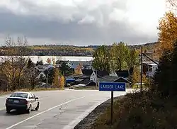
Larder Lake is an incorporated municipal township[1] and eponymous constituent dispersed rural community[4] in Timiskaming District in Northeastern Ontario, Canada. It is located along Ontario Highway 66 and Ontario Highway 624 at the north-western part of the lake bearing the same name.[5][6][7] The area of the township is 229.65 km2 (88.67 sq mi)[8] and includes the geographic townships of Hearst, McVittie and Skead.[5]
Larder Lake | |
|---|---|
| Township of Larder Lake | |
 Larder Lake | |
 Larder Lake | |
| Coordinates: 48°06′00″N 79°43′00″W[1] | |
| Country | Canada |
| Province | Ontario |
| District | Timiskaming |
| Established | 1907 |
| Government | |
| • Type | Township |
| • Mayor | Patricia Quinn |
| • MP | Charlie Angus |
| • MPP | John Vanthof |
| Area | |
| • Total | 229.52 km2 (88.62 sq mi) |
| Elevation | 299 m (981 ft) |
| Population (2016)[2] | |
| • Total | 730 |
| • Density | 3.2/km2 (8/sq mi) |
| Time zone | UTC-5 (EST) |
| • Summer (DST) | UTC-4 (EDT) |
| Postal code span | P0K |
| Area code(s) | 705, 249 |
| Website | www |
Located within the "Larder Lake-Cadillac Fault Zone", a geologic region rich in precious metals, the town was the site of the first gold rush in northeastern Ontario.
History
The discovery of silver in Cobalt, Ontario in 1903 led prospectors to search across northern Ontario for new finds. The discovery of gold led to 4,000 claims by the winter of 1906 and the eventual development of the Omega (1936-1947), Chesterville (1938-1952), and Kerr Addison gold mines (started in 1936).[9][10]
H.L. Kerr explored the Larder Lake area in 1904, but did not find gold. He returned with his partner Bill Addison in 1906, and discovered traces of gold near the north arm of Larder Lake, next to Robert Reddick's claims. Within months, 40 gold mining companies were established, and there was tremendous optimism and financial speculation. A mining investment company published an advertisement in the Ottawa Citizen in 1907 stating: "The Larder Lake district is believed to be the richest gold country ever known, and it is just now being opened up. Soon will commence the most tremendous outpouring of gold known to civilization."[11] Three-thousand men made their way to the area via canoe and portage to look for work, settling in a camp known as "Larder City". Excitement led to disappointment, as no large deposits of gold were found, and most of the town was abandoned by 1911. A mine brought into production between 1907 and 1911 was able to produce just $314 worth of gold, though that small output was used to mint Canada's first $5 gold pieces.[12][10]
In 1936, a large gold deposit was discovered in Larder Lake, leading to the establishment of several productive mines.[13]
Ontario Highway 66 was built in the 1930s to connect the various mining towns in the region. The highway connected Larder Lake to Kirkland Lake in the west, and to other mining communities to the east. The section between Kirkland Lake and Larder Lake was paved in 1944.[14]
In 1937, a boat traveling across Larder Lake to Miller Island on a fishing expedition capsized, killing all 7 on board. Searchers discovered the boat filled with water, and slowly began to recover bodies.[15] The boat's captain, John C. Skinner, Chief Engineer of the Lake Shore Mining Company, had been warned by a forest ranger that the weather conditions were too dangerous for the journey.
The Lakeshore Hotel was destroyed by fire in 1938. Guests lost all their belongings, though no injuries were reported.[16]
By 1941, labourers at Larder Lake's Omega Gold Mine were earning $4.64 per day, and the mine captain was earning $8.70 per day.[17] Omega was awarded the John T. Ryan Trophy in 1943 by the Canadian Institute of Mining, Metallurgy and Petroleum for having the lowest accident frequency in Canada during the previous year.
The Catholic church in Larder Lake caught fire in 1947, just moments after Sunday mass. No injuries were reported, though all sacred vessels, organ drapes, vestments and pews were destroyed.[18]
In 1952, the Larder Lake Fire Department took first place in a regional competition of the Timiskaming Firemen's Association, beating 22 other fire brigades.[19]
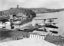
Larder Lake's train station, located north-east of the town, was the site of a large robbery in 1965. Five gold bars worth $165,000 were awaiting shipment to the mint in Ottawa, when 4 armed men broke in. A float plane in Larder Lake was believed used in the getaway.[20]
A damaging storm moved through northeastern Ontario on July 17, 2006, bringing with it winds of 120 km/h (75 mph) to 150 km/h (93 mph). Approximately 1,904 ha (4,700 acres) of forest southwest of Larder Lake suffered blowdown.[21]
The 2010 Winter Olympics torch relay passed through Larder Lake on January 1, 2010.
Demographics
| Canada census – Larder Lake, Ontario community profile | |||
|---|---|---|---|
| 2016 | 2011 | ||
| Population: | 730 (6.7% from 2011) | 684 (-6.9% from 2006) | |
| Land area: | 229.52 km2 (88.62 sq mi) | 229.65 km2 (88.67 sq mi) | |
| Population density: | 3.2/km2 (8.3/sq mi) | 3.0/km2 (7.8/sq mi) | |
| Median age: | 50.9 (M: 50.8, F: 51.0) | 52.4 (M: 53.7, F: 50.8) | |
| Total private dwellings: | 466 | 519 | |
| Median household income: | $60,459 | ||
| References: 2016[22] 2011[23] earlier[24] | |||
| Year | Pop. | ±% |
|---|---|---|
| 1986 | 1,091 | — |
| 1991 | 1,030 | −5.6% |
| 1996 | 982 | −4.7% |
| 2001 | 790 | −19.6% |
| 2006 | 735 | −7.0% |
| 2011 | 684 | −6.9% |
| 2016 | 730 | +6.7% |
| [8][2] | ||
The township had a population of 730 in the Canada 2016 Census. Private dwellings, excluding seasonal cottages: 351 (total: 466)
| First language[25] | Percent of population |
|---|---|
| English | 61.1 |
| French | 33.6 |
| English and French | 1.3 |
| Other | 4.0 |
See also
- Larder Lake
- Dobie, Ontario - community to the west of Larder Lake
- Virginiatown, Ontario - community to the east of Larder Lake
- List of townships in Ontario
- List of francophone communities in Ontario
References
- "Larder Lake". Geographical Names Data Base. Natural Resources Canada. Retrieved 2014-05-19. (municipal township)
- "Census Profile, 2016 Census: Larder Lake, Township". Statistics Canada. Retrieved July 17, 2019.
- Elevation taken from Google Earth at geographical coordinates, accessed 2014-05-20.
- "Larder Lake". Geographical Names Data Base. Natural Resources Canada. Retrieved 2017-12-17. (community)
- "CLAIMaps IV". Ontario Ministry of Northern Development and Mines. 2016. Retrieved 2017-12-17.
- Map 15 (PDF) (Map). 1 : 1,600,000. Official road map of Ontario. Ministry of Transportation of Ontario. 2016-01-01. Retrieved 2017-12-17.
- Restructured municipalities - Ontario map #4 (Map). Restructuring Maps of Ontario. Ontario Ministry of Municipal Affairs and Housing. 2006. Retrieved 2017-12-17.
- 2011 Census Profile
- Pain, S.A. (1960). Three Miles of Gold. Toronto: The Ryerson Press. pp. 2–6.
- Barnes, Michael (1995). Gold in Ontario. Erin: The Boston Mills Press. pp. 33–36. ISBN 155046146X.
- "Larder Lake: The Golden North and the Golden Opportunity". Ottawa Citizen. April 26, 1907.
- Barnes, Michael (1998). Great Northern Ontario Mines. General Store Publishing. ISBN 9781896182858.
- Savage, W.S. (1964). "MINERAL RESOURCES AND MINING PROPERTIES IN THE KIRKLAND LAKE - LARDER LAKE MINING AREA" (PDF). Ontario Department of Mines.
- "The King's Highway 66". Cameron Bevers.
- "Take Second Body from Larder Lake". Ottawa Citizen. Oct 14, 1932.
- "Larder Lake Hotel Burns, Guests Lose Belongings". Ottawa Citizen. Jan 25, 1938.
- Barnes, Michael (April 1, 2011). "Life in Kirkland Lake During World War II". Republic of Mining.
- "Larder Lake Church Burns". Windsor Daily Star. Sep 15, 1947.
- "Larder Lake Tops in Fire Tourney with Ladder Race, Parade First". Val d'Or Star. July 4, 1952.
- "Thieves in Ontario get $164,000 in Gold Bars". The StarPhoenix. June 12, 1965.
- "Forest Health Conditions in Ontario, 2006" (PDF). Ministry of Natural Resources (Ontario). 2007.
- "2016 Community Profiles". 2016 Canadian Census. Statistics Canada. February 21, 2017. Retrieved 2020-12-23.
- "2011 Community Profiles". 2011 Canadian Census. Statistics Canada. July 5, 2013. Retrieved 2020-12-23.
- "2001 Community Profiles". 2001 Canadian Census. Statistics Canada. February 17, 2012.
- "2006 Community Profile".
External links
| Wikimedia Commons has media related to Larder Lake, Ontario. |
Places adjacent to Larder Lake, Ontario | |
|---|---|
| City | 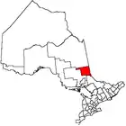 | |
|---|---|---|
| Towns | ||
| Townships | ||
| Village | ||
| Indian Reserves | ||
| Unorganized areas | ||
| Local services boards | ||
| ||