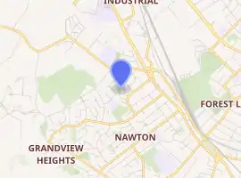
Crawshaw, New Zealand
Crawshaw is a compact suburb, close to Te Rapa railway depot, in western Hamilton in New Zealand,[1] and extended in the 2018 census to cover 0.86 km2 (210 acres).[2] Although sometimes referred to as a suburb in its own right,[3] it is often described as being part of Nawton.[4][5][6]
Crawshaw | |
|---|---|
Suburb | |
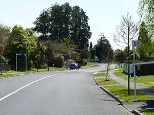 A neighbourhood in Crawshaw, Hamilton. | |
| |
| Country | New Zealand |
| Local authority | Hamilton, New Zealand |
| Electoral ward | Hamilton West |
| Population (2018 Census) | |
| • Total | 3,249 |
| Te Rapa | ||
| Rotokauri |
|
Forest Lake |
| Nawton |
The southern part of the suburb was developed about 1913,[7][8] but the northern in the 1960s[9] and 1970s.[10] Housing New Zealand properties, tenanted by low income families have been reported to make up a majority of homes.[11]
Crawshaw Park was created between 1979 and 1985. It covers 3.1 ha (7.7 acres), includes some remnant kahikateas and forms a link in a green chain through Mooney Park, Bishops Lane Reserve, Crawshaw Park and Dominion Park.[12]
Demographics
| Year | Pop. | ±% p.a. |
|---|---|---|
| 2006 | 2,892 | — |
| 2013 | 2,889 | −0.01% |
| 2018 | 3,249 | +2.38% |
| Source: [13] | ||
Crawshaw had a population of 3,249 at the 2018 New Zealand census, an increase of 360 people (12.5%) since the 2013 census, and an increase of 357 people (12.3%) since the 2006 census. There were 960 households. There were 1,593 males and 1,656 females, giving a sex ratio of 0.96 males per female. The median age was 26.9 years, with 957 people (29.5%) aged under 15 years, 873 (26.9%) aged 15 to 29, 1,227 (37.8%) aged 30 to 64, and 192 (5.9%) aged 65 or older.
Ethnicities were 52.0% European/Pākehā, 50.2% Māori, 11.8% Pacific peoples, 8.3% Asian, and 2.9% other ethnicities (totals add to more than 100% since people could identify with multiple ethnicities).
The proportion of people born overseas was 13.9%, compared with 27.1% nationally.
Although some people objected to giving their religion, 55.7% had no religion, 28.9% were Christian, 3.0% were Hindu, 1.1% were Muslim, 0.6% were Buddhist and 4.8% had other religions.
Of those at least 15 years old, 207 (9.0%) people had a bachelor or higher degree, and 552 (24.1%) people had no formal qualifications. The median income was $23,800. The employment status of those at least 15 was that 1,092 (47.6%) people were employed full-time, 264 (11.5%) were part-time, and 243 (10.6%) were unemployed.[13]
Crawshaw census area had a block of about 25 houses from Nawton East added in 2018.[2] The population increased by about a quarter from 1996 to 2018. They are poorer and younger than the 37.4 years of the national average, with more than double Hamilton's Māori average of 23.7%.[14] The table below uses the older, slightly smaller census area for the older figures.-[15]
| Year | Population | Average age | Households | Median income | National median income |
|---|---|---|---|---|---|
| 1996 | 2,541 | 780[16] | |||
| 2001 | 2,874 | 24.7 | 897 | $16,100 | $18,500 |
| 2006 | 2,838 | 25.3 | 912 | $21,900 | $24,100 |
| 2013 | 2,796[17] (2,889)[15] | 26.1 | 906 | $22,600 | $27,900[17] |
| 2018 | 3,249 | 26.9 | 963 | $23,800 | $31,800 |
Education
Crawshaw School is a coeducational state primary school for years 1 to 8, with a roll of 294 as of March 2020.[18][19] The school opened in 1988.[20]
References
- "Hamilton Map". Hamilton City Council. Archived from the original on 23 September 2010. Retrieved 18 September 2010.
- "Geographic Boundary Viewer". statsnz.maps.arcgis.com. Retrieved 4 April 2020.
- "Game on for new Crawshaw sports court". www.hamilton.govt.nz. Retrieved 4 April 2020.
- "Odlin Crescent". ketehamilton.peoplesnetworknz.info. Retrieved 4 April 2020.
- "Crawshaw School - 07/09/2018". Education Review Office. Retrieved 4 April 2020.
- "Property details for 35A Crawshaw Drive, Nawton, Hamilton, 3200". www.qv.co.nz. Retrieved 4 April 2020.
- "Sunnyside Road". ketehamilton.peoplesnetworknz.info. Retrieved 4 April 2020.
- "Breckons Avenue". ketehamilton.peoplesnetworknz.info. Retrieved 4 April 2020.
- "Mooney Street". ketehamilton.peoplesnetworknz.info. Retrieved 4 April 2020.
- "Odlin Crescent". ketehamilton.peoplesnetworknz.info. Retrieved 4 April 2020.
- "Fight to make Crawshaw playground safe for kids". Stuff. Retrieved 4 April 2020.
- "Neighbourhood and Amenity Reserves Management Plan" (PDF). Hamilton City Council. May 2007.
- "Statistical area 1 dataset for 2018 Census". Statistics New Zealand. March 2020. Crawshaw (176800). 2018 Census place summary: Crawshaw
- "2018 Census place summaries | Hamilton". www.stats.govt.nz. Retrieved 4 April 2020.
- "2018 Census place summaries | Crawshaw". www.stats.govt.nz. Retrieved 4 April 2020.
- "2006 Census of Population and Dwellings - Hamilton City". Stats NZ.
- "2013 Census map – QuickStats about a place". archive.stats.govt.nz. Retrieved 4 April 2020.
- "New Zealand Schools Directory". New Zealand Ministry of Education. Retrieved 26 April 2020.
- Education Counts: Crawshaw School
- Tantau, Kelley (22 February 2018). "Hamilton teachers witness life, love, death in school's 30 years". Waikato Times.