Rototuna
Rototuna is a suburb in northern Hamilton, New Zealand, east of Flagstaff. It is one of the newest and fastest-growing suburbs in Hamilton, along with neighbouring Huntington and Flagstaff.
Rototuna | |
|---|---|
Suburb | |
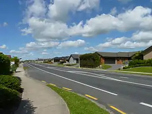 Thomas Road, Rototuna | |
| |
| Country | New Zealand |
| Local authority | Hamilton |
| Population (2018 census | |
| • Total | 13,791 |
| Postcode(s) | 3210 |
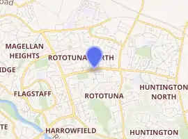
| Magellan Rise | Horsham Downs | Gordonton |
| Flagstaff |
|
St James Park |
| Harrowfield | Chartwell | Huntington |
Sometimes the name Rototuna is used to collectively refer to all of the city north of Wairere Drive and east of the Waikato River, including Flagstaff, St Petersburg, Magellan Rise, Ashmore, Somerset Heights, St James, Callum Brae and Huntington.[1]
Although many Hamilton City publications say it was built on what was previously the bed of an ancient lake of which Rototuna was a tiny remnant,[2] Lake Tunawhakapeka was to the north in Horsham Downs.[3] However, its alternative name of Lake Rototuna, was the inspiration for the name given to a new post office in 1907 and later adopted for the area.[4] The New Zealand Ministry for Culture and Heritage gives a translation of "eel lake" for Rototuna.[5]
History
Carbon dating of 1550 to 1625 was put on charcoal from a cultivation ground, which was uncovered on the corner of Hukanui Road and Wairere Drive in 1999.[6]
Until around 1915[6] Rototuna Lake was described as "an ornament", but by 1919[7] it had been largely drained. It lay to the north[8] of Rototuna, in Horsham Downs.[7] Further drainage was done in 1926[9] and the lake bed was given to surrounding farms in 1928.[10] It remained as Lake E, more recently given its original name of Lake Tunawhakapeka, where the peat deposits date back over 17,000 years.[8] Like most of Waikato it would have been inundated by a flood of water and ignimbrite debris from Lake Taupo about 22,000 years ago.[11] The remaining lake is a metre deep and covers 6.7 ha (17 acres).[12] Lake Tunawhakapeka is said to have been 600 acres (240 ha).[4]
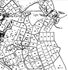
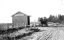
Like most of western Waikato the land at Rototuna was confiscated following the 1863 invasion of the Waikato. It was surveyed into 50-acre parcels as grants to militiamen of the Fourth Waikato Regiment.[13] By 1880[14] enough farmers had settled to be worth forming a school committee for the 30 children,[15] which opened as Kirikiriroa School in 1881.[16] The school was renamed Rototuna in 1907[17] and enlarged in 1914.[18] More development came in the 1900s, with a post office[19] and a church in 1907,[20] a store in 1910,[21] a casein factory in 1913[22] and a grocery and butcher in 1914.[23] Rototuna Road was gravelled[24] in 1909,[25] but it was still muddy enough to cause a death in 1916[26] and complaints were still being made in 1920.[27] Electricity came to the area about 1922.[28] The post office was replaced by rural delivery before 1926.[4] Another church opened in 1931[29] and a hall was open at about the same time.[30] The school closed between 1944[31] and 1963.[4] Its site is now occupied by a church.[32] The old dairy factory was used as a chocolate factory until 2017.[33]
Geography
Rototuna is mainly in the Kirikiriroa Stream valley.[34] It ranges from 35 m (115 ft) to 62 m (203 ft) above sea level.[35]
Demographics
| Year | Pop. | ±% p.a. |
|---|---|---|
| 2006 | 7,137 | — |
| 2013 | 11,841 | +7.50% |
| 2018 | 13,791 | +3.10% |
| Source: [36] | ||
Rototuna, comprising the statistical areas of Rototuna North, Rototuna Central, Te Manatu and Rototuna South, had a population of 13,791 at the 2018 New Zealand census, an increase of 1,950 people (16.5%) since the 2013 census, and an increase of 6,654 people (93.2%) since the 2006 census. There were 4,311 households. There were 6,693 males and 7,098 females, giving a sex ratio of 0.94 males per female, with 3,408 people (24.7%) aged under 15 years, 2,559 (18.6%) aged 15 to 29, 6,189 (44.9%) aged 30 to 64, and 1,629 (11.8%) aged 65 or older.
Ethnicities were 63.6% European/Pākehā, 11.0% Māori, 2.5% Pacific peoples, 28.9% Asian, and 4.4% other ethnicities (totals add to more than 100% since people could identify with multiple ethnicities).
The proportion of people born overseas was 36.9%, compared with 27.1% nationally.
Although some people objected to giving their religion, 45.0% had no religion, 36.9% were Christian, 4.6% were Hindu, 3.1% were Muslim, 1.4% were Buddhist and 3.9% had other religions.
Of those at least 15 years old, 3,339 (32.2%) people had a bachelor or higher degree, and 1,320 (12.7%) people had no formal qualifications. The employment status of those at least 15 was that 5,592 (53.9%) people were employed full-time, 1,425 (13.7%) were part-time, and 357 (3.4%) were unemployed.[36]
| Name | Population | Median age | Median income |
|---|---|---|---|
| Rototuna North | 912 | 30.5 years | $37,600 |
| Rototuna Central | 4,779 | 34.8 years | $39,000 |
| Te Manatu | 3,672 | 31.5 years | $39,400 |
| Rototuna South | 4,428 | 40.1 years | $34,400 |
| New Zealand | 37.4 years | $31.800 |
Rototuna's population has risen rapidly, from 453 in 1996 to 13,791 in 2018. Its median income remains above the national median, but the median age in the northern areas is below the national median age of 37.4 years in 2018.
In 2018 the main ethnic groups were -
| Area | European | Asian | Māori |
|---|---|---|---|
| North | 47.0% | 41.8% | 14.1% |
| Central | 64.9% | 28.8% | 10.7% |
| Te Manatu | 57.2% | 33.5% | 11.6% |
| South | 70.9% | 22.5% | 10.1% |
For censuses prior to 2018 Rototuna was formed of census areas for Rototuna (in 2018 largely renamed Rototuna South) and Horsham Downs (in 2018 forming Rototuna North and Central). Growth was initially to the south, then the north.
The population has grown in Rototuna North,[37] Central[38] and South[39] as in this table -
| North | Central (prior to 2018 Horsham Downs) | South (prior to 2018 Rototuna) | National median income | ||||||||||
|---|---|---|---|---|---|---|---|---|---|---|---|---|---|
| Year | Population | Median age | Households | Median income | Population | Median age | Households | Median income | Population | Median age | Households | Median income | |
| 1996 | prior to 2018 part of Horsham Downs | (192) | (261)[40] | ||||||||||
| 2001 | (843) | (30.9) | (282) | ($30,000) | (2,031) | (33.5) | (672) | ($28,500) | $18,500 | ||||
| 2006 | 126 | 2,463 (2,586) | (32.5) | (801) | ($34,000) | 3,891 (3,177) | (37.8) | (1,077) | ($32,100) | $24,100 | |||
| 2013 | 747 | 4,122 (4,833) | (32.5) | (1,491) | ($36,900) | 4,185 (3,195) | (40.6) | (1,125)[41] | ($33,900) | $27,900 | |||
| 2018 | 912 | 30.5 | 243 | $37,600 | 4,779 | 34.8 | 1,449 | $39,000 | 4,428 | 40.1 | 1,497 | $34,400 | $31,800 |
Facilities and Attractions
Rototuna has three shopping centres. Rototuna Shopping Centre has a New World supermarket, a BP petrol station, KFC, and Good Neighbour bar/restaurant.
St James Shopping Centre offers a Countdown supermarket, a Domino's Pizza outlet, a gym, McDonald's Restaurant and Palmers Planet Garden Centre.
The recently completed mixed-use development called Rototuna Village is a mixture of retail, hospitality, office and high end apartments. Tenants include - Lonestar, Harcourts Real Estate, Pita Pit, Liquorland, as well as a Fruit and Vege, Nutrition and specialty butcher.
Future plans for a Rototuna "town-centre" is included in council planning. This is to be located at the corner of Resolution Drive & Borman Road. It is likely to include community facilities such as a library and possibly a pool - although both of these may be shared with the High Schools.[42] $24m was proposed for library, pool and sports fields in the 2018 plan.[43] Completion is planned by 2022.[44]
Parks
Four large parks are being developed. Mangaiti Park, Te Manatu Park, Hare Puke Park and Rototuna Sports Parks.[45] Construction started at the Sports Park in 2018.[46] It was renamed Korokori Park in 2019[47] and officially opened in 2020.[48] It will have 5 pitches by 2021.[45] Hare Puke Park playground opened in 2018, with a theme of eels and the hinaki used to catch them.[49] Plans for Mangaiti Park Te Manatu Park were developed in 2015[45] and a playground opened at Mangaiti in 2019.[50] There are also smaller[51] parks at Eden Park Reserve, Moonlight Drive Reserve, Rototuna Park, Te Awa O Katapaki Esplanade, Te Toe Toe Reserve and Wiltshire Drive Reserve.[52]
Infrastructure
Roads
Rototuna roads have been enlarged from the previous country lane network since 2001, when the southern part of Resolution Drive was gazetted.[53] Extension to Borman Road cost $1.4m in 2004.[54] To be completed in 2021, Resolution Drive extension will link Rototuna to the Waikato Expressway to the north and the ring road at Wairere Drive to the south. The 1.9 km (1.2 mi) extension will cost $9.8m[55] and a benefit–cost ratio of 4.1% is expected.[56] East–west links are being provided by extension of Borman Rd (in 2006 it cost $840,000 to extend it to Cate Road)[54] and North City Rd at a further cost of about $21m.[57] All have two lanes and roundabouts.[55]
The main traffic flows are on the north–south roads; Gordonton, Horsham Downs and Resolution, with lesser flows east–west on Thomas Road.[58]
Buses
Buses on the Orbiter route serve Rototuna at 15 minute intervals.[58] The Orbiter route was lengthened to serve Rototuna in 2009.[59] The Rototuna Circular bus has provided a half hourly service[60] since 2018.[61] Bus 16 has linked Rototuna to the Transport Centre on a circuitous route via Callum Brae, at half hourly intervals,[62] since 2018.[63] Prior to 2009 that route was largely served by a Northerner bus from Chartwell.[64] School routes to St Paul's, Southwell, Peachgrove Intermediate, Hamilton Boys' High and Sacred Heart were added in 2016.[65]
Cycleways
3 m (9.8 ft) wide shared paths are being built beside Resolution Drive and Borman Rd[55] and $1m is being spent on cycleways, mostly running north–south on the eastern edge of Rototuna.[57]
Water
A 24 million litre reservoir opened at Kay Rd, beside the Expressway, in 2017. It is connected to the city's mains pipe network.[66]
Education
Rototuna Primary School and Te Totara Primary School are contributing primary schools (years 1–6) with rolls of 812 and 725 students respectively.[67][68] Rototuna Primary opened in 2003[69] and Te Totara opened in 2008.[70]
Rototuna Junior High School opened in early 2016 for the start of the school year which serves Years 7 to 10.[71] It cost $40m to build the school for 1,200 pupils.[72] Rototuna Senior High School opened in early 2017 for the start of the school year which serves Years 11 to 13.[71] The Junior & Senior high schools are based on the same grounds and share some facilities. The junior school has a roll of 1329 and the senior school has 731 students.[73][74]
Hamilton Christian School is a state-integrated non-denominational composite school for years 1 to 13 with a roll of 437.[75]
Waikato Waldorf School is a state integrated school providing Waldorf education from kindergarten to Year 10. It has a roll of 172.[76] The school opened in 1996.[77]
All these schools are coeducational. Rolls are as of March 2020.[78]
There are also many early childhood centres throughout the suburb.
See also
References
- "Rototuna Community Projects" (PDF). Hamilton City Council. 2019.
- "A warm welcome for city's newest sports park". Our Hamilton. 26 February 2020. Retrieved 26 April 2020.
- "Plan of the Military settlements in the Upper Waikato District". ap01.alma.exlibrisgroup.com. Retrieved 26 April 2020.
- "THE COUNTRYSIDE - WAIKATO TIMES". paperspast.natlib.govt.nz. 17 December 1926. Retrieved 26 April 2020.
- "1000 Māori place names". New Zealand Ministry for Culture and Heritage. 6 August 2019.
- Namtok Consultancy Ltd. (November 2011). "An Assessment Of The Potential Impact That Any Expansion And Development Of The Ruakura Estate Might Have On Cultural Values And Manawhenua" (PDF). Environmental Protection Agency.
- "DISTRICT NEWS - WAIKATO TIMES". paperspast.natlib.govt.nz. 18 March 1919. Retrieved 24 April 2020.
- ALAN G HOGG, DAVID J LOWE, and CHRIS H HENDY. "Radiocarbon, Vol, 29, No. 2, 1987, P 263-301] RADIOCARBON DATES" (PDF). University of Waikato.CS1 maint: multiple names: authors list (link)
- "GORDONTON. WAIKATO TIMES". paperspast.natlib.govt.nz. 7 April 1926. Retrieved 24 April 2020.
- "LAKE TUNAWHAKAPEKE. WAIKATO TIMES". paperspast.natlib.govt.nz. 20 February 1928. Retrieved 24 April 2020.
- Manville, V.; Hodgson, K. A.; Nairn, I. A. (June 2007). "A review of break‐out floods from volcanogenic lakes in New Zealand". New Zealand Journal of Geology and Geophysics. 50 (2): 131–150. doi:10.1080/00288300709509826. ISSN 0028-8306.
- Tracie Dean-Speirs & Keri Neilson (Waikato Regional Council) with input from Paula Reeves (Wildland Consultants) and Johlene Kelly (Alchemists Ltd.) (10 October 2014). "Waikato region shallow lakes management plan: Volume 2" (PDF). Waikato Regional Council.
- "WDC District Plan Review – Built Heritage Assessment - Historic Overview – Eastern Sector" (PDF). Waikato District Council. 2018.
- "WAIKATO DISTRICT NEWS. NEW ZEALAND HERALD". paperspast.natlib.govt.nz. 24 November 1880. Retrieved 24 April 2020.
- "Rototuna School Jubilee WAIKATO TIMES". paperspast.natlib.govt.nz. 14 March 1932. Retrieved 24 April 2020.
- "THE CAMBRIDGE LICENSING QUESTION. WAIKATO TIMES". paperspast.natlib.govt.nz. 19 February 1881. Retrieved 24 April 2020.
- "Board of Education. WAIKATO ARGUS". paperspast.natlib.govt.nz. 22 August 1907. Retrieved 24 April 2020.
- "BOARD OF EDUCATION - WAIKATO ARGUS". paperspast.natlib.govt.nz. 26 March 1914. Retrieved 24 April 2020.
- "Opening of the Rototuna Post Office. WAIKATO ARGUS". paperspast.natlib.govt.nz. 26 February 1907. Retrieved 24 April 2020.
- "Opening of the Rototuna Methodist Church. WAIKATO ARGUS". paperspast.natlib.govt.nz. 19 April 1907. Retrieved 24 April 2020.
- "Rototuna. WAIKATO ARGUS". paperspast.natlib.govt.nz. 26 March 1910. Retrieved 24 April 2020.
- "DISTRICT NEWS - WAIKATO ARGUS". paperspast.natlib.govt.nz. 10 December 1913. Retrieved 26 April 2020.
- "Rototuna. WAIKATO TIMES". paperspast.natlib.govt.nz. 20 April 1914. Retrieved 24 April 2020.
- "Kirikiriroa Road Board. WAIKATO ARGUS". paperspast.natlib.govt.nz. 3 October 1908. Retrieved 24 April 2020.
- "Rototuna. WAIKATO ARGUS". paperspast.natlib.govt.nz. 28 April 1909. Retrieved 24 April 2020.
- "ROTOTUNA MOTOR FATALITY - WAIKATO TIMES". paperspast.natlib.govt.nz. 19 December 1916. Retrieved 24 April 2020.
- "ROTOTUNA ROAD. WAIKATO TIMES". paperspast.natlib.govt.nz. 28 February 1920. Retrieved 24 April 2020.
- "DISTRICT NEWS - WAIKATO TIMES". paperspast.natlib.govt.nz. 11 October 1922. Retrieved 26 April 2020.
- "CHURCH AT ROTOTUNA. WAIKATO TIMES". paperspast.natlib.govt.nz. 15 April 1931. Retrieved 24 April 2020.
- "PRESENTATIONS. AUCKLAND STAR". paperspast.natlib.govt.nz. 19 April 1930. Retrieved 24 April 2020.
- "Ngaruawahia Sheet: N56". www.mapspast.org.nz. 1944. Retrieved 26 April 2020.
- "Cate Road". Google maps. Retrieved 26 April 2020.
- "Former Waikato Valley Chocolates factory site up for grabs". Stuff. Retrieved 26 April 2020.
- "Sheet: S14". www.mapspast.org.nz. 1998. Retrieved 24 April 2020.
- "Hamilton City – Water Distribution System Strategic Planning". webcache.googleusercontent.com. Retrieved 26 April 2020.
- "Statistical area 1 dataset for 2018 Census". Statistics New Zealand. March 2020. Rototuna North (175600), Rototuna Central (175900), Te Manatu (176100) and Rototuna South (176200). 2018 Census place summary: Rototuna North 2018 Census place summary: Rototuna Central 2018 Census place summary: Te Manatu 2018 Census place summary: Rototuna South
- "2018 Census place summaries". www.stats.govt.nz. Retrieved 8 April 2020.
- "2018 Census place summaries". www.stats.govt.nz. Retrieved 8 April 2020.
- "2018 Census place summaries". www.stats.govt.nz. Retrieved 8 April 2020.
- "2006 Census of Population and Dwellings - Hamilton City". Stats NZ.
- "2013 Census map – QuickStats about a place". archive.stats.govt.nz. Retrieved 12 March 2020.
- "Appendix 1.4.9 Rototuna Town Centre Design Guide - Hamilton City Council". www.hamilton.govt.nz. Retrieved 18 December 2016.
- "Rototuna and Northeast Hamilton Information" (PDF). Hamilton City Council.
- "Rototuna Community Hub project underway". Our Hamilton. 6 December 2018. Retrieved 21 April 2020.
- "Rototuna parks - Hamilton City Council". www.hamilton.govt.nz. Retrieved 21 April 2020.
- "Construction starts on new Rototuna sports park". Our Hamilton. 19 November 2018. Retrieved 21 April 2020.
- "Council AGENDA" (PDF). Hamilton City Council. 12 December 2019.
- "Korikori Park - Hamilton City Council". www.hamilton.govt.nz. Retrieved 24 April 2020.
- "Playgrounds - Hamilton City Council". www.hamilton.govt.nz. Retrieved 21 April 2020.
- "Playground Creations". www.facebook.com. Retrieved 21 April 2020.
- "Neighbourhood and Amenity Reserves Management Plan 2019" (PDF). Hamilton City Council.
- "Playgrounds - Hamilton City Council". www.hamilton.govt.nz. Retrieved 21 April 2020.
- "Land Declared Road-Resolution Drive, - 2001 - New Zealand Gazette". www.gazette.govt.nz. Retrieved 21 April 2020.
- "Hamilton Community Plan" (PDF). Hamilton City Council. 2004.
- "Roading project expected to unlock city's north-east". Stuff. Retrieved 21 April 2020.
- "Network Connections Summary Report - April 2013" (PDF). Hamilton City Council.
- "Rototuna" (PDF). Hamilton City Council.
- "2018 Traffic Flow Map" (PDF). Hamilton City Council.
- "GORDONTON. WAIKATO TIMES". paperspast.natlib.govt.nz. 7 April 1926. Retrieved 24 April 2020.
- "DISTRICT NEWS - WAIKATO TIMES". paperspast.natlib.govt.nz. 18 March 1919. Retrieved 24 April 2020.
- "Improved bus services roll out on eastern Hamilton routes". www.waikatoregion.govt.nz. 24 January 2018. Retrieved 14 April 2020.
- ALAN G HOGG, DAVID J LOWE, and CHRIS H HENDY. "Radiocarbon, Vol, 29, No. 2, 1987, P 263-301] RADIOCARBON DATES" (PDF). University of Waikato.CS1 maint: multiple names: authors list (link)
- Manville, V.; Hodgson, K. A.; Nairn, I. A. (June 2007). "A review of break‐out floods from volcanogenic lakes in New Zealand". New Zealand Journal of Geology and Geophysics. 50 (2): 131–150. doi:10.1080/00288300709509826. ISSN 0028-8306.
- "Transport Committee Agenda" (PDF). Hamilton City Council. 8 May 2007.
- "Demand for northern bus routes forces council's hand". Stuff. Retrieved 23 April 2020.
- Lance Haycock, Hamilton City Council & Johan Meintjes, Opus (2017). "Lessons in reservoir building". Water NZ.CS1 maint: multiple names: authors list (link)
- Education Counts: Rototuna Primary School
- Education Counts: Te Totara Primary School
- "About Us". Rototuna Primary School. Retrieved 15 October 2020.
- "Principal's Message". Te Totara Primary School. Retrieved 15 October 2020.
- "Welcome to Rototuna High Schools". Rototuna High Schools. Retrieved 15 October 2020.
- "Construction starts at new $40m Hamilton school". The Beehive. Retrieved 26 April 2020.
- Education Counts: Rototuna Junior High School
- Education Counts: Rototuna Senior High School
- Education Counts: Hamilton Christian School
- Education Counts: Waikato Waldorf School
- "About Steiner". Waikato Waldorf School. Retrieved 15 October 2020.
- "New Zealand Schools Directory". New Zealand Ministry of Education. Retrieved 26 April 2020.
