Hamilton East, New Zealand
Hamilton East is a suburb in central Hamilton in New Zealand. The suburb's primary commercial and retail precinct is located along Grey Street. Hamilton East is characterised by villas and bungalows built early in the 20th century.
Hamilton East | |
|---|---|
Suburb | |
 Hamilton East, viewed from Hamilton West. | |

| |
| Country | New Zealand |
| Local authority | Hamilton, New Zealand |
| Electoral ward | Hamilton East |
| Established | 1877 |
| Population (2018 Census) | |
| • Total | 12,996 |
| Hamilton Central | Claudelands | Ruakura |
| Hamilton West |
|
Hillcrest |
| Fitzroy | Peacocke |
History
Hamilton East is one of Hamilton's oldest suburbs. From the 1870s until the mid-20th century, Hamilton East was sometimes known as 'Irishtown'. A significant number of the militiamen who settled there were of Irish descent, and many other Irish Catholics came to live near the Catholic Church and convent.
The town of Hamilton East merged with Hamilton West in 1877. Many of the streets were named after famous figures of the New Zealand Wars, including Governor George Grey and Maori chief Te Awaitaia, who went by the name William Naylor/Wiremu Neera when he converted to Christianity.[1] Evidence of planning for the centre of the village can be seen in the village green concept of Steele Park and the planting of English trees along Grey Street. Hamilton East is one of the few suburbs of Hamilton to have a street grid plan.
Many of the parks in Hamilton East, including Hamilton Gardens, are located on the original Hamilton Town Belt that runs along the eastern and southern border of Hamilton East.[2] Just to the north of the Gardens, Flynn Park housed an ammunition factory from 1942 to 1946.[3] It is the most southerly of the parks in the original Belt[4] and on the edge of the Wairere Drive extension to Peacocke.[5]
In 2000 the suburb was extended over a former part of Ruakura Experimental Farm,[6] by Grasshopper East Ltd. and Chedworth Properties Ltd adding 321 houses[7] at Sherwood Park. Although the streets are named with a Sherwood Forest theme,[8] it required a campaign to preserve a shelter belt of redwood trees from the development.[9]
Features of Hamilton East
Hamilton Gardens
Hamilton Gardens, a 58 hectare public park, is located along the banks of the Waikato River. Hamilton Gardens is the most popular visitor attraction in the region with about 1.3 million visitors each year, nearly half of them being tourists.[10] They were developed from the 1980s in stages, with paradise, productive, cultivar and landscape collections. The much-praised paradise collection includes a Chinese scholar's garden, an English flower garden, a Japanese garden of contemplation, an American modernist garden, an Italian Renaissance garden and an Indian char bagh garden.[11]
Hayes Paddock

Hayes Paddock, an enclave in Hamilton East developed between 1939–1945, was planned and built according to the philosophies and ideals of the First Labour Government and the Garden City Movement. It includes curved street patterns, open plan garden layouts, low density development, and the provision of walkways and reserves. Hayes Paddock contains over 200 classic state houses built along seven streets named mostly after New Zealand governors general.[12]
These governors general were notable and influential men of their time. Macfarlane Street, the only street not named after a governor general, was named after James MacFarlane, a partner in the Auckland company of Henderson and MacFarlane.[13] The area that makes up Hayes Paddock was named after William Hayes who farmed the area, under lease, from 1903 to 1925.[14]
- Governor general from 1930-1935. Street: Bledisloe Terrace.
- Governor general from 1924-1930. Street: Fergusson Street.
- Sir George Vere Arundel Mockton-Arundel Galway
- Governor general from 1935-1941. Street: Galway Avenue.
- Governor general from 1920-1924. Street: Jellicoe Drive.
- Governor general from 1904-1910. Street: Plunket Terrace.
- Governor general from 1889-1892. Street: Onslow Street.
Thanks to Hamilton heritage enthusiasts and local council processes, Hayes Paddock has received protection in the city's district plan.[15] The purpose of this protection was to safeguard the unique and special heritage of the Hayes Paddock area.[16]
An extensive chronology of key events from 1978, when Hayes paddock was first identified as having heritage value, to the May 2006 Council Report leading to the council decision, can be found in the Variation to Hamilton City District Plan version 2001.[17]
A final hearing of proposed changes was held in July 2008 and on 24 September 2008 a full Council confirmed the changes, subject to some amendments.[18][19]
Graham Island
Graham Island is a small islet of about 0.2 ha (0.49 acres), separated from the main river bank south of Hayes Paddock by about 5 m (16 ft) of shallow water. It rises to about 4 m (13 ft) above the river, with a low cliff facing the main channel. Most of the island is covered in raspberry, with alder and silver and golden wattle as the main trees.[20] Te Moutere O Koipikau Pā once stood on the island.[21]
Wellington Beach
A beach was part of the 1945 plan for developing the reserve.[22] In 2013 it was voted one of the country's best beaches.[23]
Institute de Notre Dames des Missions
The Institute de Notre Dames des Missions was a Romanesque style convent and heritage site on Clyde St.[24] Most of the building was demolished in 2017, but the chapel was restored and is a Category 2 listed building.[25]
Cathedral of the Blessed Virgin Mary, Hamilton
The modern Cathedral of the Blessed Virgin Mary was dedicated in 1980 and refurbished in 2008. It is the Cathedral of the Hamilton Catholic Diocese.[26]
Memorial Park

Hamilton's first militia settlers landed on this site in 1864. The park and cenotaph were created in memory of First World War soldiers on what was previously called Kowhai Bank.[27] The park was further developed with a Second World War memorial as well as a Spitfire air-force memorial.[11]
Paddle steamer Rangiriri
On the riverbank is the hulk of the paddle steamer Rangiriri.[28] She was prefabricated at the P.N. Russell & Co. foundry in Sydney[29] and assembled at Port Waikato.[30] The first of the military settlers landed from the Rangiriri at Hamilton on 24 August 1864.[31] She ran aground in 1889, was lifted from the riverbed in 1981,[32] pulled further up in 1982[33] and restored in 2010.[34] Her length was 90 ft 6 in (27.58 m), breadth 20 ft (6.1 m) and speed 6 knots (11 km/h; 6.9 mph).[29]
River Cruises
From 1985 MV Waipa Delta[35] provided excursions from the Park until 2009.[36] She was replaced by a smaller boat until the pontoon at the Park was removed in 2013.[37] The former Golden Bay vessel,[38] Cynthia Dew, ran 4 days a week[39] on the river from 2012[40] and now runs 5 days a week from a floating pontoon.[41]
Parana Park
Parana Park is about 1.2 hectares (3.0 acres)[42] and forms a northern extension of Memorial Park. It was left to the city in 1929 in the will of George Parr (hence the name Parana),[43] who was the son of the 1893 Mayor.[34] In 1936, a paddling pool and playground were built and wallabies and a possum introduced.[27] The playground was rebuilt in 2012.[43] There are several notable trees and structures in the Park.[44] In Gibbons Creek a barrier was removed and 3 fish passes built to help migratory fish overcome weirs.[45]
Steele Park
At the centre of Hamilton East is Steele Park, named for militia officer William Steele. It was originally called Sydney Square, after the New South Wales city where members of the 4th Waikato militia enlisted.[46] The oaks around its perimeter were planted in 1889, the silver jubilee of the arrival of militia settlers. Historically used for social gatherings for settlers, today it continues to be an important venue for sport, cultural and social events.

Oddfellows Hall
The Loyal Hamilton Lodge of the Independent Order of Oddfellows was built by Edward Pearson in 1874 on the perimeter of Steele Park. It is now a Historic Place Category 2 building[47] housing the Cook bar.[48] From about 1884 it was used as a factory by the family who had built it a decade earlier.[49] Pearson's sandsoap was advertised from 1882,[50] took out a patent in 1884,[51] started a factory in Sydney in 1892[52] and later moved production to Penrose.[53] Prior to 1934 some of their sand came from what is now Edgecumbe Park in Whitiora.[54] Edward Pearson also built a nearby Presbyterian church,[55] which was demolished in 1957.[56]
Galloway Park
A former redoubt, Galloway Park is now an active sports park utilised for a variety of summer and winter sports. In summer, it is primarily used for cricket and in winter, it is primarily used for soccer.
Greenslade House
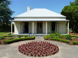
Greenslade House is a distinctive Edwardian house, with a turret,[57] at 1 Wellington Street. It was built between 1910-1912 for a prominent Hamilton businessman and New Zealand Liberal Party MP, Henry Greenslade. The architect, John W Warren, also helped design the Waikato Hospital. The Pearson family (see Oddfellows Hall above) lived in the house from 1934.[57] It remains a private residence, was given Historic Place Category 1 listing on 21 September 1989,[58] is a large 490 with 5 bedrooms and 4 bathrooms[59] and has been sold many times since restoration in the 1970s.[60]
Beale Cottage
The tiny cottage on the corner of Beale and Grey Streets is Hamilton's oldest remaining house, named after the 4th Mayor of Hamilton, Bernard Charles Beale. He designed and built the simple cottage in 1872 using locally-grown kauri and kahikatea. Soon after, he added several more rooms. One room in the house was used as a surgery.
Nga Uri o Hinetuparimaunga
Located at the entrance to Hamilton Gardens, Nga Uri o Hinetuparimaunga is a sculpture created by two internationally renowned artists, sculptor Chris Booth and Diggeress Te Kanawa. Their design proposal was chosen in a competition to which top New Zealand artists had been invited to submit designs. The woven Hinuera stone cloak sculpture honours natural creative processes.[61]
Demographics
| Year | Pop. | ±% p.a. |
|---|---|---|
| 2006 | 10,713 | — |
| 2013 | 11,607 | +1.15% |
| 2018 | 12,996 | +2.29% |
| Source: [62] | ||
Hamilton East, comprising the statistical areas of Hamilton East Village, Greensboro, Hamilton East Cook and Hamilton East, had a population of 12,996 at the 2018 New Zealand census, an increase of 1,389 people (12.0%) since the 2013 census, and an increase of 2,283 people (21.3%) since the 2006 census. There were 4,674 households. There were 6,369 males and 6,630 females, giving a sex ratio of 0.96 males per female, with 2,175 people (16.7%) aged under 15 years, 5,085 (39.1%) aged 15 to 29, 4,728 (36.4%) aged 30 to 64, and 1,014 (7.8%) aged 65 or older.
Ethnicities were 60.6% European/Pākehā, 20.7% Māori, 7.2% Pacific peoples, 20.9% Asian, and 5.0% other ethnicities (totals add to more than 100% since people could identify with multiple ethnicities).
The proportion of people born overseas was 32.9%, compared with 27.1% nationally.
Although some people objected to giving their religion, 45.9% had no religion, 34.1% were Christian, 4.7% were Hindu, 4.0% were Muslim, 1.3% were Buddhist and 4.9% had other religions.
Of those at least 15 years old, 3,117 (28.8%) people had a bachelor or higher degree, and 1,209 (11.2%) people had no formal qualifications. The employment status of those at least 15 was that 4,518 (41.8%) people were employed full-time, 1,914 (17.7%) were part-time, and 843 (7.8%) were unemployed.[62]
| Name | Population | Median age | Median income |
|---|---|---|---|
| Hamilton East Village | 3,204 | 30.8 years | $23,700 |
| Greensboro | 3,795 | 22 years | $13,400 |
| Hamilton East Cook | 2,046 | 27.2 years | $22,500 |
| Hamilton East | 3,951 | 33.3 years | $31,800 |
| New Zealand | 37.4 years | $31,800 |
The 2013 Index of Socioeconomic Deprivation, ranked 1-10 from lowest to most deprived areas, lists the Hamilton East at 9/10 (high deprivation).[63]
Education
Hamilton Boys' High School is a single sex secondary school (years 9-13). It has a roll of 2197.[64] The school opened in 1955, with predecessors dating back to 1903.[65]
Hamilton East School is a coeducational contributing primary school (years 1-6). The school was opened in 1872 and is the oldest school in Hamilton on its original site.[66] It has a roll of 442.[67]
Sacred Heart Girls' College' is a single sex state-integrated Catholic day school (years 9-13). The school was established in 1884[68] and has a roll of 792.[69]
Marian Catholic School is a state-integrated coeducational full primary school (years 1-8). The school was formed in 1989 by the amalgamation of the single-sex St Mary's Cathedral School and Marist School, which had been neighbours on the same site.[70] It has a roll of 609.[71]
All rolls are as of March 2020.[72]
See also
References
- Street Name Index - Hamilton Public Library, Hamilton.
- Westwood, L.G. (1962). Hamilton City - Its Establishment and Development.
- "WWII munitions factory in Hamilton East". DigitalNZ. Retrieved 16 April 2020.
- "Sports Parks Details - Hamilton City Council". www.hamilton.govt.nz. Retrieved 16 April 2020.
- "Earthworks reveal links to Hamilton's wartime past". www.scoop.co.nz. 27 September 2019. Retrieved 16 April 2020.
- "SUBMISSION ON VARIATION 1 RUAKURA" (PDF). Hamilton City Council. December 2015.
- "2013 Census map – QuickStats about a place". archive.stats.govt.nz. Retrieved 14 April 2020.
- "Nottingham Drive". ketehamilton.peoplesnetworknz.info. Retrieved 14 April 2020.
- "Hamilton protesters save trees from axe". NZ Herald. 7 September 2000. ISSN 1170-0777. Retrieved 14 April 2020.
- "Hamilton Gardens". Hamilton City Council. Retrieved 3 September 2010.
- "Hamilton, east of the river". Te Ara Encyclopedia of New Zealand. Retrieved 3 October 2010.
- "Hamilton east of the river". Te Ara Encyclopedia of New Zealand. Retrieved 3 September 2010.
- McEwan, Ann (2008). "The Houses of Hayes Paddock: Hamilton", p.119. Ramp Press, Hamilton, New Zealand. ISBN 978-0-9582902-4-1
- McEwan, Ann (2008). "The Houses of Hayes Paddock: Hamilton", p.15. Ramp Press, Hamilton, New Zealand. ISBN 978-0-9582902-4-1
- "Hamilton, east of the river". Te Ara Encyclopedia of New Zealand. Retrieved 31 March 2011.
- "Variation 11". Hamilton City Council, New Zealand. Retrieved 31 March 2011.
- "Hamilton City Proposed District Plan (References Version 2001)". Hamilton City Council, New Zealand. Retrieved 31 March 2011.
- "Variation No. 11". Hamilton City Council, New Zealand. Retrieved 31 March 2011.
- "Decisions on Submissions to Variation No.11: Hayes Paddock Special Character Area". Hamilton City Council, New Zealand. Retrieved 31 March 2011.
- PJ. de Lange and P.D. Champion (1993). "Vascular flora of Graham Island Waikato River" (PDF).
- "Hayes Paddock/Wellington Street Beach, Hamilton City River Plan". www.hamiltoncityriverplan.co.nz. 2016. Retrieved 19 May 2019.
- "Sporting Facilities, NEW ZEALAND HERALD". paperspast.natlib.govt.nz. 30 November 1945. Retrieved 19 May 2019.
- "We are number one!". Stuff. Retrieved 19 May 2019.
- "Institute de Notre Dames des Missions". Hamilton City Council. Retrieved 3 October 2010.
- "St Mary's Convent Chapel". www.heritage.org.nz. Retrieved 5 April 2020.
- "Hamilton east of the river". Te Ara Encyclopedia of New Zealand. Retrieved 3 October 2010.
- "Improving on Nature? A Critical History of the Hamilton Beautification Society". Australian & New Zealand Environmental History Network. 9 December 2013. Retrieved 27 December 2017.
- Breckon, Arthur Ninnis; Taonga, New Zealand Ministry for Culture and Heritage Te Manatu. "The Rangiriri paddle steamer". teara.govt.nz. Retrieved 27 December 2017.
- "s.s Rangiriri, P.N. Russell & Co. and Hamilton - 150-year Milestones". partofpastnzhistory.blogspot.co.nz. Retrieved 27 December 2017.
- "Chapter 33: The River War Fleet". nzetc.victoria.ac.nz. Retrieved 27 December 2017.
- Cowan, James (1922). The New Zealand wars, a history of the Maori campaigns and the pioneering period. Robarts - University of Toronto. Wellington, Skinner.
- "All hands on deck: gunboat restored". Stuff. Retrieved 27 December 2017.
- "Historic sites - Waikato Museum". waikatomuseum.co.nz. Retrieved 27 December 2017.
- "Hansard Report - Hamilton City Council (Parana Park) Land Vesting Bill". Retrieved 27 December 2017.
- "Thursday Throwback – Waipa Delta in 1985". Stuff.co.nz. 6 September 2012.
- "• View topic – Waipa Delta could be yours". Crew.org.nz. Archived from the original on 23 October 2013.
- "Waikato Regional Council's website has been updated". Waikatoregion.govt.nz. Archived from the original on 21 October 2013.
- "Cruisin' down the Waikato river again". New Zealand Herald. 9 November 2012. ISSN 1170-0777. Retrieved 21 August 2016.
- "Waikato River Explorer Cruises". www.waikatoexplorer.co.nz. Archived from the original on 7 October 2016. Retrieved 21 August 2016.
- "Council Agenda 13 November 2012" (PDF). www.hamilton.govt.nz. Archived from the original (PDF) on 22 August 2016. Retrieved 21 August 2016.
- "90min Café Cruise from The Ferrybank/Museum Jetty & Memorial Park - Waikato River Explorer - Hamilton Cruises Waikato". www.waikatoexplorer.co.nz. Retrieved 27 December 2017.
- "Hamilton City Council (Parana Park) Land Vesting Act 2011 No 1, Local Act – New Zealand Legislation". www.legislation.govt.nz. Retrieved 27 December 2017.
- "Destination Parks - Hamilton City Council". www.hamilton.govt.nz. Retrieved 27 December 2017.
- "PRELIMINARY HERITAGE SCHEDULE MAPS PARANA PARK 2010".
- "Gates open to fish migration at Hamilton's Parana Park". Stuff. Retrieved 27 December 2017.
- "William Steele 1831-1898". Stuff. Retrieved 26 September 2017.
- "Oddfellows' Hall (Former)". www.heritage.org.nz. Retrieved 16 May 2020.
- "Buffalo Hall". Hamilton City Council. Retrieved 3 September 2010.
- "AUCKLAND STAR". paperspast.natlib.govt.nz. 15 November 1884. Retrieved 16 May 2020.
- "The Dead tell tales". www.pressreader.com. 9 April 2012. Retrieved 16 May 2020.
- "TOWN & COUNTRY. NEW ZEALAND MAIL". paperspast.natlib.govt.nz. 10 October 1884. Retrieved 16 May 2020.
- Walsh, G. P., "Pearson, Thomas Edwin (1867–1962)", Australian Dictionary of Biography, National Centre of Biography, Australian National University, retrieved 16 May 2020
- "PEARSON'S PRODUCTS. WAIKATO TIMES". paperspast.natlib.govt.nz. 27 May 1930. Retrieved 16 May 2020.
- "PARK AT WHITIORA. WAIKATO TIMES". paperspast.natlib.govt.nz. 25 October 1934. Retrieved 16 May 2020.
- "70 YEARS REVIEWED. WAIKATO TIMES". paperspast.natlib.govt.nz. 25 August 1934. Retrieved 16 May 2020.
- "St Andrew's Presbyterian Church". Hamilton Libraries Heritage Collection Online. Retrieved 16 May 2020.
- "Greenslade House -Fairytale House By The River". Waikato Museum.
- "Greenslade House". www.heritage.org.nz. Retrieved 5 April 2020.
- "Greenslade House - 1 Wellington Street". Bayleys.co.nz - Real Estate Agency. Retrieved 5 April 2020.
- "Different owners, same home: Hamilton's historic Greenslade House stands for a century". Stuff. Retrieved 5 April 2020.
- "Sculpture at Hamilton Gardens". Hamilton Gardens. Retrieved 3 October 2010.
- "Statistical area 1 dataset for 2018 Census". Statistics New Zealand. March 2020. Hamilton East Village (179700), Greensboro (179900), Hamilton East Cook (180000) and Hamilton East (180200). 2018 Census place summary: Hamilton East Village 2018 Census place summary: Greensboro 2018 Census place summary: Hamilton East Cook 2018 Census place summary: Hamilton East
- "Index of Socioeconomic Deprivation for Areas within the Hamilton East Electorate". Parliament New Zealand. Retrieved 30 October 2020.
- Education Counts: Hamilton Boys' High School
- "The Hamilton Boys' High School History". Hamilton Boys' High School. Retrieved 30 October 2020.
- "Charter 2018" (PDF). Hamilton East School. 2018. p. 2.
- Education Counts: Hamilton East School
- "SHGC History". Sacred Heart Girls' School. Retrieved 30 October 2020.
- Education Counts: Sacred Heart Girls' College
- "Welcome to Marian Catholic School". Marian Catholic School. Retrieved 30 October 2020.
- Education Counts: Marian Catholic School
- "New Zealand Schools Directory". New Zealand Ministry of Education. Retrieved 26 April 2020.