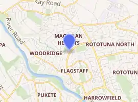
Flagstaff, Hamilton
Flagstaff is a suburb in north-east Hamilton, New Zealand. It was originally called Dulverton on council plans, but it was officially named Flagstaff in 1986 when it was declared as a suburb. The area was heavily developed in the 1990s.[1]
Flagstaff | |
|---|---|
Suburb | |
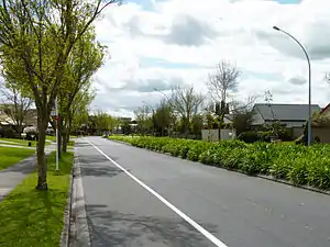 Discovery Drive in Flagstaff, Hamilton | |
| |
| Country | New Zealand |
| Local authority | Hamilton, New Zealand |
| Electoral ward | Hamilton East |
| Established | 1986 |
| Population (2018 Census) | |
| • Total | 9,831 |
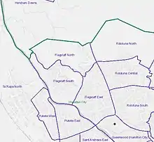
| St Petersburg | Magellan Rise | Gordonton |
| Pukete |
|
Rototuna |
| Te Rapa | Harrowfield | Chartwell |
Sometimes the name Rototuna is used to collectively refer to all of the city north of Wairere Drive and east of the Waikato River, including Flagstaff and its developments of St Petersburg and Magellan Rise.[2]
The name "Flagstaff" comes from the flagstaff that was located on the hillock at the western end of Sylvester Road in the 1870s. A flag was raised by the local farmer when a steamer passed to alert the port authorities in the settlement 7 km further south.
Flagstaff is connected to Pukete by a 5 m wide pedestrian bridge that connects with a series of walkways on both banks of the Waikato River. The suburb is served by a shopping centre with parks for 50 cars. It has 18 shops and a gym.
Two playgrounds serve the new suburbs in northern Flagstaff at Hare Puke Park and Te Huia Reserve.[3]
History
The District Plan lists two middens in the Te Awa O Katapaki valley.[4]
Like most of western Waikato the land at Flagstaff was confiscated following the 1863 invasion of the Waikato. It was surveyed into 50-acre parcels as grants to militiamen of the Fourth Waikato Regiment.[5]
Roads
Until Hamilton's suburbs extended to Flagstaff in the 1990s, the only roads through the area were Rototuna School Rd, River Rd and Sylvester Rd.[6] River Road was shown on an 1865 map of the military settlements[7] and extended form Hamilton to Ngāruawāhia by 1879.[8] A request to improve Flagstaff Hill Rd was made in 1909[9] and it was inspected in 1910.[10] Rototuna School Road was also on the 1865 map and was gravelled[11] in 1909.[12] In 1908 J. and C. Sylvester asked Kirikiriroa Road Board for a road[13] and by 1917 the Board were planning to improve the road.[14]
Geography
Southern Flagstaff is in the Te Awa O Katapaki stream valley, which has a 385 ha (950 acres) catchment. It has short-finned eels, mosquitofish and common smelt.[15] In 2013 fish passage was improved by a new culvert under River Rd.[16] Flows from the urban area are attenuated by Lake Magellan.[17]
The north of Flagstaff is in the 3.2 km (2.0 mi) long southern branch of the Otama-ngenge stream valley. Giant kokopu live the stream. Glaisdale West lakes and wetland were built in 2015 to attenuate flows from the developed area and keep heavy metal run-off from vehicles out of Otama-ngenge stream.[18]
Demographics
| Year | Pop. | ±% p.a. |
|---|---|---|
| 2006 | 3,945 | — |
| 2013 | 5,898 | +5.91% |
| 2018 | 9,831 | +10.76% |
| Source: [19] | ||
Flagstaff, comprising the statistical areas of Flagstaff North, Flagstaff South and Flagstaff East, had a population of 9,831 at the 2018 New Zealand census, an increase of 3,933 people (66.7%) since the 2013 census, and an increase of 5,886 people (149.2%) since the 2006 census. There were 3,234 households. There were 4,695 males and 5,133 females, giving a sex ratio of 0.91 males per female, with 2,373 people (24.1%) aged under 15 years, 1,617 (16.4%) aged 15 to 29, 4,530 (46.1%) aged 30 to 64, and 1,311 (13.3%) aged 65 or older.
Ethnicities were 67.5% European/Pākehā, 9.0% Māori, 1.6% Pacific peoples, 27.3% Asian, and 3.3% other ethnicities (totals add to more than 100% since people could identify with multiple ethnicities).
The proportion of people born overseas was 34.7%, compared with 27.1% nationally.
Although some people objected to giving their religion, 49.8% had no religion, 35.5% were Christian, 3.5% were Hindu, 2.0% were Muslim, 1.1% were Buddhist and 3.4% had other religions.
Of those at least 15 years old, 2,406 (32.3%) people had a bachelor or higher degree, and 912 (12.2%) people had no formal qualifications. The employment status of those at least 15 was that 4,026 (54.0%) people were employed full-time, 1,005 (13.5%) were part-time, and 201 (2.7%) were unemployed.[19]
Individual census areas
Flagstaff now encompasses three census areas, North, East and South. For censuses prior to 2018 it formed a single census area. Growth has mostly been in the northern and southern areas since 2006. In 2018 there were still 63 houses being built (48 North, 3 East, 12 South). In 2018 the main ethnic groups were -
| Area | European | Asian | Māori |
|---|---|---|---|
| North | 59.2% | 35.7% | 8.2% |
| East | 76.4% | 17.6% | 9.3% |
| South | 65.0% | 30.8% | 9.7% |
| North[20] | East[21] | South[22] | National median income | ||||||||||
|---|---|---|---|---|---|---|---|---|---|---|---|---|---|
| Year | Population | Average age | Households | Median income | Population | Average age | Households | Median income | Population | Average age | Households | Median income | |
| 1996 | Until the 2006 census most development was in Flagstaff East and shown only as a Flagstaff area | 1767[23] | |||||||||||
| 2001 | 3399[24] | 36.4 | 1251 | $26,000 | $18,500 | ||||||||
| 2006 | 231 | 3576 | 138 | $24,100 | |||||||||
| 2013 | 786 | 3531 | 1581 | $27,900 | |||||||||
| 2018 | 3192 | 32.4 | 948 | $45,000 | 3810 | 42.7 | 1443 | $33,900 | 2829 | 34.2 | 849 | $47,600 | $31,800 |
Education
Endeavour School and Te Ao Mārama School are coeducational contributing primary schools (years 1–6) with rolls of 457 and 270 students respectively as of March 2020.[25][26][27] Endeavour opened in 2015[28] and Te Ao Mārama opened in 2019.[29]
See also
References
- Flagstaff Information Kit, Hamilton Public Library
- "Rototuna Community Projects" (PDF). Hamilton City Council. 2019.
- "Flagstaff North Destination Playground - Hamilton City Council". www.hamilton.govt.nz. Retrieved 12 March 2020.
- "Operative District Plan" (PDF). Hamilton City Council. 18 October 2017.
- "WDC District Plan Review – Built Heritage Assessment - Historic Overview – Eastern Sector" (PDF). Waikato District Council. 2018.
- "Sheet: N56". www.mapspast.org.nz. 1944. Retrieved 2 May 2020.
- "Plan of the Military settlements in the Upper Waikato District". ap01.alma.exlibrisgroup.com. Retrieved 26 April 2020.
- "KIRIKIRIROA MEETING. WAIKATO TIMES". paperspast.natlib.govt.nz. 12 July 1879. Retrieved 2 May 2020.
- "Kirikiriroa Road Board. WAIKATO ARGUS". paperspast.natlib.govt.nz. 6 March 1909. Retrieved 2 May 2020.
- "Kirikiriroa Road Board. WAIKATO ARGUS". paperspast.natlib.govt.nz. 5 February 1910. Retrieved 2 May 2020.
- "Kirikiriroa Road Board. WAIKATO ARGUS". paperspast.natlib.govt.nz. 3 October 1908. Retrieved 24 April 2020.
- "Rototuna. WAIKATO ARGUS". paperspast.natlib.govt.nz. 28 April 1909. Retrieved 24 April 2020.
- "Kirikiriroa Road Board. WAIKATO ARGUS". paperspast.natlib.govt.nz. 2 May 1908. Retrieved 2 May 2020.
- "KIRIKIRIROA ROAD BOARD - WAIKATO TIMES". paperspast.natlib.govt.nz. 9 January 1917. Retrieved 2 May 2020.
- Dr Brendan J. Hicks, Gavin B. Reynolds, J. Lee Laboyrie, Christopher D. H. Hill (9 October 2001). "Te Awa O Katapaki Stream, Flagstaff, Waikato CBER Contract Report Number 13" (PDF). University of Waikato.CS1 maint: multiple names: authors list (link)
- David, Bruno (2013). "Fish passage" (PDF). Department of Conservation.
- "Proposed Waikato Regional Plan Change 1 - Waikato and Waipa River Catchments Further Submissions by Hamilton City Council" (PDF). Waikato Regional Council. 14 September 2018.
- "Otama-ngenge Integrated Catchment Management Plan" (PDF). Hamilton City Council. September 2015.
- "Statistical area 1 dataset for 2018 Census". Statistics New Zealand. March 2020. Flagstaff North (175300), Flagstaff South (175500) and Flagstaff East (175800). 2018 Census place summary: Flagstaff North 2018 Census place summary: Flagstaff South 2018 Census place summary: Flagstaff East
- "Flagstaff North". Stats NZ. 12 February 2020.
- "Flagstaff East". Stats NZ. 12 February 2020.
- "2018 Census place summaries | Stats NZ". www.stats.govt.nz. Retrieved 12 March 2020.
- "2006 Census of Population and Dwellings - Hamilton City". Stats NZ.
- "2013 Census map – QuickStats about a place". archive.stats.govt.nz. Retrieved 12 March 2020.
- "New Zealand Schools Directory". New Zealand Ministry of Education. Retrieved 26 April 2020.
- Education Counts: Endeavour School
- Education Counts: Te Ao Mārama School
- "Endeavour School - 07/02/2018". Education Review Office. 7 February 2018.
- "Welcome to Te Ao Mārama School". Te Ao Mārama School. Retrieved 14 October 2020.