Durbanville
Durbanville is a town in the Western Cape province of South Africa, part of the greater City of Cape Town metropolitan area.[3] Durbanville is a semi-rural residential suburb on the northern outskirts of the metropolis and is surrounded by farms producing wine and wheat.
Durbanville | |
|---|---|
.jpg.webp) Dutch Reformed Church | |
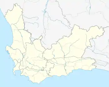 Durbanville  Durbanville | |
| Coordinates: 33°49′57″S 18°38′51″E | |
| Country | South Africa |
| Province | Western Cape |
| Municipality | City of Cape Town |
| Established | 1825[1] |
| Area | |
| • Total | 27.41 km2 (10.58 sq mi) |
| Population (2011)[2] | |
| • Total | 54,286 |
| • Density | 2,000/km2 (5,100/sq mi) |
| Racial makeup (2011) | |
| • Black African | 5.5% |
| • Coloured | 10.1% |
| • Indian/Asian | 1.0% |
| • White | 82.2% |
| • Other | 1.2% |
| First languages (2011) | |
| • Afrikaans | 58.9% |
| • English | 37.2% |
| • Other | 3.8% |
| Time zone | UTC+2 (SAST) |
| Postal code (street) | 7550 |
| PO box | 7551 |
History
Precolonial period (before 1652)
The first modern humans indigenous to the Cape area included the Khoina (informally known as 'Hottentots') and the San ('Bushmen') people. These peoples are believed to have lived in the Cape and its surrounding coastal areas dating as far back as 60 000 years ago.[4] They migrated from the interior of the country, what is today the Northern Cape province, and from Botswana and Namibia to the Cape.[5]
Dutch colonial period (1652-1795)
Durbanville's inception can be traced to a fresh water spring located in the town. The spring is currently situated behind the Durbanville Children's Home.[6] The spring was designated by the VOC (Dutch East India Company, Dutch: Vereenigde Oostindische Compagnie) in the mid-1600's to be used as a water replenishment station for travelers on their way from Cape Town to the interior of southern Africa. In 1661 rhinoceros and ostrich were known to inhabit the area.[7] Durbanville was originally known as Pampoenkraal (from the Afrikaans words pampoen meaning pumpkin, and kraal meaning corral - an enclosure for livestock). This name was attributed to the town because of a pumpkin patch which grew alongside a dam located behind the current Town Hall. Due to the natural spring, Pampoenkraal became a preferred resting place for travelers before continuing on their journey into the interior.[7]
During the late 1600s, the VOC allocated farms to free burghers situated around the town.[7] Some of those farms are still in existence today, many of which are renowned for their wine production. These include Bloemendal, Meerendal, Diemersdal and Altydgedacht.
British colonial period (1795-1902)
The first portions of land were earmarked as residential properties and allocated in 1806, signifying the start and development of Durbanville.[7]
In 1825 a group of local farmers requested permission from Lord Charles Somerset (governor of the Cape Colony at that time) to build their own church. The Dutch Reformed Church was commenced in 1825 and inaugurated a year later on 6 August 1826. A small village grew between the church and the outspan (overnight stop). During 1836 the inhabitants of Pampoenkraal petitioned the Governor of the Cape Colony, Sir Benjamin d'Urban, for permission to rename the village D'Urban in his honour. Permission was duly granted and the new name persisted until 1886 when it was renamed to Durbanville in order to avoid confusion with Durban - a major port city in the east of South Africa.[7]
Durbanville had its own court house, jail and magistrate from the 1870s and became a Magisterial District of Bellville. The court house complex still exists in altered form within the Rust-en-Vrede complex, originally erected in 1850. A village management board was established in 1897 and a municipality in 1901. The first mayor elected was John King.
The village grew rapidly after the turn of the 19th century and a local wagon industry developed. The King Brothers Wagon Works' used to be South Africa's biggest wagon works. At the turn of the century, it employed more than 200 men, which just about accounted for the entire village.
Geography
Durbanville is located around 33°49′57″S 18°38′51″E (-33.83056, 18.65056).
Culture
Afrikaans and English are the main languages spoken in Durbanville. In the past Afrikaans predominated culturally, but this has changed with the rapid development of the town. However the majority (59%) of the town still speaks Afrikaans as a first language. The principal religion of the population is Christianity with a wide variety of churches in the community.
Demographics
According to the 2011 Census, the population of Durbanville was 54,286. The following tables show various demographic data about Durbanville from that census.[2]
- Gender
| Gender | Population | % |
|---|---|---|
| Female | 28 615 | 52.71% |
| Male | 25 671 | 47.29% |
- Racial Makeup
| Group | Population | % |
|---|---|---|
| White | 44 607 | 82.17% |
| Coloured | 5 491 | 10.11% |
| Black African | 2 995 | 5.52% |
| Indian/Asian | 560 | 1.03% |
- Home Language
| Language | Population | % |
|---|---|---|
| Afrikaans | 31 346 | 58.94% |
| English | 19 803 | 37.24% |
| Xhosa | 491 | 0.92% |
| Other African languages | 752 | 1.39% |
| Other languages | 732 | 1.38% |
Education
The town has the following public high schools:
- Durbanville High School (an Afrikaans-medium school)
- Fairmont High School (an English-medium school)
- Stellenberg High School (an Afrikaans and English-medium school)
There are numerous primary schools, including:
The area also has a number of private schools:
Suburban Areas
- Amanda Glen (Residential)
- Aurora (Residential)
- Avalon Estate (Residential)
- Bergsig (Residential)
- Brentwood Park (Residential)
- Country Places (Residential)
- D'urbanvale (Residential)
- Durbanville Hills (Residential)
- Durbell (Residential)
- Durmonte (Residential)
- Everglen (Residential)
- Eversdal (Residential)
- Eversdal Heights (Residential)
- Goedemoed (Residential)
- Graanendal (Residential)
- Halali (Residential)
- Kenridge (Residential)
- Kenridge Heights (Residential)
- Klein Nederburg (Residential)
- Langeberg Village (Residential)
- Morningstar (Residential)
- Pinehurst (Residential)
- Proteaville (Residential)
- Rosedale (Residential)
- Schoongezicht (Residential)
- Sonstraal (Residential)
- Sonstraal Heights (Residential)
- Tara (Residential)
- The Crest (Residential)
- Uitzicht (Residential)
- Valmary Park (Residential)
- Vergesig (Residential)
- Vierlanden (Residential)
- Vygeboom (Residential)
- Welgevonden Estate (Residential)
- Wellway Park (Residential)
- Wellway Park East (Residential)
Airfield
Fisantekraal Airfield is located approximately 13 km NE of Durbanville. It is an ex-airforce airfield built circa 1943, where the airforce used to operate Ventura bombers from. It is now in private ownership since 1993. It serves as a general flying airfield, and is a favourite for flight training. Operators at the airfield are Cape Town Flight Training Center and Aerosport Training. The Fighting on Fire organisation also has a summer base at Fisantekraal. The ICAO designator is FAFK and radio frequency is 131.1 MHz, Coord S33 46';E018 44'. Elevation: 400 ft. Runway: 05/23 and 14/32. Avgas fuel is available.
Nature Reserves
There are two nature reserves in Durbanville which are the Durbanville and Uitkamp Wetland Nature Reserve. Durbanville Nature Reserve is adjacent to the racecourse and along Race Course Road (M13). Uitkamp Wetland Nature Reserve is located in D'Urbanvale, a northern suburb of Durbanville.
Famous residents
- Mark Shuttleworth, founder of Thawte and second self-funded space tourist.
- Amore Bekker, radio personality, author, MC and columnist.
- Jody Williams, winner of Idols season 4
- Daniele Pascal, French Chanteuse, Actor and Playwright, and owner of Villa Pascal Guest House (B+B) and Theatre
- Annelisa Weiland, actress. Played Hilda de Kock on popular South African soapie 7de Laan for almost 20 years.
- Duane Vermeulen, rugby union player for Western Province, Stormers and the Springboks.
- Jack Parow, Afrikaans rapper.
- Zanne Stapelberg, international operatic soprano.
Coat of arms
The Durbanville municipal council assumed a coat of arms, designed by Ivan Mitford-Barberton and H. Ellis Tomlinson, in April 1948,[8] and registered them at the Bureau of Heraldry in February 1981.The National Archives and Records Service of South Africa (NARSSA)
The arms, derived from those of Sir Benjamin d'Urban, were : Or, on a chevron between in chief two six-pointed stars Sable and in base a bunch of grapes proper, three garbs Or. In layman's term, the shield is gold and depicts, from top to bottom, two black six-pointed stars, a blue chevron bearing three golden sheaves of wheat, and a bunch of grapes.
The crest was a red sphinx charged with three golden rings, and the motto Sit nomine digna.
References
- "Chronological order of town establishment in South Africa based on Floyd (1960:20-26)" (PDF). pp. xlv–lii. Archived from the original (PDF) on 2013-09-15. Retrieved 2012-03-21.
- "Main Place Durbanville". Census 2011.
- "City of Cape Town Metropolitan Municipality (CPT)". Municipalities of South Africa. 6 September 2020. Retrieved 6 September 2020.
- Walters, Nicolaas (2015). From Pampoenkraal to Durbanville - A Taverner's trip through the history of the Tygerberg and its environs. Cape Town: Mega Digital. p. 1. ISBN 978-0-620-67069-2.
- Schuster, Stephen; Miller, Webb; Hayes, Vanessa (18 February 2010). "Complete Khoisan and Bantu genomes from southern Africa". Nature. 463. doi:10.1038/nature08795.
- Erasmus, Esme (15 November 2017). "Pampoenkraal spring a well of history". Netwerk24. Retrieved 6 September 2020.
- Walters, Nicolaas (2015). From Pampoenkraal to Durbanville - A Taverner's trip through the history of the Tygerberg and its environs. Cape Town: Mega Digital. p. 2. ISBN 978-0-620-67069-2.
- Western Cape Archives : Durbanville Municipal Minutes (12 April 1948).
| Wikimedia Commons has media related to Durbanville. |
Communities of City of Cape Town Metropolitan Municipality, Western Cape | ||
|---|---|---|
Seat: Cape Town | ||
| Atlantic Seaboard | .svg.png.webp) City of Cape Town within South Africa | |
| Blaauwberg | ||
| Cape Flats |
| |
| City Centre | ||
| Helderberg | ||
| Northern Suburbs | ||
| Southern Suburbs | ||
| South Peninsula | ||