Foreshore, Cape Town
The Foreshore is an area in Cape Town, South Africa, situated between the historic city centre and the modern Port of Cape Town. It is built on land reclaimed from Table Bay in the 1930s and 1940s in connection with the construction of the Duncan Dock to replace the old harbour. Much of the Foreshore area is occupied by transport infrastructure for the port and Cape Town Railway Station. Other notable buildings in the area are the Cape Town Civic Centre, the Artscape Theatre Centre, and the Cape Town International Convention Centre. When the area was reclaimed, the Government undertook a detailed study (the Szlumper Commission) to decide how to use the land not needed by South African Railways. This resulted in the issuance of a detailed proposal, The Cape Town Foreshore Plan.[2]
Foreshore | |
|---|---|
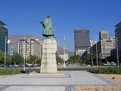 Statue of Bartolomeu Dias on the Heerengracht in the Foreshore | |
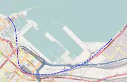 Map showing the Foreshore and the approximate location of the original coastline | |
 Foreshore Map showing the Foreshore and the approximate location of the original coastline  Foreshore Foreshore (South Africa) | |
| Coordinates: 33.92°S 18.43°E | |
| Country | South Africa |
| Province | Western Cape |
| Municipality | City of Cape Town |
| Main Place | Cape Town |
| Area | |
| • Total | 2.34 km2 (0.90 sq mi) |
| Population (2011)[1] | |
| • Total | 268 |
| • Density | 110/km2 (300/sq mi) |
| Racial makeup (2011) | |
| • Black African | 43.3% |
| • Coloured | 11.2% |
| • Indian/Asian | 6.3% |
| • White | 34.0% |
| • Other | 5.2% |
| First languages (2011) | |
| • English | 78.3% |
| • Afrikaans | 14.5% |
| • Other | 7.2% |
| Time zone | UTC+2 (SAST) |
| Postal code (street) | 8001 |
External links
| Wikimedia Commons has media related to Foreshore, Cape Town. |
References
- "Sub Place Foreshore". Census 2011.
- See "The Cape Town Foreshore Plan: Final Report of the Cape Town Foreshore Technical Committee, 1947" (1948, Government Printer of the Union of South Africa).