Noordhoek, Cape Town
Noordhoek is a seaside town in the Western Cape, South Africa, located below Chapman's Peak on the west coast of the Cape Peninsula and is approximately 35 kilometres (22 mi) to the south of Cape Town. The name "Noordhoek" was taken from Dutch and literally means "north corner". It is best known for its shoreline and its long, wide, sandy beach, which stretches south to the neighbouring village of Kommetjie. Near the southern end of this beach is the wreck of the steamship "Kakapo", which ran aground in 1900, when the captain mistook Chapmans' Peak for the Cape of Good Hope and put the helm over to port.[2]
Noordhoek | |
|---|---|
 Noordhoek Beach from Chapman's Peak Drive with Kommetjie in the distance. | |
 Noordhoek  Noordhoek | |
| Coordinates: 34.104°S 18.360°E | |
| Country | South Africa |
| Province | Western Cape |
| Municipality | City of Cape Town |
| Area | |
| • Total | 29.05 km2 (11.22 sq mi) |
| Population (2011)[1] | |
| • Total | 31,980 |
| • Density | 1,100/km2 (2,900/sq mi) |
| Racial makeup (2011) | |
| • Black African | 67.3% |
| • Coloured | 2.3% |
| • Indian/Asian | 0.4% |
| • White | 24.6% |
| • Other | 5.4% |
| First languages (2011) | |
| • Xhosa | 47.4% |
| • English | 28.5% |
| • Afrikaans | 4.8% |
| • Sotho | 1.1% |
| • Other | 18.2% |
| Time zone | UTC+2 (SAST) |
| PO box | 7979 |
Noordhoek can be accessed either from the scenic coastal road, Chapman's Peak Drive, which leads out of Hout Bay or via the mountain road Ou Kaapse Weg which cuts through the Silvermine Nature Reserve - now part of the Table Mountain National Park. Noordhoek is a small scattered community of houses, often with sea views and has a large horse population as riding on the long sandy beach is common. Many artists live in Noordhoek.
Gallery
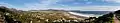 Overview of Noordhoek.
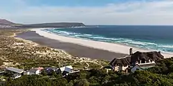
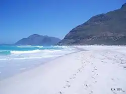 Looking north along the beach. The slopes of Chapman's Peak rise to the right at the end of the sand. The peak in the distance is Karbonkelberg, west of Hout Bay
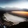 An evening flight over Noordhoek Beach, with Kommetjie in the distance.
References
- "Main Place Noordhoek". Census 2011.
- Turner, M (1988). Shipwrecks & Salvage is South Africa. Cape Town: Struik. ISBN 0-86977-387-9.
External links
| Wikimedia Commons has media related to Noordhoek. |
 Noordhoek travel guide from Wikivoyage