Fresnaye, Cape Town
Fresnaye is one of Cape Town's most affluent suburbs, situated between Signal Hill and Sea Point, a few kilometres to the west of Cape Town's Central Business District (CBD).
Fresnaye | |
|---|---|
Suburb of Cape Town | |
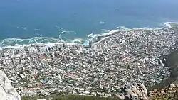 Fresnaye and Sea Point as seen from Lion's Head which surrounds the suburb on the East. Sea Point is to the North and the West separating the suburb from the Atlantic Ocean. | |
 Fresnaye  Fresnaye | |
| Coordinates: 33°55′30″S 18°23′15″E | |
| Country | South Africa |
| Province | Western Cape |
| Municipality | City of Cape Town |
| Main Place | Cape Town |
| Government | |
| • Type | Metropolitan Council Ward 54 |
| • Councillor | Beverley Schäfer [1] (DA) |
| Area | |
| • Total | 0.73 km2 (0.28 sq mi) |
| Population (2011)[2] | |
| • Total | 2,011 |
| • Density | 2,800/km2 (7,100/sq mi) |
| Racial makeup (2011) | |
| • Black African | 9.5% |
| • Coloured | 4.0% |
| • Indian/Asian | 0.8% |
| • White | 83.1% |
| • Other | 2.6% |
| First languages (2011) | |
| • English | 81.2% |
| • Afrikaans | 9.8% |
| • Xhosa | 1.8% |
| • Other | 7.3% |
| Time zone | UTC+2 (SAST) |
| Postal code (street) | 8005 |
| Area code | 021 |
History
Fresnaye was originally an Estate of 200 acres, acquired in the early 1800s, and belonging to Ryk Le Sueur, a barrister, and French aristocrat from Bayeux in Normandy and descendant of the French Huguenots. The original name was Winterslust, and the farmhouse was at that time, the only building on the mountain slopes, other than Heeren Huis near Bantry Bay, built in 1776. Fresnaye was set in vineyards and orchards, and referred to as "A Garden of Eden" at the time.
The suburbs street names reflect its French heritage to this day.
Geography
Fresnaye is set on the slopes of Lion’s Head on the East and between Sea Point and Bantry Bay to the suburb's North West and South West respectively.
References
- "Councillor Details: Beverley Schäfer". City of Cape Town. Retrieved March 24, 2013.
- "Sub Place Fresnaye". Census 2011.