Eisenstadt
Eisenstadt (German pronunciation: [ˈaɪ̯zn̩ʃtat]; Hungarian: Kismarton; Croatian: Željezni grad; Željezno; Slovene: Železno) is a city in Austria, the state capital of Burgenland. It had a recorded population on 1 January 2020 of 14,815.
Eisenstadt | |
|---|---|
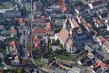
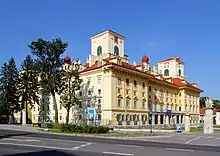
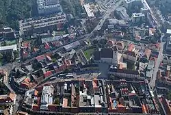 Aerial view of Eisenstadt | |
 Coat of arms | |
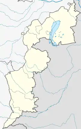 Eisenstadt Location within Burgenland  Eisenstadt Location within Austria | |
| Coordinates: 47°51′N 16°31′E | |
| Country | |
| State | Burgenland |
| District | Statutory city |
| Government | |
| • Mayor | Thomas Steiner (politician) (ÖVP) |
| Area | |
| • Total | 42.88 km2 (16.56 sq mi) |
| Elevation | 182 m (597 ft) |
| Population (2018-01-01)[2] | |
| • Total | 14,476 |
| • Density | 340/km2 (870/sq mi) |
| Time zone | UTC+1 (CET) |
| • Summer (DST) | UTC+2 (CEST) |
| Postal code | 7000 |
| Area code | 02682 |
| Vehicle registration | E |
| Website | www.eisenstadt.at |
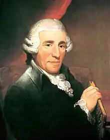
In the Habsburg Empire's Kingdom of Hungary, Kismarton (Eisenstadt) was the seat of the Eszterházy Hungarian noble family. The composer Joseph Haydn lived there as Hofkapellmeister under Esterházy patronage.
Geography
Eisenstadt lies on a plain leading down to the river Wulka, at the south foot of the Leitha Mountains, about 12 kilometres (7 miles) from the Hungarian border.
Subdivisions
Eisenstadt is divided into three districts (Stadtbezirke):
- Eisenstadt-Stadt
- Kleinhöflein im Burgenland (Hungarian: Kishöflány; Croatian: Mala Holovajna) – a town that lies to the west of Eisenstadt proper
- St. Georgen am Leithagebirge (Lajtaszentgyörgy; Svetojurje) – a town that lies to the east of Eisenstadt proper
The city is divided into five Katastralgemeinden:
- Eisenstadt-Stadt
- Oberberg, or Oberberg-Eisenstadt (Hungarian: Felsőkismartonhegy; Croatian: Željezno Brig) – the northern area of Eisenstadt from the Jewish quarter, Jewish cemetery
- Unterberg, or Unterberg-Eisenstadt (Alsókismartonhegy; Željezno Donji Brig) – the southern area of Eisenstadt from Kalvarienbergplatz, Ruster Strasse
- Kleinhöflein im Burgenland
- St. Georgen am Leithagebirge
Other informal areas of the city include Wiesäcker and Lobäcker, which lie south of the Eisbach, a tributary of the Wulka. The city is surrounded by the district (Bezirk) of Eisenstadt-Umgebung.
The city previously included the districts (Ortsteile) of Eisenstadt-Stadt, Eisenstadt-Oberberg, Eisenstadt-Unterberg, and Eisenstadt-Schloßgrund (Kismartonváralja).
Nearby municipalities
- Großhöflein, Müllendorf, Steinbrunn, Neufeld/Leitha and Ebenfurth
- Hornstein
- Wulkaprodersdorf, Trausdorf/Wulka (on the Wulka and Eisbach)
Climate
| Climate data for Eisenstadt (1981–2010) | |||||||||||||
|---|---|---|---|---|---|---|---|---|---|---|---|---|---|
| Month | Jan | Feb | Mar | Apr | May | Jun | Jul | Aug | Sep | Oct | Nov | Dec | Year |
| Record high °C (°F) | 20.5 (68.9) |
21.1 (70.0) |
24.1 (75.4) |
27.2 (81.0) |
33.2 (91.8) |
36.1 (97.0) |
38.7 (101.7) |
38.4 (101.1) |
33.7 (92.7) |
28.0 (82.4) |
21.9 (71.4) |
19.8 (67.6) |
38.7 (101.7) |
| Average high °C (°F) | 3.1 (37.6) |
5.3 (41.5) |
10.4 (50.7) |
16.1 (61.0) |
21.1 (70.0) |
24.0 (75.2) |
26.7 (80.1) |
26.1 (79.0) |
20.9 (69.6) |
15.0 (59.0) |
8.3 (46.9) |
3.5 (38.3) |
15.0 (59.0) |
| Daily mean °C (°F) | −0.1 (31.8) |
1.3 (34.3) |
5.5 (41.9) |
10.7 (51.3) |
15.7 (60.3) |
18.8 (65.8) |
21.0 (69.8) |
20.2 (68.4) |
15.5 (59.9) |
10.2 (50.4) |
4.9 (40.8) |
0.8 (33.4) |
10.4 (50.7) |
| Average low °C (°F) | −2.8 (27.0) |
−1.7 (28.9) |
1.8 (35.2) |
6.0 (42.8) |
10.5 (50.9) |
13.7 (56.7) |
15.7 (60.3) |
15.5 (59.9) |
11.5 (52.7) |
6.9 (44.4) |
2.3 (36.1) |
−1.6 (29.1) |
6.5 (43.7) |
| Record low °C (°F) | −21.6 (−6.9) |
−19.8 (−3.6) |
−19.2 (−2.6) |
−2.8 (27.0) |
1.2 (34.2) |
3.7 (38.7) |
6.9 (44.4) |
6.8 (44.2) |
2.1 (35.8) |
−5.9 (21.4) |
−12.3 (9.9) |
−17.8 (0.0) |
−21.6 (−6.9) |
| Average precipitation mm (inches) | 38 (1.5) |
34 (1.3) |
59 (2.3) |
52 (2.0) |
77 (3.0) |
90 (3.5) |
77 (3.0) |
91 (3.6) |
78 (3.1) |
53 (2.1) |
57 (2.2) |
51 (2.0) |
758 (29.8) |
| Average snowfall cm (inches) | 13 (5.1) |
10 (3.9) |
6 (2.4) |
0 (0) |
0 (0) |
0 (0) |
0 (0) |
0 (0) |
0 (0) |
0 (0) |
5 (2.0) |
12 (4.7) |
46 (18) |
| Average relative humidity (%) (at 14:00) | 70.5 | 62.6 | 56.5 | 50.4 | 52.9 | 53.5 | 50.2 | 51.4 | 56.0 | 62.3 | 70.6 | 74.7 | 59.3 |
| Mean monthly sunshine hours | 73 | 107 | 145 | 204 | 246 | 245 | 272 | 254 | 188 | 139 | 72 | 53 | 1,999 |
| Percent possible sunshine | 27.7 | 38.3 | 41.0 | 51.8 | 55.2 | 54.4 | 59.7 | 60.1 | 51.8 | 42.7 | 26.6 | 21.1 | 44.2 |
| Source: Central Institute for Meteorology and Geodynamics[3][4][5][6][7] | |||||||||||||
| Climate data for Eisenstadt (1971–2000) | |||||||||||||
|---|---|---|---|---|---|---|---|---|---|---|---|---|---|
| Month | Jan | Feb | Mar | Apr | May | Jun | Jul | Aug | Sep | Oct | Nov | Dec | Year |
| Record high °C (°F) | 18.8 (65.8) |
19.7 (67.5) |
27.4 (81.3) |
27.2 (81.0) |
30.8 (87.4) |
36.1 (97.0) |
36.4 (97.5) |
37.0 (98.6) |
33.7 (92.7) |
26.4 (79.5) |
21.9 (71.4) |
19.8 (67.6) |
37.0 (98.6) |
| Average high °C (°F) | 2.8 (37.0) |
5.3 (41.5) |
10.4 (50.7) |
15.3 (59.5) |
20.6 (69.1) |
23.4 (74.1) |
25.9 (78.6) |
25.7 (78.3) |
20.9 (69.6) |
14.8 (58.6) |
7.7 (45.9) |
4.0 (39.2) |
14.7 (58.5) |
| Daily mean °C (°F) | −0.4 (31.3) |
1.3 (34.3) |
5.5 (41.9) |
9.9 (49.8) |
15.1 (59.2) |
18.1 (64.6) |
20.2 (68.4) |
19.8 (67.6) |
15.3 (59.5) |
9.8 (49.6) |
4.3 (39.7) |
1.1 (34.0) |
10.0 (50.0) |
| Average low °C (°F) | −2.9 (26.8) |
−1.6 (29.1) |
1.9 (35.4) |
5.5 (41.9) |
10.1 (50.2) |
13.2 (55.8) |
15.2 (59.4) |
15.1 (59.2) |
11.4 (52.5) |
6.5 (43.7) |
1.7 (35.1) |
−1.2 (29.8) |
6.2 (43.2) |
| Record low °C (°F) | −21.6 (−6.9) |
−19.8 (−3.6) |
−19.2 (−2.6) |
−4.0 (24.8) |
−1.6 (29.1) |
3.7 (38.7) |
6.2 (43.2) |
3.8 (38.8) |
2.1 (35.8) |
−5.3 (22.5) |
−12.3 (9.9) |
−17.8 (0.0) |
−21.6 (−6.9) |
| Average precipitation mm (inches) | 33.7 (1.33) |
29.7 (1.17) |
45.1 (1.78) |
51.9 (2.04) |
62.6 (2.46) |
71.2 (2.80) |
66.7 (2.63) |
59.8 (2.35) |
58.8 (2.31) |
43.7 (1.72) |
53.6 (2.11) |
41.2 (1.62) |
618.0 (24.33) |
| Average snowfall cm (inches) | 12.0 (4.7) |
8.8 (3.5) |
6.4 (2.5) |
0.8 (0.3) |
0.0 (0.0) |
0.0 (0.0) |
0.0 (0.0) |
0.0 (0.0) |
0.0 (0.0) |
0.0 (0.0) |
5.0 (2.0) |
14.1 (5.6) |
47.1 (18.5) |
| Average precipitation days (≥ 1.0 mm) | 6.1 | 5.9 | 8.1 | 7.7 | 8.5 | 9.3 | 8.5 | 8.2 | 7.0 | 5.9 | 7.8 | 6.9 | 89.9 |
| Average relative humidity (%) (at 14:00) | 72.8 | 65.1 | 57.0 | 51.7 | 52.8 | 53.4 | 50.7 | 51.1 | 56.2 | 61.8 | 71.2 | 74.5 | 59.9 |
| Mean monthly sunshine hours | 68.9 | 105.8 | 136.1 | 188.0 | 237.1 | 232.5 | 252.3 | 244.0 | 176.2 | 136.3 | 70.4 | 50.1 | 1,897.7 |
| Percent possible sunshine | 26.2 | 37.9 | 38.6 | 47.7 | 53.5 | 52.1 | 55.8 | 57.8 | 48.4 | 41.8 | 25.9 | 20.3 | 42.2 |
| Source: Central Institute for Meteorology and Geodynamics[8] | |||||||||||||
Names and etymology
The city's name means "Iron City" and was first recorded in 1118 as Castrum ferrum, referring to the history of iron mining and iron trade in the area. The first written mention of the town is from 1264 as "minor Mortin", matching the Hungarian name, Kismarton, which recalls Martin of Tours, the patron saint of the main church.
History
Archeological finds prove that the Eisenstadt area was already settled in the Hallstatt period. Celts and Romans settled somewhat later. During the Migration Period, the area was settled by different Germanic tribes and the Huns. Around 800, during the reign of Charlemagne, settlement by the Bavarii began. The territory became part of the Kingdom of Hungary in the 11th century.
The fortress built on the original earth works was destroyed by the troops of Margrave Leopold III of Austria. In 1241, it was destroyed by the Mongol invaders. In 1373, the town came into the possession of the Kanizsai family, who rebuilt the walls surrounding the town and built a fortress at the site of the present day castle between 1388 and 1392. In 1388, Eisenstadt was given the right to hold markets by Emperor Sigismund.
From 1440 Archduke Albert VI of Austria held the town as collateral for a loan. In 1451, Matthias Corvinus ceded it to Frederick III, Holy Roman Emperor in return for the Holy Crown of Hungary. Matthias Corvinus reconquered it by force in 1482, but Maximilian I acquired it again in 1490. It remained under Habsburg rule until 1622; however, the Ottoman Empire briefly conquered Kismarton in 1529 and 1532 during their advances on the city of Vienna (see Ottoman wars in Europe). It was destroyed by fire in 1589.
In 1648, it passed under the rule of the Esterházy family. These Hungarian princes permanently changed the face of the city due to their extensive construction, especially on their castle, Schloss Esterházy. During this period, the city was captured by the army of Imre Thököly in 1683, and it saw the defeat of the rebel kuruc army of Sándor Károlyi by the Habsburgs in 1704. It was again destroyed by fire in 1776.
The appointment of Joseph Haydn as the prince's Hofkapellmeister (court orchestra director, composing and performing music) began the great artistic period in the city's history. In 1809, Eisenstadt was occupied by French troops during the Napoleonic Wars; in 1897, it was joined to the railway network.
Until the end of World War I, it was the seat of Kismarton district in Sopron county in the Kingdom of Hungary. Without plebiscite, the city and the entire Hungarian territory of Burgenland (with the exception of the city of Sopron and 11 other villages where referendums were held) was annexed to Austria by the Saint-Germain and Treaties of Trianon in 1921. Since 30 April 1925, Eisenstadt has been the seat of the Burgenland state government and thus the state capital. During World War II, Eisenstadt was heavily bombarded. On 2 April 1945, it was captured by Soviet troops of the 3rd Ukrainian Front in the course of the Vienna Offensive, and the city remained under Soviet occupation until 1955. In 1960, Eisenstadt became the see of its own Roman Catholic diocese.
Politics
The current mayor of Eisenstadt is Mag. Thomas Steiner ÖVP.
The district council is composed as follows (as of 2007):
- Austrian People's Party (ÖVP): 17 seats
- Social Democratic Party of Austria (SPÖ): 8 seats
- Austrian Green Party (Die Grünen): 2 seats
- Freedom Party of Austria (FPÖ): 2 seats
Main sights
Castles and palaces
- Schloss Esterházy and Schlosspark, the Esterházy castle and park.
- Gloriette, the former Esterházy hunting lodge.
Religious edifices
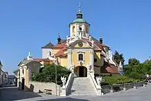
- Bergkirche, housing Haydn's tomb
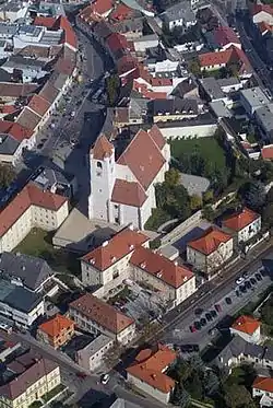
- Eisenstadt Cathedral, late Gothic former military church, began in 1460
- Franziskanerkirche (Franciscan church), built in 1629, it contains the crypt of the Esterházy family
- Jewish quarter[9]
- Jewish Community of Eisenstadt (1732–1938, 1945–)
- A private synagogue Österreichisches Jüdisches Museum, formerly Samson Wertheimer's house
- Jewish cemetery of Eisenstadt
Buildings
- Haydn-Mausoleum
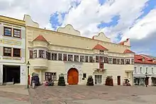
- Rathaus (City Hall)
- Pulverturm (lit. "Powder tower")
Museums
- Haydnmuseum, a museum dedicated to Joseph Haydn, who lived in the building between 1766 and 1778.
- Landesmuseum (regional museum).
- Österreichisches Jüdisches Museum (Austrian Jewish Museum).
- Diözesanmuseum (museum of the local Roman Catholic diocese).
- Feuerwehrmuseum (fire department museum).
Gallery
Culture
Eisenstadt hosts a Haydn festival, the Haydnfestspiele.
Twin towns — sister cities
Eisenstadt is twinned with:
Notable People
Natives
- Moritz Benedikt (1835–1920) neurologist
- Isaiah Berlin (1725–1799) rabbi
- Stefan Billes (1909, Kleinhöflein – 2002) politician
- Friedrich Bridgetower (1782-1813) composer, cellist, brother of George Bridgetower
- Akiva Eiger (1761–1837) rabbi and champion of Orthodox Judaism
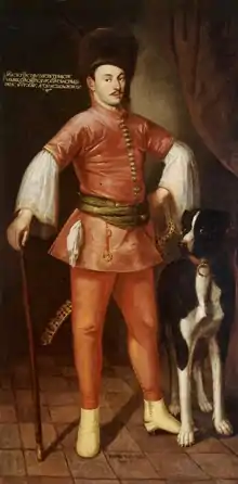
- Paul I, 1st Prince Esterházy of Galántha (1635–1713)
- Prince Paul II Anton Esterházy (1711–1762) soldier and patron of music
- Gyula Farkas (1894–1958) linguist
- Andrea Fraunschiel (1955–2019) mayor
- Josef Hyrtl (1810–1894) anatomist
- Andreas Ivanschitz (1983 – ) football player, lived in Baumgarten, about 12 km (7 mi) from Eisenstadt
- Josef Kirchknopf (1930, Kleinhöflein – ), politician
- Johann Luif (1959, Kleinhöflein – ), BG, Commander Provincial Military Headquarters Burgenland
- Maria Perschy (1938–2004, Vienna) actress
- Rudolf Simek (1954– ) Germanist and Philologian.
- Martin Vukovich (1944 – ) diplomat
- Joseph Franz Weigl (1740–1820) cellist
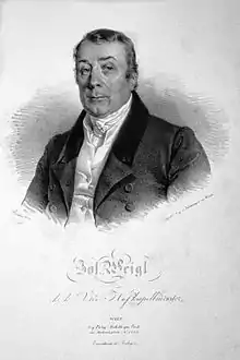
- Joseph Weigl (1766–1846) composer and conductor
- Anton Pauschenwein (1981 – ) football player
- Thomas Mandl (1979 – ) football player
- Michael Mörz (1980 – ) football player
- Johann Dihanich (1958 – ) football player
Other residents
- Samuel Löw Brill (1814–1897), rabbi and Talmudical scholar; born in Budapest; attended yeshiva
- Meir Eisenstadt (1670–1744) rabbi of the Siebengemeinden
- Joseph Haydn (1732–1809), musician, born in Rohrau
- Azriel Hildesheimer (1820–1899), German rabbi, founder of Torah im Derech Eretz; in 1851, he was called to the rabbinate of Eisenstadt
- Markus Horovitz (1844–1915), German rabbi and historian; born March 14, 1844, in Tiszaladány, Hungary, pursued his rabbinical studies at the yeshiva
- Johann Nepomuk Hummel (1778–1837), musician
- Paul Iby (born 1935), a reformist Roman Catholic bishop
- Adam Liszt (1776–1827), musician, father of Franz Liszt
- Leopold Löw (1811–1875), born in Černá Hora, Moravia, studied at the yeshiva of Eisenstadt
- Mordecai Mokiach (ca. 1650–1724), "pseudo"-Messiah, born in Alsace
- Robert Musil (1880–1942), author
- Ignaz Pleyel (1757–1831), composer
- Emanuel Schreiber (1852–1932), rabbi
- Fritz Spiegl (1926–2003) musician, journalist, broadcaster, humorist and collector
- Isaac Hirsch Weiss (1815–1905), talmudist and historian of literature; born at Velké Meziříčí, Moravia; studied at yeshiva
- Samson Wertheimer (1658–1724), rabbi
- Aaron Wise (1844–1896), rabbi, born in Eger, Hungary, studied at yeshiva; the father of Stephen Samuel Wise
As a surname
Eisenstadt (also Ajzenstat, Eisenstaedter, Asch, etc.), a Jewish surname, derives from this city.[10] Some people with this surname or its variants include:
- Alfred Eisenstaedt
- Meir Eisenstadt
- Shmuel Eisenstadt Israeli sociologist
- Stuart E. Eizenstat
- Moses Asch
References
- "Dauersiedlungsraum der Gemeinden Politischen Bezirke und Bundesländer - Gebietsstand 1.1.2018". Statistics Austria. Retrieved 10 March 2019.
- "Einwohnerzahl 1.1.2018 nach Gemeinden mit Status, Gebietsstand 1.1.2018". Statistics Austria. Retrieved 9 March 2019.
- "Klimamittel 1981–2010: Lufttemperatur" (in German). Central Institute for Meteorology and Geodynamics. Archived from the original on 21 October 2019. Retrieved 29 October 2019.
- "Klimamittel 1981–2010: Niederschlag" (in German). Central Institute for Meteorology and Geodynamics. Archived from the original on 29 December 2014. Retrieved 29 October 2019.
- "Klimamittel 1981–2010: Schnee" (in German). Central Institute for Meteorology and Geodynamics. Archived from the original on 29 December 2014. Retrieved 29 October 2019.
- "Klimamittel 1981–2010: Luftfeuchtigkeit" (in German). Central Institute for Meteorology and Geodynamics. Archived from the original on 21 October 2019. Retrieved 29 October 2019.
- "Klimamittel 1981–2010: Strahlung" (in German). Central Institute for Meteorology and Geodynamics. Archived from the original on 29 December 2014. Retrieved 29 October 2019.
- "Klimadaten von Österreich 1971–2000 – Burgenland-Eisenstadt" (in German). Central Institute for Meteorology and Geodynamics. Archived from the original on 12 October 2019. Retrieved 29 October 2019.
- Filckr photos: ,
- Asch and its variants are an abbreviation for Eisenstadt. see "Ash". Jewish Encyclopedia. 1906.
External links
| Wikivoyage has a travel guide for Eisenstadt. |
| Wikimedia Commons has media related to Eisenstadt. |
- Official site (in German)
- Official Eisenstadt Tourism Site
- Eisenstadt on the official Burgenland site (in German)
- Österreichisches Jüdisches Museum (Austrian Jewish Museum) (in German)
- Jewish Encyclopedia article on the Jewish community of Eisenstadt (in English)
- Schloss Esterházy (Esterházy Castle) (in German)
- Haydn festival (in German and English)
- Fachhochschul-Studiengänge Burgenland University of applied sciences. (in German)
- "Iron City", Eisenstadt page for young adult activities. (in German)
- Eisenstadt in English (in English)
| Cities | 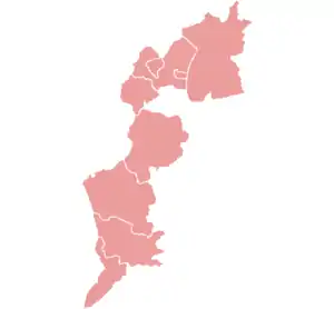 | |
|---|---|---|
| Districts | ||
| Authority control |
|---|
