Saint Helier
St. Helier (/ˈhɛliər/; Jèrriais: Saint Hélyi; French: Saint-Hélier) is one of the twelve parishes of Jersey, the largest of the Channel Islands in the English Channel. St Helier has a population of about 33,500, roughly 34.2% of the total population of Jersey, and is the capital of the island (although Government House is situated in St Saviour).
Saint Helier
| |
|---|---|
         Saint Helier | |
 Flag .svg.png.webp) Coat of arms | |
| Nickname(s): Town | |
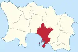 Location of Saint Helier in Jersey | |
 Saint Helier Location of Saint Helier in Jersey | |
| Coordinates: 49.187°N 2.107°W | |
| Sovereign state | United Kingdom |
| Crown Dependency | Jersey |
| Named for | Helier, patron saint of Jersey |
| Vigntaines | List
|
| Government | |
| • Connétable | Simon Crowcroft (Ind.) |
| Area | |
| • Total | 4.1 sq mi (10.6 km2) |
| Area rank | Ranked 5th |
| Population (2011) | |
| • Total | 33,500 |
| • Density | 8,200/sq mi (3,200/km2) |
| Time zone | GMT |
| • Summer (DST) | UTC+01 |
| Postcode district | |
| Postcode sector | 3 and 4 |
| Website | www.sthelier.je |
The Town of St. Helier (commonly referred to by locals as just "town") is the largest settlement and only town of Jersey. The town consists of the built-up areas of St Helier, including First Tower, and parts of the parishes of St Saviour and St Clement, with further suburbs in surrounding parishes.[2] The greater part of St Helier is rural.
The parish covers a surface area of 4.1 square miles (10.6 km2), being 9% of the total land area of the island (this includes reclaimed land area of 494 acres (2.00 km2) or 200 ha).
The parish arms are two crossed gold axes on a blue background, the blue symbolising the sea, and the axes symbolising the martyrdom of Helier at the hands of Saxon pirates in 555 AD.
History
It is thought that the site of St Helier was settled at the time of the Roman control of Gaul.
Saint
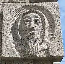
Saint Helier is named for Helier (or Helerius), a 6th-century ascetic hermit. The traditional date of his martyrdom is AD 555. His feast day, marked by an annual municipal and ecumenical pilgrimage to the Hermitage, is on 16 July.
The medieval hagiographies of Helier, the patron saint martyred in Jersey and after whom the parish and town are named, suggest a picture of a small fishing village on the dunes between the marshy land behind and the high-water mark.
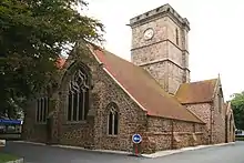
Although the Parish Church of St Helier is now some considerable distance from the sea, at the time of its original construction it was on the edge of the dunes at the closest practical point to the offshore islet called the Hermitage (site of Helier's witness and martyrdom). Before land reclamation and port construction started, boats could be tied up to the churchyard wall on the seaward side.
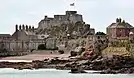
An Abbey of St Helier was founded in 1155 on L'Islet, a tidal island adjacent to the Hermitage. Closed at the Reformation, the site of the abbey was fortified to create the castle that replaced Mont Orgueil as the island's major fortress. The new Elizabeth Castle was named after the Queen by the Governor of Jersey 1600–1603, Sir Walter Raleigh.
18th century
Until the end of the 18th century, the town consisted chiefly of a string of houses, shops and warehouses stretching along the coastal dunes either side of the Church of St Helier and the adjacent marketplace (since 1751, Royal Square). La Cohue (a Norman word for courthouse) stood on one side of the square, now rebuilt as the Royal Court and States Chamber (called collectively the States Building). The market cross in the centre of the square was pulled down at the Reformation, and the iron cage for holding prisoners was replaced by a prison gatehouse at the western edge of town.
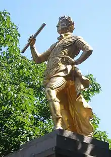
George II gave £200 towards the construction of a new harbour - previously boats would be beached on a falling tide and unloaded by cart across the sands. A statue of the king by John Cheere was erected in the square in 1751 in gratitude, and the market place was renamed Royal Square, although the name has remained Lé Vièr Marchi (the old market) to this day in Jèrriais. Many of St Helier's road names and street names are bilingual English/French or English/Jèrriais, but some have only one name. The names in the various languages are not usually translations: distinct naming traditions survive alongside each other.
The Royal Square was also the scene of the Battle of Jersey on 6 January 1781, the last attempt by French forces to seize Jersey. John Singleton Copley's epic painting The Death of Major Pierson captures an imaginative version of the scene.
As harbour construction moved development seaward, a growth in population meant that marshland and pasture north of the ribbon of urban activity was built on speculatively. Settlement by English immigrants added quarters of colonial-style town houses to the traditional building stock.
Continuing military threats from France spurred the construction of a citadel fortress, Fort Regent, on the Mont de la Ville, the crag dominating the shallow basin of St Helier.
19th century
Military roads linking coastal defences around the island with St Helier harbour allowed farmers to exploit Jersey's temperate micro-climate and use new fast sailing ships and then steamships to get their produce to the markets of London and Paris before the competition. This was the start of Jersey's agricultural prosperity in the 19th century.
The early 19th century was a period of growth of trade for Jersey. An English Custom House was established in the island in 1810. A key turning point in St Helier history was the inttoduction of steamships. Previous to that, travel to the island was long and unpredictable. In the mid-1820s, the post office switched to steam as well. The first paddle steamer to visit Jersey was the Medina on 11 June 1823. In 1824, two shipping companies were established, each operating weekly steamship services to England.[3]:239
This brought thousands of passengers to the town. By 1840, there were 5,000 English residents in Jersey, who some say did not mix well or interact deeply with the native Jèrriais. The number of English-speaking soldiers stationed on the island and the number of retired officers and English-speaking labourers who came to the islands in the 1820s led to the island gradually moving towards an English-speaking culture in St Helier. This new immigration had a large impact on local architecture, with a number of mainland Georgian-style houses and terraces erected on the main roads out of the town. It also expanded with many new streets, such as Burrard Street, first developed in 1812. In 1831, street lighting was first used.[3]:239–40
In the second half of the 19th century, hundreds of trucks laden with potatoes and other export produce needed access to the harbour. This prompted a programme of road-widening which swept away many of the ancient buildings of the town centre. Pressure for redevelopment has meant that very few buildings remain in urban St Helier which date to before the 19th century, giving the town primarily a Regency or Victorian character.
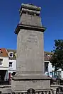
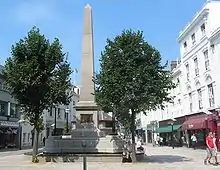
Pierre Le Sueur, reforming Constable of St Helier, was responsible for installing sewerage and provision of clean water in St Helier following outbreaks of cholera in the 1830s. An obelisk with a fountain in the town centre was raised to his memory following his premature death in office from overwork.
20th century
In the 1960s, income from the Jersey States Lottery was used to excavate a two-lane road tunnel under Fort Regent, enabling traffic from the harbour to the east coast towns to avoid a tortuous route around the fort. About the same time, the Fort was converted into a major leisure facility and was linked to the town centre by a gondola cableway - closed and demolished in the 1990s.
In the 1970s, a programme of pedestrianisation of the central streets was undertaken.
In 1995, to celebrate the 50th anniversary of Jersey's liberation from Nazi occupation, and thus 50 years of peace, a sculpture was erected in what is now called "Liberation Square", in front of the Pomme d'Or Hotel, the focal point for the celebrations when the island was liberated.
The sculpture was originally to depict islanders releasing doves of peace, but this came under fierce criticism, with some islanders remarking that had any doves been on the island during the occupation, they would have been eaten by starving German soldiers. Therefore, the sculpture was revised to show islanders raising the British flag, as they had done on the day of liberation 50 years previous.
21st century
Liberation Square is now a focal point in the town - the former terminus of the Jersey Railway housed the Jersey Tourism office until 2007.
In 2006, it was reported[4] that the Connétable, with the backing of the Chief Minister of Jersey, was to seek city status for St Helier.
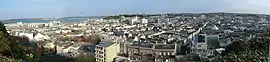
Geography
St Helier is one of the twelve parishes of Jersey and is the most populated of them. It is located on the south coast of the island, on the eastern end of St Aubin's Bay. It covers the majority, and the principal part of, the island's principal settlement (henceforth referred to as "the town"). However, a large part of the parish is rural.
The town has no clearly defined boundary and does not directly match to any parish boundaries. The 2011 Island Plan defines the built-up area as including a large part of the Southern part of the parish (the contiguous built-up area within the parish, notably excluding parts of Mont à l'Abbé, Le Mont au Prêtre, Grands Vaux and St Andrews), a part of St Saviour (however not the Five Oaks area, despite being part of a contiguous urban area) and the Georgetown-Plat Douet area of St Saviour and St Clement.[5] Most of the town is located on low-lying land, consisting of escarpment and flood plain.[6]
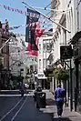
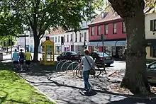
The town's centre is located entirely within the Parish of St Helier, and mostly consists of the area surrounding the town's high street, King Street and Queen Street. It also contains the Parade Cenotaph, Town Church, Town Hall, Royal Square, Victorian Market, the States Chamber and Liberation Square. The town centre is the central business district for the island, containing the principal retail and finance companies.
The parish has a population of 33,522[7] and a land area of 10.6 km2, making it the densest parish on the island.
The topography of the parish consists of a number of hills and valleys. From west to east they are:
- Mont Cochon
- Bellozane Valley
- Westmount
- A very short unnamed valley between Westmount and Mont à l'Abée
- Mont à l'Abée
- La Vallée des Vaux
- Trinity Hill / Le Mont au Prêtre
- Grands Vaux
In the south east of the parish there is also Le Mont de Ville, also referred to as Mount Bingham or South Hill. This divides the Havre des Pas district from the Esplanade area.
Le Grand Douet runs underneath the parish from the north near Grands Vaux, out near the Underpass (pictured below).
Since the 1980s, a significant reclamation project has extended the southern area of St Helier - the area now known as the Waterfront. The A1 dual carriageway was upgraded and extended, with a new grade-separated roundabout junction, the first of its kind in the Channel Islands.
Architecture
The town is not particularly visible from the island's countryside due to the position of the town in a sheltering landscape. The parish has a number of character areas:[6]
- West Esplanade and Elizabeth Castle is defined by extensive panoramic views of St Aubin's Bay and the sea and architecturally dominated by Elizabeth Castle.
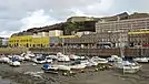
- La Collette consists of mostly reclaimed ground surrounded on three sides by the sea. Its primary usage is industrial and it holds the iconic landmark of La Collette power station chimney, visible across St Helier.
- Havre des Pas is one of the most distinctive and pleasant areas of the town. Predominantly historical architecture with a seaside town flavour.
- Fort Regent – its sillhouette is one of the most recognisable images of St Helier. It is an iconic landmark, significant historic site and major leisure facility.
- Old Harbours has a distinctive identity as a historic harbour area, with open public spaces such as Liberation Square. The piers and harbour structures originate from the early 19th century.
- New Waterfront – on mostly reclaimed land. Distinguishable from the rest of town, consisting of contemporary architecture and a lack of traditional street layout. Home to a leisure centre, modern apartments and office spaces and a number of green spaces.
- The Parade and Esplanade is the historic built edge of the town. A mix of historic, post-war and modern buildings. It hosts the General Hospital and the Parade Gardens.
- Town Centre Core, the civic heart of St Helier, has a network of pedestrianised streets and public spaces, as well as a number of significant landmarks.
- Town Centre North is predominantly residential, home to St Thomas' Church, Springfield Stadium and the Millenium Town Park.
- Town Centre Edges and Slopes hosts predominantly suburban low-density residential, with a notable landmark being Victoria College.
Climate
Under the Köppen climate classification, Saint Helier has an oceanic climate, however, it exhibits characteristics of a mediterranean climate, with a dry summer trend.[8] St Helier has cool, wet winters and mild summers with moderate rainfall. Summers on the island tend to be sunnier, but generally cooler than Southern England. January is the coldest month with an average high of 9.5 °C (49.1 °F), and a low of 4 °C (39 °F). August is the warmest month, with an average high of 21 °C (70 °F), and a low of 14 °C (57 °F). December is the wettest month with 111 mm (4.37 in) of rain, and July is the driest month with 37 mm (1.46 in). Snow is rare. Average Sunshine hours are around 1930 annually. In 2016, Saint Helier reported the highest temperature in the United Kingdom for that year, reaching 35.2 °C (95.4 °F) on 19 July.[9] Saint Helier also set the record for the most sunshine ever reported in one calendar year in the British Isles, at 2340 hours in 1893.[10]
| Climate data for St Helier, United Kingdom | |||||||||||||
|---|---|---|---|---|---|---|---|---|---|---|---|---|---|
| Month | Jan | Feb | Mar | Apr | May | Jun | Jul | Aug | Sep | Oct | Nov | Dec | Year |
| Average high °C (°F) | 9.5 (49.1) |
9.7 (49.5) |
10.9 (51.6) |
13.2 (55.8) |
16.6 (61.9) |
19.2 (66.6) |
21.1 (70.0) |
21.2 (70.2) |
19.3 (66.7) |
15.7 (60.3) |
11.9 (53.4) |
10.4 (50.7) |
14.9 (58.8) |
| Average low °C (°F) | 4.3 (39.7) |
4.0 (39.2) |
5.4 (41.7) |
6.6 (43.9) |
9.4 (48.9) |
11.8 (53.2) |
14.0 (57.2) |
14.4 (57.9) |
12.9 (55.2) |
10.6 (51.1) |
7.4 (45.3) |
5.5 (41.9) |
8.9 (48.0) |
| Average precipitation mm (inches) | 90.4 (3.56) |
73.6 (2.90) |
70.8 (2.79) |
54.4 (2.14) |
52.0 (2.05) |
48.6 (1.91) |
37.0 (1.46) |
45.6 (1.80) |
70.3 (2.77) |
92.2 (3.63) |
107.9 (4.25) |
110.5 (4.35) |
853.3 (33.61) |
| Average precipitation days (≥ 0.2 mm) | 19.0 | 15.9 | 16.3 | 13.3 | 12.2 | 10.7 | 9.9 | 10.1 | 13.3 | 17.0 | 19.2 | 19.5 | 176.4 |
| Source: World Meteorological Organization (UN)[11] | |||||||||||||
Demographics
Saint Helier is the most populated of Jersey's parishes, with 33,522 residents according to the 2011 census.[7]
| Year | Pop. | ±% |
|---|---|---|
| 1991 | 28,123 | — |
| 1996 | 27,523 | −2.1% |
| 2001 | 28,310 | +2.9% |
| 2011 | 33,522 | +18.4% |
Governance
Subdivisions
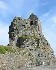
.JPG.webp)
The parish is divided into vingtaines for administrative purposes:
- La Vingtaine de la Ville
- La Vingtaine du Rouge Bouillon
- La Vingtaine de Bas du Mont au Prêtre
- La Vingtaine de Haut du Mont au Prêtre
- La Vingtaine du Mont à l'Abbé
- La Vingtaine du Mont Cochon
For electoral purposes, the parish is divided into 4 districts.
- St Helier No. 1 (comprising the Vingtaine de la Ville) elects 3 Deputies
- St Helier No. 2 (comprising the Vingtaine de Bas du Mont au Prêtre and Vingtaine de Haut du Mont au Prêtre) elects 3 Deputies
- St Helier No. 3 (comprising the Vingtaine du Rouge Bouillon and Vingtaine du Mont à l'Abbé)
- St Helier No. 4 (comprising the Vingtaine du Mont Cochon)
- votes from polling stations in Nos. 3 and 4 are combined into one district electing 4 Deputies. This district is the largest constituency in the island.
The proposed reform of the States Assembly would mean that St Helier will be split into three districts, each with four representatives, except St Helier Central with five representatives.[12]
With the Constable, the parish, therefore, has 11 representatives in the States of Jersey (out of 53 elected members).
Administration
The Parish has its own responsibilities and elections to the Municipality of St Helier take place to elect honorary officials who fulfil a variety of roles for Parishioners under the overall control of the Constable, two Procureurs du Bien Public and the Parish Assembly.
Five members of the Roads Committee and ten Roads Inspectors are also elected by parishioners and ensure that the roads of the parish are kept in good repair.
The members of the Assessment Committee are elected to agree the rate chargeable to each property in the Parish.
The Accounts Committee are elected to ensure that the accounts of the Parish represent a 'true and fair view' of the state of the Parish finances in order that the Parish Assembly may rely upon the information to set the Parish Rate.
Elected officials are supported by a paid administration within the Parish.
Honorary Police of St Helier
All parishes of Jersey, including St Helier, have an Honorary Police force.
Conseil Municipal
The Conseil Municipal is a new municipal council for St Helier. The idea of creating a council was first floated in 1892, however, the idea was not put into place until November 2019, when it was agreed to establish a Shadow Conseil to trail the idea in 2020. The idea is to help the Parish to deliver the Parish Objectives.
It is composed of:
- The Constable
- The Procureurs du Bien Public
- Roads Committee members
- One elected youth members
- Four other members to be elected
Public squares and parks
The Weighbridge
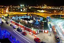
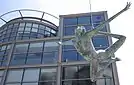
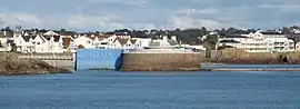
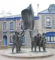
The Weighbridge is a public space in the south of town. The modern space consists of three squares, trisected by La Route de la Libération and the Esplanade. The Weighbridge is notable for being the site of the Liberation of Jersey, when British soldiers raised the Union Flag at the Pomme D'Or hotel, bringing a return to British rule in the island after five years under Nazi occuptation. The site is still the focal point for annual Liberation Day celebrations.
The site is on reclaimed land and has served many purposes over the years. The initial weighbridge was constructed in 1825. The town terminus of the Jersey Railway was opened here in 1870. A statue of Queen Victoria was initially located in what is now Weighbridge Place (it has been relocated to Victoria Park at West Park). This area also served as the island's bus terminus until the opening of Liberation Station in 2005.[13]
In the 1990s, Liberation Square was built in front of the Pomme D'Or for the 50th anniversary of Liberation. It features a statue of islanders holding up a Union Flag. The circular forms of the square represent free thought and liberation. There is a moat around the statue representing the sea and twelve representing the parishes of the island.[14]
The Parade
The Parade is a wide area in the west of St Helier, incorporating a park in the centre and roads around most of the edges. The area is home to the Cenotaph and General Hospital. It is known as Les Mielles in Jèrriais, meaning sand dunes.[15]
It was initially a drilling ground for the island's troops. The original hospital building was completed in 1768, but was originally used as barracks.[16] The Cenotaph was constructed in 1923 to commemorate those islanders who lost their lives in the First World War (however has also been expanded to the Second World War), designed by Charles de Gruchy. It is the focal site for Rememebrance Day celebrations on the island.[17][18]
Millenium Town Park
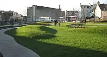
This is the newest park in St Helier, opened on the site of a former car park in 2013. Its creation was initially agreed in 2000, however, plans stalled due to a lack of funds.[19] The park has water features, sculptures, a playground and an area to play ball games. It also has a cycle path through the centre of it.
The site has contributed to local regeneration, with new developments nearby such as Merchant's Square[20] and the Gas Place development.[21]
Charing Cross
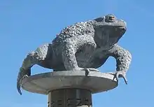
Formerly the site of the prison in the 17th century, Charing Cross is a square at the western end of King Street. There is a monument of a Toad ("Le Crapaud"). It was erected in 2004 as part of the commemoration of 800 years of allegiance to the English Crown. On the side, there are inscribed extracts from the Code Le Geyt. Across the road, there is La Croix de la Reine, a cross erected to commemorate the Queen's Silver Jubilee in 1977.[22] Recently, the Co-operative building on the square was redeveloped, with a new food store and the island's first Premier Inn.[23]
Landmarks
Many places in St Helier have been formally listed as Sites of Special Interest by the Planning and Environment department of Jersey.[24]
Fort Regent
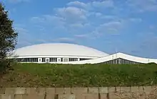
Fort Regent is located at the top of the Mont de la Ville. It was initially constructed as a barracks at the end of the Napoleonic Wars. It was decided to develop it into a leisure complex in 1967. There was a cable car that gave access to Fort Regent from Snow Hill, however, it was closed in 1991. There used to be a swimming pool which opened in 1971 however was knocked down in 2020.[25][26]
A tunnel (A17) was opened under the Fort on 25 February 1970 after seven years of construction.[27] The tunnel links traffic from the east to the west of the island, and allowed for the pedestrianisation of the town centre.
Central Market and Beresford Market
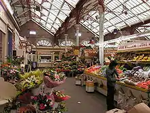
Central Market, in Beresford Street, St Helier, is an indoor market which was opened in 1882.[28] It is an official Site of Special Interest,[29] and is popular with tourists and locals. It features Victorian architecture including cast iron structures, and an ornamental fountain in the centre. The market was designed by Thomas Helliwell of Brighouse, Yorkshire, working with Bellamy and Hardy of Lincoln.[30][31] The market comprises stalls selling flowers, fruit and vegetables, as well as small shops and cafés.
Beresford Market is a separate building next to the Central Market and specialises in fishmongery.[32]
16 New Street
This is an 18th-century Georgian townhouse, with some 19th century additions, which has been renovated by the National Trust for Jersey, and is now operated as a museum.[33][34]
Transport
The primary road network in the parish consists of the St Helier Ring Road (part of which is located in St Saviour) and a series of A roads branching from there to the surrounding parishes, such as Victoria Avenue. Under Fort Regent there is a road tunnel that connects the West and the East of the island together.
The parish is responsible for the upkeep of by-roads (chemins vicinaux) within its boundaries, managed by the Roads Committee. The Government is responsible for main roads.[35]
The parish contains Liberation Station, the bus terminus for the island's public transport network. Every bus route on the island terminates in St Helier and the parish has bus connections to every settlement on the island.[36] A number of bus services provide a direct connection to Jersey Airport in St Peter.
The parish contains the island's main port, with ferry services to Saint-Malo, Poole and Portsmouth.
Twin towns and sister cities
Saint Helier is twinned with:
Culture
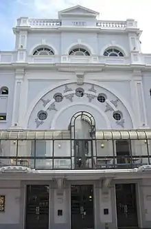
Saint Helier contains cultural facilities at the Jersey Museum, the Maritime Museum, the Jersey Opera House, the Jersey Arts Centre, the performance venue of St James, the sports and entertainment facilities at Fort Regent, the Jersey Library, the library of La Société Jersiaise and the Jersey Archive.
The parish has hosted the Jersey Battle of Flowers carnival since 1902.
Sport
The parish has a number of sports facilities, including Springfield Stadium (incorporating the island's football pitch), Aquasplash (swimming pool), pétanque pitches, badminton and the Fort Regent leisure centre. Motorsports events take place on roads in the Parish as well as an annual Town Criterium, and the start and finish of the Jersey Marathon.
Notable people
- Sir George Carteret (b. 1610), royal statesman, slave trader and first lord proprietor of the British colony of New Jersey, born in St. Helier.[39]
- Henry Cavill (b. 1983), actor, known for playing Superman in the DC Extended Universe, and Geralt of Rivia in The Witcher.
References
- "Members". Statesassembly.gov.je. Retrieved 4 October 2012.
- "States of Jersey - Revised 2011 Island Plan - 4 Built Environment". consult.gov.je. Retrieved 10 December 2020.
- Syvret, Marguerite (2011). Balleine's History of Jersey. The History Press. ISBN 978-1860776502.
- Jersey Evening Post, 5 August 2006
- "ArcGIS Web Application". www.arcgis.com. Retrieved 10 December 2020.
- Jersey, States of. "Government of Jersey". gov.je. Retrieved 10 December 2020.
- "Jersey Census 2011" (PDF). Retrieved 4 October 2012.
- "The Weather in Jersey". Fly Jersey.
- https://www.trevorharley.com/hottest-day-of-each-year-from-1875.html
- https://www.trevorharley.com/1949.html
- "World Weather Information Service - St Helier". May 2011. Retrieved 5 February 2013.
- https://statesassembly.gov.je/assemblypropositions/2020/p.139-2020%20amd(4).pdf
- "A history of bus services in Jersey - theislandwiki". www.theislandwiki.org. Retrieved 12 December 2020.
- "Saint Helier - Jersey Liberation Sculpture". statues.vanderkrogt.net. Retrieved 12 December 2020.
- Dictionnaithe Angliais-Jèrriais : EnglishJèrriais dictionary. Jèrri [Channel Islands]: Don Balleine Trust. 2008. ISBN 1-904210-09-0. OCLC 320341131.
- "The Parade - theislandwiki". www.theislandwiki.org. Retrieved 10 January 2021.
- "The Channel Islands and The Great War". www.greatwarci.net. Retrieved 10 January 2021.
- "The Cenotaph - theislandwiki". www.theislandwiki.org. Retrieved 10 January 2021.
- "Jersey's Millennium town park opens after 13-year wait". BBC News. 29 October 2011. Retrieved 12 December 2020.
- "£70million Bath Street project approved". Le Masurier. 18 October 2019. Retrieved 12 December 2020.
- "Gas Works Site". Retrieved 12 December 2020.
- Charing Cross (Sign in square). Parish of St Helier. 2020.
- "Charing Cross - Jersey | Channel Islands Co-operative". www.channelislands.coop. Retrieved 17 December 2020.
- "Sites of special interest (SSIs)". Gov.je. 26 July 2012. Retrieved 4 October 2012.
- "Fort Regent - theislandwiki". www.theislandwiki.org. Retrieved 12 December 2020.
- Taylor, Ed. "Fort Regent pool building to be demolished at a cost of £2.69m". jerseyeveningpost.com. Retrieved 12 December 2020.
- "Route du Fort - theislandwiki". www.theislandwiki.org. Retrieved 10 January 2021.
- Parishes
- "Central Market - Flooring". Archived from the original on 25 August 2006.
- Jersey Independent and Daily Telegraph - Saturday 15 May 1880 Pg 2
- "Markets - theislandwiki". www.theislandwiki.org.
- "Jersey Markets Information". Thisisjersey.com. Retrieved 4 October 2012.
- "Historic environment details". Mygov.je. Retrieved 11 October 2012.
- "16 New Street | The National Trust for Jersey". Nationaltrust.je. 26 April 2012. Retrieved 11 October 2012.
- "Parishes - Roads". parish.gov.je. Retrieved 10 December 2020.
- Liberty Bus Route Map, Winter 2020 http://liberty-admin.nabxtmim3c.eu-west-2.elasticbeanstalk.com/api/v1/files/269/resolve
- "St Helier 'twinned' with Madeiran capital Funchal". BBC News. Retrieved 4 June 2019.
- "Trenton twinning tourism boost for Jersey?". Jersey Evening Post. 29 November 2019. Retrieved 29 November 2019.
- "Sir George Carteret, Baronet | British politician". Encyclopedia Britannica. Retrieved 15 October 2020.
Bibliography
- Balleine's History of Jersey, Marguerite Syvret and Joan Stevens (1998) ISBN 1-86077-065-7.
- Jersey in Figures, 2003–2004, published by the States of Jersey.
External links
| Authority control |
|---|