List of transcontinental countries
This is a list of countries located on more than one continent, known as transcontinental states or intercontinental states. While there are many countries with non-contiguous overseas territories fitting this definition, only a limited number of countries have territory straddling an overland continental boundary, most commonly the line that separates Europe and Asia.
The boundary between Europe and Asia is largely conventional, and several conventions remained in use well into the 20th century. However, the now-prevalent convention, used for the purposes of this list, follows the Caucasus northern chain, the Ural River and the Ural Mountains. It has been in use by some cartographers since about 1850.[1] This convention results in several countries finding themselves almost entirely in "Asia", with a few small enclaves or districts technically in "Europe". Notwithstanding these anomalies, this list of transcontinental or intercontinental states respects the convention that Europe and Asia are full continents rather than subcontinents or component landmasses of a larger Eurasian continent.
Listed further below, separately, are countries with distant non-contiguous parts (overseas territories) on separate continents.
Criteria for inclusion
The lists within this article include entries that meet the following criteria:
- Transcontinental states are sovereign states that are divided between one geographical continent and another.[2]
- In this article, states are classed as contiguous or non-contiguous transcontinental states.[3]
- Contiguous transcontinental states are states that contain a portion of their territory on one continent and a portion of their territory on another continent, while having these two portions connected via a natural geological land connection (e.g. Russia) or the two portions being immediately adjacent to one another (e.g. Turkey).[4][5]
- Non-contiguous transcontinental states are states that contain a portion of their territory on one continent and a portion of their territory on another continent, while having these two portions separated by a significant enough distance, or body of water, to not be considered adjacent.[4][5]
- For the purposes of the lists within this article, a seven-continent model is assumed.[6]
- Debate exists on the degree to which many non-contiguous transcontinental states can be considered 'transcontinental', due to portions of their territory often lying on distant islands that could be considered a part of another nearby continent. The boundaries between the continents can be vague and subject to interpretation. For the purposes of the lists in this article, a state that has such a situation where this could be applicable is to nevertheless be included in the lists (e.g. Socotra, Yemen and Madeira, Portugal).
- Debate exists on the degree to which states that only have uninhabited island territory as a part of another continent can be considered transcontinental. They are nevertheless included in these lists (e.g. Aves Island, Venezuela).
- Debate exists on the degree to which states that have claimed territory within the Antarctic Treaty System can have actual control of that claimed territory. They are included in these lists (e.g. Chilean Antarctic Territory, Chile).
- Debate exists on the degree to which states that have territory on another continent that is an autonomous region, and is not constitutionally an indistinguishable part of the parent state (a dependent territory), can be considered to be transcontinental. They are nevertheless included in these lists (e.g. British Overseas Territories, the United Kingdom).
Exceptions:
- Micronations, autonomous regions, and sub-national entities of sovereign states, if they are in themselves transcontinental, are to be excluded from the lists in this article as a separate entry from a controlling state.
- States that have territory across sub-continental boundaries, and plate boundaries internal to continents, are excluded from these lists as these do not constitute being transcontinental in the seven-continent model.
- States with limited recognition are excluded from the lists in this article, and any entry must be a UN member state or a part of the United Nations System.
Contiguous boundary
Africa and Asia
The modern convention for the land boundary between Asia and Africa runs along the Isthmus of Suez and the Suez Canal in Egypt. The border continues through the Gulf of Suez, Red Sea and Gulf of Aden. In antiquity, Egypt had been considered part of Asia, with the Catabathmus Magnus escarpment taken as the boundary with Africa (Libya).
- Egypt: Two of 27 governorates of Egypt lie entirely on the Asian Sinai Peninsula and two are transcontinental: Ismailia Governorate is nearly equally divided by the Suez Canal, and Suez Governorate, which is coterminous with the "transcontinental city" of Suez, has a small portion east of the Canal.
Former transcontinental state
- Israel: After the Yom Kippur War of October 1973, Israel briefly became a transcontinental state as it occupied territory on the African side of the Suez Canal, in addition to the entirety of Sinai. The land was returned in 1975 per the Sinai Interim Agreement.
Asia and Europe
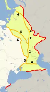
The conventional Europe-Asia boundary was subject to considerable variation during the 18th and 19th centuries, indicated anywhere between the Don River and the Caucasus to the south or the Ural Mountains to the east. Since the later 19th century, the Caucasus–Urals boundary has become almost universally accepted. According to this now-standard convention, the boundary follows the Aegean Sea, the Turkish Straits, the Black Sea, along the watershed of the Greater Caucasus, the northwestern portion of the Caspian Sea and along the Ural River and Ural Mountains to the Arctic Ocean.[7][8]
According to this convention, Azerbaijan, Georgia, Kazakhstan, the Russian Federation, and the Republic of Turkey have territory in both Asia and Europe.
- Azerbaijan: Azerbaijan is a country located mainly on the Asian portion of the Caucasus; however, its Qusar, Shabran, Siazan, Khachmaz and Quba districts are north of the Greater Caucasus Watershed, and thus geographically in Europe, placing a population of about half a million (or ca. 5% of the country's total population) in Europe.
- Georgia: Georgia is a country located mainly on the Asian portion of the Caucasus, with its Kazbegi Municipality, Khevsureti and Tusheti north of the Greater Caucasus Watershed, and thus geographically in Europe, placing around 5% of the country's total territory in Europe.
- Kazakhstan: Kazakhstan is a country mainly located in Central Asia with a small portion of the country extending west of the Ural River in Eastern Europe. The country's physical, cultural, ethnic, and geographic characteristics are Central Asian,[9] with a large European influence and influx of European settlers from Russia from when it was a part of the Soviet Union and the earlier Russian Empire. Its West Kazakhstan and Atyrau regions extend on either side of the Ural River,[10] placing a population of less than one million residents (out of a 15 million total population) geographically in Europe.
- Russia: The Russian Federation is located in Eastern Europe with substantial territory in Northern Asia, which was historically incorporated into the Tsardom of Russia in the 17th century by conquests. Although Russia falls partly in Asia, it is considered a European country because of its historical, cultural, ethnical, and political ties to the continent. The vast majority of its population (80%) lives within its European portion, making it the most populous European nation. Russia's capital Moscow is the largest city in Europe.
- Turkey: The Republic of Turkey falls almost wholly within the Anatolian Peninsula in Western Asia (the Middle East), with a small portion of the country in the Balkan Peninsula in Southeastern Europe called East Thrace, which covers only 3% of the country's total area, with a population of about 11 million people, or some 14% of the country's population. Turkey's largest city Istanbul spans either side of the Bosphorus, making it a "transcontinental city" in both Europe and Asia, while the country's capital Ankara is located in Asia. The territory of the current Turkish state is the core territory of the previous Ottoman Empire that was also transcontinental in the same geographic region, which itself had also supplanted the earlier, similarly transcontinental Byzantine Empire.
North America and South America
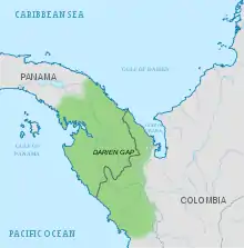
The conventional boundary between North America and South America is at some point on the Colombia–Panama border, with the most common demarcation in atlases and other sources following the Darién Mountains watershed where the Isthmus of Panama meets the South American continent (see Darién Gap). This area encompasses a large watershed, forest and mountains in the northern portion of Colombia's Chocó Department and Panama's Darién Province.
- Panama: Since the political boundary between Panama and Colombia is not entirely determined by natural features, some geographers prefer to use the Panama Canal[11] as the physical boundary between North America and South America instead.[12] Under this convention, Panama is classified as a transcontinental country while its capital Panama City is classified as a South American city.
Non-contiguous
North America and South America
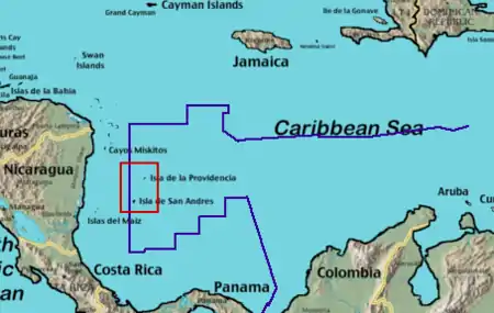
- Colombia: Most of Colombia, predominantly its mainland, is located in northern South America (see North America and South America above) and the Malpelo Island in the Pacific Ocean is also associated with South America, but the state also administers the San Andrés and Providencia archipelago, 640 kilometres (400 mi) WNW of Colombia's Caribbean Coast, in North America.
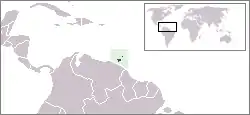
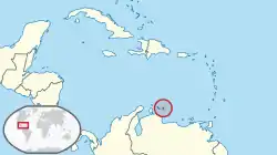
- Venezuela (Aves Island): Most of Venezuela, predominantly its mainland, is located in northern South America, but Aves Island is geographically a definitive part of North America. Aves Island is one of the Federal Dependencies of Venezuela which are under the administration of the Ministry of Interior, Justice and Peace.
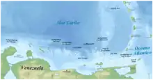
The special case of Caribbean islands adjacent to the South American coastline
- Trinidad and Tobago: The state of Trinidad and Tobago lies on two tectonic plates. The southern half of Trinidad lies on the South American Plate while the northern half of Trinidad and the island of Tobago lie on the Caribbean Plate. However, these geological features do not necessarily qualify Trinidad and Tobago as a transcontinental state, as the whole territory is often labeled geopolitically as part of North America.
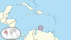
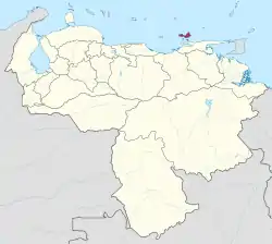
- Leeward Antilles (Collectively Aruba, Bonaire, and Curaçao of the Netherlands, Nueva Esparta of Venezuela, and the Federal Dependencies of Venezuela, excluding Aves Island): The Caribbean islands division of North America and South America is complicated. Geopolitically, all Caribbean islands in the West Indies are often labeled as North American islands, but geologically, the islands of the Leeward Antilles lie on the continental shelf of South America, and can be considered South American as well. Excluding the geographically North American Aves Island, the remaining Venezuelan islands of the Federal Dependencies are islands situated in the Caribbean Sea on the continental shelf of South America. These islands are north of the Venezuelan mainland and are akin to the location of Aruba, Bonaire, Curaçao, and Trinidad and Tobago. Similarly, the islands of the State of Nueva Esparta (Margarita Island, Coche Island, and Cubagua) are also situated in the Caribbean Sea just to the north of the Caribbean coastline of the Venezuelan mainland. However, all of the non-Venezuelan islands in this area are typically considered North American rather than South American.
Caribbean Island Locations
North American Caribbean islands administered by South American states:
Caribbean islands considered North American or South American:

.svg.png.webp)
North America, Oceania, and Asia
- United States: While the territory of the United States lies overwhelmingly in North America, it includes the state of Hawaii in Oceania as well as other Oceanian island possessions and Alaskan islands on Northeast Asia's continental shelf.
South America and Oceania
- Chile: Chile is mostly on the South American mainland and includes the Oceanian islands of Easter Island and Isla Salas y Gómez Island. Those and the outlying South American Juan Fernández Islands and Desventuradas Islands are part of the Valparaíso Region.
- Ecuador: Ecuador contains the Galápagos Islands, which, depending on the definition, either lie in South America or as a part of the Oceanian islands.
Europe and North America
- Denmark: As a constituent part of the Danish Realm, Greenland is a non-sovereign country within the Kingdom of Denmark. Fully located on the North American tectonic plate, and close to the mainland, Greenland is considered to be geographically a part of North America. Although it is politically associated with Europe and internationally represented by a European state (including in the Council of Europe), it is autonomous. Historically and ethnically, its native population is of North American tradition, although it also shares cultural links with other native peoples bordering the Arctic Sea in Northern Europe and Asia (today in Norway, Sweden, Finland and Russia), as well as in North America (Alaska in the U.S., Northwest Territories, Nunavut and northern parts of Quebec and Labrador in Canada). Greenland was part of Danish territory and within the territory of the European Union, but voted for more autonomy and is now excluded from the EU.
Europe, North America, and South America
- Netherlands: Though most of the Kingdom of the Netherlands' landmass is in Europe, it also includes six island territories in the Lesser Antilles archipelago of the Caribbean Sea: the Dutch Caribbean. Within the Lesser Antilles archipelago, three territories are in the Leeward Islands group (considered part of the continent of North America) and three in the Leeward Antilles group (on the South American continental shelf). Since the dissolution of the Dutch Antilles in 2010, the sovereign Kingdom of the Netherlands has been administratively divided into four non-sovereign constituent "countries": Aruba, Curaçao, Sint Maarten and the Netherlands — the last of which includes the islands of Bonaire, Saint Eustatius and Saba (collectively known as the BES islands or the Caribbean Netherlands) as "special municipalities", making it a non-sovereign transcontinental constituent country within the Kingdom.
Europe, North America, South America, Oceania, Africa, and Antarctica
- France: Metropolitan France is located in Europe, while the five overseas departments and regions, five overseas collectivities, and one Sui generis collectivity are located in other continental regions. Guadeloupe, Martinique, Saint Barthélemy, Saint Martin, and Saint Pierre and Miquelon are located in North America, French Guiana is located in South America, Mayotte and Réunion are located in Africa, and French Polynesia, Wallis and Futuna, and New Caledonia are located in Oceania. These 11 populated territories of overseas France are integral parts of France, as are the uninhabited Clipperton Island in North America and the uninhabited French Southern and Antarctic Lands, which include the claimed Adélie Land on the Antarctic mainland, the Crozet Islands and the Kerguelen Islands in the Antarctic region, Saint Paul and Amsterdam Islands on the Australian Plate, and the Scattered Islands in the Indian Ocean. French sovereignty claim on Adélie Land is in abeyance under the Antarctic Treaty System. France has territory in each continental region except Asia.
Europe, North America, South America, Oceania, Africa, Asia, and Antarctica
- United Kingdom: The United Kingdom, located in Northwestern Europe possesses the 'dependent territories' of Anguilla, Bermuda, the British Virgin Islands, the Cayman Islands, Montserrat and the Turks and Caicos Islands are located in North America. The Falkland Islands as well as the South Georgia and the South Sandwich Islands are located in South America, but straddle the bounds of Antarctica. The Pitcairn, Henderson, Ducie and Oeno Islands are located in Oceania. The islands of Saint Helena, Ascension, Tristan da Cunha and Gough are located in Africa. The Sovereign Base Areas of Akrotiri and Dhekelia are located in Asia, and the British Indian Ocean Territory is located in the center of the Indian Ocean between Africa and Asia (geologically a part of South Asia, but geopolitically a part of East Africa). The British Antarctic Territory is located in Antarctica. The United Kingdom is the only state in the world to have territory in each continental region.
Africa and Europe
- Italy: Italy has a number of small islands south of Sicily which, geographically can be considered part of the African continent, due to their proximity to Tunisia. The closest land to Pantelleria and the Pelagie Islands (Lampedusa, Linosa and Lampione) is Tunisia on the African mainland. Nevertheless, Pantelleria and Linosa are considered part of Europe, Lampedusa and Lampione part of Africa.
- Portugal: Continental Portugal is in Europe, while the archipelago of Madeira, an Autonomous Region (including Porto Santo Island, the Desertas Islands and the Savage Islands), is associated with Africa. If the Azores Autonomous Region is considered to be split as two island groups (with the westernmost Flores Island and Corvo Island on the North American tectonic plate being a distinct group from the rest), Portugal would be a transcontinental state geologically (see Europe and North America above). However, geologic tectonic plate separation does not necessarily define geographical continental distinction.
- Spain: Although its mainland is in Europe, Spain has territory including two provinces and two autonomous cities in Africa. Close to 5% of Spain's population live on the African continent. Territories include the Canary Islands in the Atlantic, the cities of Ceuta and Melilla on mainland North Africa and its plazas de soberanía, which are close to those cities that are geographically part of Africa. The Canary Islands, Ceuta and Melilla are three of the 19 autonomous communities and cities that form Spain, while the plazas de soberanía are under a different status, akin to unicorporated territories. The African Mediterranean island of Alboran belongs to the transcontinental city of Almería and the transcontinental province of Almería.
Asia and Africa
- Yemen: Although mainland Yemen is in the southern Arabian Peninsula and thus part of Asia, and its Hanish Islands and Perim in the Red Sea are associated with Asia, Yemen's national territory extends to the archipelago of Socotra, which lies east of the horn of Somalia[13] and is much closer to Africa than to Asia.[14]
Asia and Europe
- Greece: The territory of Greece includes a number of islands just off the coast of Asia Minor, such as Rhodes, Kos, Samos, Chios, Lesbos, Kastellorizo, Strongyli Megistis, and Ro.
Asia and Oceania
- Australia: The Commonwealth of Australia consists of its namesake continent and island possessions associated with Oceania, Asia, and Antarctica. Its Indian Ocean island possessions of Christmas Island and the Cocos (Keeling) Islands are associated with Southeast Asia. The majority of Australia's Asian island residents have Asian ancestry and are Muslims or Buddhists.
- Brunei, East Timor, Indonesia, Malaysia, Papua New Guinea, and the Philippines: The Malay Archipelago, which lies on the border of Melanesia and Southeast Asia, can be considered a transcontinental region. Depending on the interpretation of the border, Indonesia and Malaysia can be considered transcontinental states while Brunei, East Timor, Papua New Guinea, and the Philippines are considered wholly on one side or the other, dependent on the boundary definition. Anthropologically, New Guinea is a part of Melanesia, but it is sometimes included in the Malay Archipelago. The state of Papua New Guinea is an observer in the Association of Southeast Asian Nations (ASEAN), which includes mainland states of Southeast Asia, and has contemplated full membership in this organisation.[15]
- Japan: Japan's Izu islands and Ogasawara Village (consisting of the Ogasawara islands, the Volcano Islands, and three remote islands; Nishinoshima, Minami-Tori-shima and Okinotorishima) are occasionally considered part of Oceania.
Antarctica and other continents
Subantarctic region
- Argentina, Australia, Chile, France, New Zealand, Norway, South Africa, and the United Kingdom: These eight states have overseas island possessions in the Subantarctic region between 46°S and 60°S latitude. Subantarctic islands that are north of 60°S latitude, but south of the Antarctic Convergence, which are recognized by international law as being full sovereign possessions of an administering state are: Bouvet Island (Norway), Heard Island and McDonald Islands (Australia), the Kerguelen Islands (France), and South Georgia and the South Sandwich Islands (United Kingdom).[note 1]
Antarctic region
- Argentina, Australia, Chile, France, New Zealand, Norway, and the United Kingdom: These seven states claim portions of the Antarctic mainland (some of them overlapping)[note 2], as well as its associated islands south of 60°S latitude. Some, including Argentina and Chile, consider the Antarctic land they claim to be integral parts of their national territory. However, none of these claims are recognized by the United Nations and the international community.[note 3] Since 1961, the Antarctic Treaty System has held in abeyance all land claims south of 60°S latitude, including Antarctica's ice shelves and Antarctic islands.
See also
- Boundaries between the continents of Earth
- Dependent territory
- Historical powers
- List of countries by continent
- List of transcontinental empires and countries in history
- Thalassocracy
Notes
- South Georgia and the South Sandwich Islands, which straddles tectonic plates, form a British Overseas Territory but are claimed by Argentina.
- The Antarctic claims of Argentina, Chile and the United Kingdom overlap to some degree.
- Australia, France, New Zealand, Norway, and the United Kingdom recognize each other's Antarctic claims (which do not overlap).[16]
References
- The question was treated as a "controversy" in British geographical literature until at least the 1860s, with Douglas Freshfield advocating the Caucasus crest boundary as the "best possible", citing support from various "modern geographers" (Journey in the Caucasus, Proceedings of the Royal Geographical Society, Volumes 13–14, 1869). In 1958, the Soviet Geographical Society formally recommended that the boundary between Europe and Asia be drawn in textbooks from Baydaratskaya Bay, on the Kara Sea, along the eastern foot of the Ural Mountains, then the Ural River to the Mugodzhar Hills, the Emba River, and the Kuma–Manych Depression (i.e. passing well north of the Caucasus); "Do we live in Europe or in Asia?" (in Russian).; Orlenok V. (1998). "Physical Geography" (in Russian). Archived from the original on 2011-10-16.. Nevertheless, most Soviet-era geographers continued to favour the boundary along the Caucasus crest. (E. M. Moores, R. W. Fairbridge, Encyclopedia of European and Asian regional geology, Springer, 1997, ISBN 978-0-412-74040-4, p. 34: "most Soviet geographers took the watershed of the Main Range of the Greater Caucasus as the boundary between Europe and Asia.")
- "transcontinental". OxfordDictionaries.com. Retrieved 5 February 2019.
- "contiguous". Dictionary.Cambridge.org. Retrieved 5 February 2019.
- Misachi, John (25 April 2017). "Which Countries Span More Than One Continent?". WorldAtlas.com. Retrieved 5 February 2019.
- Ramos, Juan (19 March 2018). "What Continent Is Egypt Officially In?". ScienceTrends.com. Retrieved 5 February 2019.
- "Continent". NationalGeographic.org. National Geographic. Retrieved 5 February 2019.
- National Geographic Atlas of the World (9th ed.). Washington, DC: National Geographic. 2011. ISBN 978-1-4262-0634-4. "Europe" (plate 59); "Asia" (plate 74): "A commonly accepted division between Asia and Europe ... is formed by the Ural Mountains, Ural River, Caspian Sea, Caucasus Mountains, and the Black Sea with its outlets, the Bosporus and Dardanelles."
- World Factbook. Washington, DC: Central Intelligence Agency.
- Encyclopædia Britannica, Kazakhstan, Retrieved: 8 May 2016
- World Factbook. Washington, D.C.: Central Intelligence Agency. Kazakhstan: Geography
- Panama Canal
- North America
- "Socotra". Britannica.com. 6 May 2014. Retrieved 5 February 2019.
- Evans, Mike. "Islands east of the Horn of Africa and south of Yemen". WorldWildlife.org. Retrieved 5 February 2019.
- "Papua New Guinea asks RP support for Asean membership bid". GMA News. Retrieved 15 July 2014.
- "Did you know that seven countries have claims in Antarctica?". Norwegian Polar Institute. Retrieved 30 August 2020.
External links
- Transcontinental states according to World Gazetteer at Archive.today (archived 2012-12-18)