Lower Shawneetown
Lower Shawneetown (15Gp15), also known as the Bentley Site, Shannoah and Sonnontio, is a Late Fort Ancient culture Madisonville horizon (post 1400 CE) archaeological site overlain by an 18th-century Shawnee village; it is located within the Lower Shawneetown Archeological District, near South Portsmouth in Greenup County, Kentucky and Lewis County, Kentucky.[2] It was added to the National Register of Historic Places on April 28, 1983.[1] It is located near four groups of Hopewell tradition mounds, built between 100 BCE and 500 CE, known as the Portsmouth Earthworks.
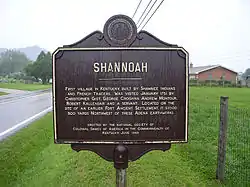 Bronze historical marker near site | |
 Approximate location within Kentucky today | |
| Location | South Portsmouth, Kentucky, Greenup County, Kentucky, |
|---|---|
| Region | Greenup County, Kentucky |
| Coordinates | 38°43′17.76″N 83°1′22.98″W |
| History | |
| Founded | Ca. 1733 |
| Abandoned | 1758 |
| Periods | Madisonville horizon, protohistoric |
| Cultures | Fort Ancient culture, Shawnee people |
| Architecture | |
| Architectural details | Number of monuments: |
Lower Shawneetown | |
| NRHP reference No. | 83002784[1] |
| Added to NRHP | April 28, 1983 |
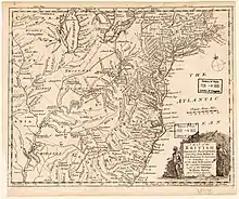
The 18th-century community was "less a village and more of a district extending along the wide Scioto River and narrower Ohio River floodplains and terraces. It was a sprawling series of wickiups and longhouses... French and British-allied traders regarded Lower Shawneetown as one of two capitals of the Shawnee tribe."[3] Between about 1734 and 1758 Lower Shawneetown became a center for commerce and diplomacy, "a sort of republic populated by a diverse array of migratory peoples, from the Iroquois to the Delawares, and supplied by British traders, Lower Shawneetown had become a formidable threat to French ambitions...[and] posed a significant challenge to France and Great Britain alike."[3] Lower Shawneetown was downstream from the much smaller Upper Shawneetown, established about 1751 at the confluence of the Ohio River and the Kanawha River, near present-day Point Pleasant, WV and known to the Shawnees as "Chinoudaista" or "Chinodahichetha."[4][5][6]
Lower Shawneetown was destroyed by floods in November, 1758, and the population relocated to another site further up the Scioto River.[7]
Portsmouth Earthworks
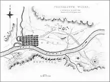
Built between 100 BCE and 500 CE by the Hopewell culture, the earthworks are a large ceremonial center located at the confluence of the Scioto and Ohio rivers.[8] A feature of the site is the "Old Fort Earthworks", a part of the Portsmouth Earthworks known as Group A.[9] The Group B earthworks include a northern section consisting of a number of circular enclosures, two large horseshoe-shaped enclosures, and three sets of parallel-walled roads leading away from this location. One set of walls went to the southwest and may have been linked by an earthen causeway to a large square enclosure located on the Kentucky side of the Ohio River (Group A).
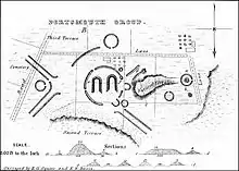
Another set of walls went to the southeast, where it led to the Ohio River. The walls continued on the opposite side of the river and led to a complicated circular enclosure (Groups C and D). The third set of walls went to the northwest for an undetermined distance.[10] Much of the site is now encompassed by the city of Portsmouth.
In 2019 two independent scholars proposed that the Group B mounds represent part of an eight-mile-long female effigy mound, which the authors propose depicts "The Woman Who Fell from the Sky," a Native American myth about human origins found among the indigenous peoples of North America.[11] If true, this would make it the longest effigy mound known, although much of the structure was destroyed by the city of Portsmouth.[12] The authors link the mounds to the story of He-nau-ee, as told by the Meskwaki Indians, possible descendants of the Hopewell mound builders. Other archeologists have cast doubt on the theory.[13]
Fort Ancient settlement, 1400-1625 CE
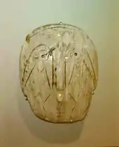
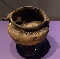
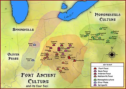
The Bentley site is a 1.2 hectare village on the second flood terrace of the Ohio River, located across from the mouth of the Scioto River.[14] It was excavated in the 1930s and was discovered to have had similar structures and building techniques as those found at another nearby Fort Ancient site, the Hardin Village Site located 13 kilometres (8.1 mi) up the Ohio.[15][16] Also found during the excavations were distinctive Madisonville horizon pottery,[17] including cordmarked, plain and grooved-paddle jars, as well as a variety of chert points, scrapers and ceremonial pipes.[2] The site was inhabited continuously from 1400 to about 1625 CE and probably had a population of 250 to 500 people living in long, rectangular houses covered with bark and shared by multiple families, as indicated by the several central hearths and interior partitions.[18]
Prior to the arrival of Europeans, the community engaged in trade with other villages, as evidenced by the presence in graves of ornamental shell gorgets made from the shells of marine mollusks harvested off the coasts of Florida and the Gulf of Mexico.[19][20] Fort Ancient residents probably obtained these shells by trading salt extracted from boiled brine.[21]
A variety of locally-made tools were recovered from the site, including bone awls, chisels, endscrapers, fishhooks and pins, and some decorative items including pendants, earplugs, and freshwater mussel-shell beads. Tobacco pipes made of stone and ceramic were found, along with a few items of European origin, including copper or brass beads, bracelets, tubes, coils and pendants. These were most likely not obtained directly through contact with Europeans but rather via Native American intermediary trade. Over 300 burials were located, and some skeletons showed signs of tuberculosis, yaws or nonvenereal endemic syphilis.[16][14]
The village was probably abandoned around 1625, possibly because of periodic flooding of the Ohio River.[22] The Fort Ancient residents of southern Ohio were very likely wiped out in the late seventeenth century by infectious diseases brought by Europeans, particularly measles, smallpox, and influenza. Graves from this period often contain multiple burials—from four to over a hundred individuals—reflecting a sudden increase in mortality typical of epidemics.[20] Depopulation may have been hastened by Iroquois raids during the Beaver Wars (1629-1701).[23][5] The region was largely uninhabited when Lower Shawneetown was founded in the early 18th century.[18]
Shawnee village c. 1734-1758
Foundation and names
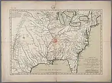
Established in the mid-1730s[24][7]:305 at the confluence of the Scioto and Ohio Rivers, this was one of the earliest known Shawnee settlements on both sides of the Ohio River.[25] Historian Charles A. Hanna proposed that the town was established around 1735 by Shaweygila Shawnees who had been forced out of their home on the Monongahela River by the Six Nations chiefs.[7]:130[23]:29 He states that the first reference to the Lower Shawnee Town by that name was in a letter by William Trent on October 20, 1748 reporting a murder at Kaskaskia, when a Virginia trader there was killed following an altercation over some liquor, "which he was tying up, in order to send to the Lower Shawna Town."[26]
The Shawnee name of the town was not recorded, but scholars believe it may have been "Chalahgawtha" or "Chillicothe," both Shawnee words meaning "principal place"[7]:145–6 and typically applied to villages of the Chalahgawtha division of the Shawnees, who soon dominated the town.[27] On English maps the town was labelled "the Lower Shawonese Town," "the lower Shawanees town," "Lower Shanna Town," "the Shannoah town," or "Shawnoah."[7] The French called it "Saint Yotoc"[28] (which may be a corruption of Scioto), "Sinhioto," "Sononito," "Sonnioto," "Scioto," "Sonyoto," and "Cenioteaux."[28][29]
Population and appearance
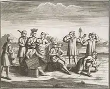
.jpg.webp)
Pressure from the growing European populations on the east coast of North America and in southern Canada had caused Native American populations to concentrate in the Ohio River Valley,[23][30] and Lower Shawneetown was situated at a convenient point, accessible to many communities living on tributaries of the Ohio River. The area had Iroquois, Delaware, Wyandot, and Miami communities within a few days' journey. The town also lay near the Seneca Trail, which was used by Cherokees and Catawbas, and the opportunity to trade for furs and to broker political alliances attracted both British and French traders.[27] Within a few years of its establishment, the town became a key center in dealings between Native American tribes and Europeans.[2][7][31] During the 1740s and 1750s, both the British and the French became increasingly concerned about the growing Native American settlements in the region, including Lower Shawneetown's neighbors, Logstown, Pickawillany, Sandusky, and Kittanning. Historian Richard White characterizes such "Indian republics" as multiethnic and autonomous, made up of a variety of smaller disparate social groups: village fragments, extended families, or individuals, often survivors of epidemics and refugees from conflicts with other Native Americans or with Europeans.[32]
Although mainly a Shawnee village, the population included contingents of Seneca and Lenape.[3] After his visit to Lower Shawneetown in 1749, Céloron de Blainville wrote "this village [is] composed for the most part of Chavenois (Shawnee) and Iroquois of the Five Nations...men from the Sault St. Louis (Kahnawake), there are also some from the Lake of Two Mountains (Mohawks of Kanesatake), some Loups from the Miami (Munsee), and nearly all the nations from the territory of Enhault (Pays d'en Haut, the territory of New France to the west of Montreal)."[33]
Lower Shawneetown was surrounded by fertile, alluvial flatlands that were ideal for growing corn, beans, squash, gourds, tobacco, and sunflowers. The remains of charred Northern flint corn have been documented archaeologically.[20]:20 The area adjacent to the town was rich in natural resources: a mosaic of mixed hardwood forests, flat grassy plains, canebrakes, salt and clear freshwater springs, home to deer, bear, elk, and bison. Wild plants and nut-bearing trees were abundant, and chert-bearing bedrock and clay river banks provided essential materials for tools and pottery.[27]
In a journal entry from February, 1751 Christopher Gist describes the Ohio country in the area of Lower Shawneetown:
All the Way from the Shannoah Town...is fine, rich, level, Land, well timbered with large Walnut, Ash, Sugar Trees, Cherry Trees, &c; it is well watered with a great Number of little Streams or Rivulets, and full of beautiful natural Meadows, covered with wild Rye, blue Grass, and Clover, and abounds with Turkeys, Deer, Elks, and most Sorts of Game, particularly Buffaloes, thirty or forty of which are frequently seen feeding in one Meadow...a most delightful Country. The Ohio and all the large Branches are said to be full of fine Fish of several Kinds, particularly a Sort of Cat Fish of a prodigious Size.[34]
According to A. Gwynn Henderson, eighteenth-century homes in this community would have resembled those of the Fort Ancient inhabitants:
...Long rectangular buildings with rounded corners constructed of frameworks of wooden posts set singly into the ground and covered with either thatch, bark, mats or skins. Trade blankets or skins provided "doors" at the ends of the houses. Interior partitions broke up the space within each house, and hearths were located in the center of earthen floors. Pits for storage lined the walls; trash was disposed in outdoor pits or on the ground in heaps behind the house. Bundles of dried food hung from the rafters. However, Europeans described some buildings as huts, cabins or houses--structures with squared logs and covered with bark or clapboard. A few even had chimneys.[27]:34
In 1749 Joseph Pierre de Bonnecamps estimated that the entire town had about 60 cabins,[35] but by 1751, the town consisted of 40 houses on the Kentucky side located along bluffs above the floodplain, and 100 houses on the Ohio side atop a forty-foot river bank lined with sycamores and willows.[27] In the town center there was a 90 feet (27 m) long council house[25] and a large open area or plaza for public events. Houses were clustered together according to kinship, interspersed with gardens, trash heaps and family burial plots.[27]:34 The remains of 23 individuals have been recovered from 16 graves at the Bentley site, among which there were 19 children and adolescents and four adults.[14] Including its 300 warriors, the town may have had a total population of between 1,200[14][31] and 1,500.[36] In 1753, after a flood destroyed part of the town which had been on the Scioto River's west bank, some residents relocated to the east bank, and others moved to the Kentucky side of the Ohio River.[15][37]
Residents of the town used Raven Rock, a 500-foot-high sandstone rock formation, as a lookout point to observe traffic on the Ohio River. Located about 5.5 miles southwest of the town center, the rock allowed lookouts to survey a 14-mile stretch of the river upstream and downstream.[38]:169 It is today part of Raven Rock State Nature Preserve.[39]
Visit by Peter Chartier, 1745
In April 1745 Peter Chartier and about 400 Shawnees took refuge in Lower Shawneetown after defying Governor Patrick Gordon in a conflict over the sale of rum to the Shawnees. Chartier, a métis of Shawnee and French-Canadian parentage, opposed the sale of alcohol in Native American communities and threatened to destroy any shipments of rum that he found. He persuaded members of the Pekowi Shawnee to leave Pennsylvania and migrate south. An anonymous French trader visiting Lower Shawneetown brought a letter from the French government in Quebec, and a French flag, and watched as Chartier attempted unsuccessfully to persuade the leaders of Lower Shawneetown to form an alliance with the French:
They held a council to...hear the reading of Longueuil's letter. After this Chartiers took the [French] flag and planted it in front of one of the big chiefs of the village, saying to them: "This is what yours sends you, to continue to [do] the bidding of the general." They all took up arms, saying...they would have nothing to do with it...if the French could bring them back...it was only to make slaves of them...but Chartiers told them that he would not listen to them.[40]
The same French trader witnessed Chartier's Shawnees performing a two-day "Death Feast,"[40] a ceremony conducted before abandoning a village.[41][3] After staying in Lower Shawneetown for a few weeks they left the town on 24 June and proceeded down the Ohio River, then in August headed south into Kentucky to found the community of Eskippakithiki.[40][7][42]
Visits by French soldiers
The earliest reference to the town is found in a July 27, 1734 letter by François-Marie Bissot, Sieur de Vincennes, describing an English trader's warehouse (probably that of George Croghan and William Trent) in "the home of the Shawnees on the Ohio River."[7]:305 The French had focused much attention on Canada, allowing English traders to establish themselves in the Ohio Valley, but in the late 1730s the French began trying to correct this by sending expeditions into the region.
The earliest eyewitness account is a report by Charles III Le Moyne, Baron de Longueuil from July 1739. A French military expedition made up of 123 French soldiers and 319 Native American warriors from Quebec, under the command of Le Moyne, was on its way to help defend New Orleans from the Chickasaw, who were attacking the city on behalf of England. While on their journey down the Ohio River towards the Mississippi River, they met with local chiefs in a village on the banks of the Scioto, which was probably Lower Shawneetown, "where the Shawnees gave them a friendly reception and furnished reinforcements."[43][7]
Concerned that this vibrant community would be readily influenced by trade goods supplied by the British, the Governor of New France, Charles de la Boische, Marquis de Beauharnois sent emissaries to Lower Shawneetown in 1741 to try to persuade the Shawnees to relocate to Detroit, but the proposal was rejected.[3][44]
Visit by Céloron de Blainville, 1749
In February, 1748 Jean-Frédéric Phélypeaux, French Secretary of State of the Navy (which included the Bureau of the Colonies), wrote that
...it is reported that since the War, [the Shawnees] have been joined by a considerable number of savages of all nations, forming a sort of republic [at Lower Shawnee Town], dominated by some Iroquois of the Five Nations who form part of it; and that, as the English almost entirely supply their needs, it is to be feared that they may succeed in seducing them...I am writing to Monsieur de Vaudreuil regarding that union, so that he may strive to break it.[45]:11–12
In May, 1749 Antoine Louis Rouillé, the French Foreign minister, described the town as:
...Established at Sonontio, where it forms a sort of republic with a fairly large number of bad characters of various nations who have retired thither...In fact, there is reason to fear that the bad example of the savages...will lead them to do something evil.[45]:21
He urged the Marquis de la Jonquière, the Governor-General of New France, to send envoys to persuade the Shawnee population of the town to relocate "either to Canada or Louisiana" for fear the British would recruit Shawnee warriors "to stir up the nations and cause them to undertake expeditions against the French." He added: "If you succeed in inducing the [Shawnees] to leave, it [Lower Shawneetown] will be weakened to such an extent that it need no longer be feared." He also suggested that British traders be expelled from Shawnee communities to discourage trade with the British.[45]:19–22
In the summer of 1749 Pierre Joseph Céloron de Blainville, leading a force of eight officers, six cadets, an armorer, 20 soldiers, 180 Canadians, 30 Iroquois and 25 Abenakis,[28] moved down the Ohio River on a flotilla of 23 large boats and birch-bark canoes, on his "lead plate expedition," burying lead plates at six locations where major tributaries entered the Ohio.[33] The plates were inscribed to claim the area for France. Céloron also sought out British traders and warned them to leave this territory which belonged to France.[27] After stopping to bury a lead plate at the mouth of the Kanawha on 18 August, Céloron arrived at the town of "St. Yotoc" on 21 August, where a Lenape Indian they met informed them that the town consisted of "about 80 cabins there, and perhaps 100." Father Bonnecamps, the geographer of Celoron's expedition, wrote:
The situation of the village of the Chaouanons is quite pleasant, at least, it is not masked by the mountains, like the other villages through which we had passed. The Sinhioto River, which bounds it on the west, has given it its name. It is composed of about sixty cabins. The Englishmen there numbered five.[35]
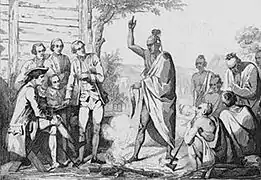
Hearing that a French military force was approaching, the inhabitants had hastily erected a stockade. Céloron described it as a "stone fort, strongly built and in good condition for their defense." He sent a delegation of Kahnawake and Abenaki Indians led by Philippe-Thomas Chabert de Joncaire, but as they approached the town, warriors manning the stockade fired three shots at them, all of which struck the French flag they were carrying. Joncaire boldly continued, and the Shawnees conducted the party to the council house in the center of the town. There, as Joncaire was explaining the purpose of Céloron's expedition, an Indian interrupted him, "saying that the French deceived them and that they came only to destroy them and their families." With that a number of warriors "rushed to arms, saying that these Frenchmen should be killed" and Céloron and the others waiting upriver in the canoes should be ambushed. Fortunately, "an Iroquois chief averted the storm." With his help, the French-Canadian, Joncaire, who was raised in a Seneca community, was released to return under guard to the canoes waiting upstream with Céloron and the rest of the expedition.[4] The others who had accompanied Joncaire were held hostage by the Shawnees.[46]:44–49
Céloron selected a guard of fifty reliable soldiers and went to the riverbank opposite the town. As he approached, the Shawnees saluted him by firing their guns into the air. The town's chiefs and elders crossed the river and came with flags and pipes of peace. They had cut the grass to prepare a meeting place and everyone sat together. The men taken hostage with Joncaire were brought forward and handed over. The Shawnees invited Céloron to enter the town and address them in their council house, but he was wary of being ambushed:
I was aware of the weakness of my detachment; two-thirds were recruits who had never made an attack...[The Indians] being much displeased, it would have been a great imprudence to go to their village.[46]
He instead invited them to visit his encampment to hear an announcement. The next day, a canoe bearing a white flag approached Céloron's camp, and Shawnee and Iroquois leaders from Lower Shawneetown met with Céloron. They apologized for the shots fired at the French delegation, saying that they had feared that the French were planning to attack the town.[33]
Céloron negotiated with the leaders of the town for two days but he was unable to persuade them to abandon their loyalty to the English, as "the cheap merchandise which the English furnished was [a] very seducing motive for them to remain attached to the latter." On 25 August he summoned the five Pennsylvania traders who were then living in the town and ordered them to leave, stating that "they had no right to trade or aught else on the [Ohio] River."[33] Céloron considered plundering their goods, but as he was confronted by a large and well-armed Shawnee force, he desisted and continued on his way.[47] He wrote in his journal:
My instructions enjoin me to summon the English traders in Sinhioto and instruct them to withdraw on pain of what might ensue, and even to pillage the English should their response be antagonistic, but I am not strong enough and as these traders are well-established in a village and well-supported by the Indians, the attempt would have failed and put the French to shame. I have therefore withdrawn.[46][48]
In his description of the meeting between Céloron and the English traders, Bonnecamps says, "The Englishmen...were ordered to withdraw, and promised to do so."[35]
Céloron's expedition was intended to impress the inhabitants of the Ohio River Valley with the capability of the French to maintain control over the region, but it met with defiance and resulted in a weakening of the French position.[32] Nonetheless, he did succeed in expelling English traders from Logstown.
Commerce with English traders
.jpg.webp)
William Trent established a storehouse in Lower Shawneetown in the mid-1730s, and the Shawnees kept it secure in order to encourage further trade with the British. Between 1748 and 1751 the British traders Andrew Montour and George Croghan visited the town three times. In 1749 Croghan built a trading post in Lower Shawneetown (probably outside the town near the main overland trail or the Ohio River bank where traders could beach their canoes), operating in conjunction with his trading posts already established at Pine Creek, Oswegle Bottom, Muskingum, and Pickawillany, dominating the Ohio Valley deerskin trade.[27][49] He may have spent the winter of 1752-1753 in Lower Shawneetown.[7] On August 4, 1752 Trent met there with a group of survivors of the raid on Pickawillany, including the wife and son of Memeskia, the Piankeshaw chief who had been killed in the raid, and presented them with gifts. He engaged in talks with village elders in an attempt to strengthen the alliance between the Shawnees and the British government.[7]:294
Lower Shawneetown's size and connections to neighboring communities allowed traders to establish storehouses for incoming and outgoing goods, managed by European men who lived in the town year-round and sometimes married Native American women. These trading posts attracted local hunters to bring skins and furs to the town, meaning that a post in Lower Shawneetown could do profitable business with dozens of villages without requiring the traders themselves to travel, as they had done previously. The town's location on the Ohio River allowed traders to send furs and skins by canoe up to Logstown, where they were taken by packhorses over the mountains, transferred into wagons for a fourteen-day journey to Philadelphia and then shipped to London.[27]
Visit by Christopher Gist, 1751
In 1750, the Ohio Company hired Christopher Gist, a skilled woodsman and surveyor, to explore the Ohio Valley in order to identify lands for potential settlement, and to undo any French influence lingering after Céloron's expedition. He surveyed the Kanawhan Region and the Ohio Valley tributaries in 1750–1751 and 1753, following the trail of Céloron through the Ohio country, visiting the same Indian towns the French expedition had visited and meeting with chiefs.[4] In 1751 Gist, Croghan and Montour, accompanied by Robert Callender, visited Lower Shawneetown. Gist's journal entry from January, 1751 states:
Tuesday [January] 29 - Set out...to the Mouth of Sciodoe Creek opposite to the Shannoah Town, here we fired our Guns to alarm the Traders, who soon answered, and came and ferryed Us over to the Town — The Land about the Mouth of Sciodoe Creek is rich but broken fine Bottoms upon the River & Creek. The Shannoah Town is situate upon both Sides the River Ohio, just below the Mouth of Sciodoe Creek, and contains about 300 Men, there are about 40 Houses on the S Side of the River and about 100 on the N Side, with a Kind of State-House of about 90 Feet long, with a light Cover of Bark in which they hold their Councils.[34]
The day after they arrived, Gist, Croghan, Callender and Montour met in the council house with the town's elders and a chief whom Gist identifies as Big Hannaona (probably Big Hominy, also known as Meshemethequater). Croghan made a speech in which he informed the chiefs that "the French offered a large sum of Money to any person who would bring them the said Croghan and Andrew Montour the Interpreter alive, or if dead their scalps." This was apparently a further attempt by the French to drive out the English traders, and Croghan evidently felt safe enough in the community to reveal that there was a bounty on his head. He then promised "a large Present of Goods...which was under the Care of the Governor of Virginia, who had sent Me out to invite them to come and see Him, & partake of their Father's Present next Summer." Big Hannaona responded with a warm speech which concluded: "We hope that the Friendship now subsisting between us & our Brothers will last as long as the Sun Shines or the Moon gives light." The journal terminates with a detailed description of a wedding festival Gist witnessed during his 12-day stay in Lower Shawneetown.[34]
Trade goods
Archeological evidence shows that, by the 1750s, trade had transformed the lives of the residents of the town. Traders brought guns, metal tools, knives, saddles, hatchets, glass and ceramic beads, strouds (a kind of coarse blanket), ruffled and plain shirts, coats, clay tobacco pipes, brass and iron pots, and rum to trade for the furs and skins of deer, elk, bison, bear, beaver, raccoon, fox, wildcat, muskrat, mink and fisher. Town residents wore European-style glass beads, silver earrings, armbands, and brooches, rather than traditional Native American beads and pendants made from shell, animal teeth, or animal bone. Cloth matchcoats, wool blankets, linen skirts and shirts and leather shoes supplemented moccasins and garments manufactured from animal skins. Large cast-iron pots began to replace ceramic vessels in the preparation of salt or maple sugar. Strings of glass beads, metal pendants,[27] silver earrings and brooches[20] of European manufacture were buried along with the dead. European trade goods found at the site include gun spalls and gunflints, gun parts (sideplate, mainspring, ram pipes, and breech plugs), wire-wound and drawn glass beads, tinkling cones, a button, a brass pendant, an earring, cutlery, kettle ears, a key, nails, chisels, hooks, a buckle, a Jew's harp, and pieces of a pair of iron scissors.[2][15][20]
In June of 1752 William Trent learned that his storehouse had been plundered during the Raid on Pickawillany and visited the ruined town to recover what remained of his furs, bringing back what survived (valued at £3000) for safekeeping in Lower Shawneetown.[45]:129
1753 floods
The portion of Lower Shawneetown east of the Scioto was destroyed by floods in 1753.[22] George Croghan described the event in a journal entry:
On the Ohio, just below the mouth of the Scioto, on a high bank, near forty feet, formerly stood the Shawnesse Town called the Lower Town, which was all carried away, except three or four houses, by a great flood in the Scioto. I was in the town at the time. Though the banks of the Ohio were so high, the water was nine feet [deep] on the top, which obliged the whole Town to take to their canoes, and move with their effects to the hills. The Shawnesse afterwards built their Town on the opposite side of the River, which, during the [French and Indian War], they abandoned...and removed to the Plains of the Scioto.[7]:155
British traders relocated with the rest of the town's population, intending to maintain their profitable businesses. In the 1918 edition of Narrative of the Life of Mrs. Mary Jemison, George P. Donehoo, Secretary of the Pennsylvania Historical Commission, records:
Shortly after 1753 the village...was destroyed by a flood. The town was then built up on the south side of the Ohio. George Croghan, William Trent and other Indian traders had trading houses at this place. Croghan's large store...was destroyed by the French and Indians in 1754.[37]:339–340
Expulsion of the English traders, 1754
In 1753 Governor Duquesne sent over two thousand French and Canadian troupes de la marine to the south shore of Lake Erie, under the command of Paul Marin de la Malgue,[51] to build a road and construct a series of forts (Fort Presque Isle, Fort Le Boeuf, and Fort Machault).[52] On 1 September, supplies were sent to this force from Fort de Chartres in Illinois, escorted by one hundred infantry under the command of Captain Demazilière and Lieutenant Portneuf.[7]:156 They reached the falls of the Ohio (the site of present-day Louisville, Kentucky) and Lt. Portneuf was sent on ahead with nine men to see if Marin's troops were further upriver. Portneuf traveled for a week before reaching Lower Shawneetown. He observed English traders living in the town, as well as a few deserters from the French army, "some of whom had taken wives there." Portneuf was invited to a conference with a Shawnee chief, who "advised him to leave, adding that their young men were beginning to lose their minds and wanted to kill him." Portneuf and his men left that night and returned to Fort de Chartres.[53][54][55]
In January 1754, a Chickasaw man reported a slightly different version of this event to George Croghan:
...We hear that there is a large body of French at the Falls of the Ohio...[with] abundance of Provisions and Powder and Lead with them...coming up the river to meet the Army from Canada coming down. He says a Canoe with Ten French Men in her came up to the Lower Shawonese Town with him, but on some of the English Traders threatening to take them, they set back that night without telling their business.[56]:75–76
The Shawnees then learned that "several hundreds" of Ottaway warriors "are gathering together on this side Lake Erie...in order to cutt off the Shawonese at the Lower Shawonese Town. The French and Ottaways offered the hatchet (proposed a military alliance) to the Owendats but they refused to join them."[56]
This threat, plus the presence of French troops in the Ohio Valley, persuaded the residents of Lower Shawneetown and several other communities that the balance of power was about to change, and they expelled the English traders in 1754,[27] as much for their safety as to indicate that they were showing no favor towards the English.[57] George Croghan reported that he had lost his storehouses and their contents at Pine Creek, Logstown, Muskingum and the newly-built storehouse he shared with William Trent and Robert Callender:[37] "One large House on the Ohio, opposite to the mouth of the River Scioto, where the Shawanese had built their new Town, called the Lower Shawanese Town, which House we learn by the Indians is now in the possession of a French Trader." Croghan's cornfields, canoes and bateaux[58] were also confiscated and turned over to French traders by the Shawnees.[7]:9–10
Visit by Twightwee leaders, 1754
Following the 1752 raid on Pickawillany and subsequent attacks, the leaders of Lower Shawneetown had refused to join the Twightwee Indians in their fight against the French. Even after the expulsion of the English traders, Lower Shawneetown's chiefs remained stubbornly neutral. In October, 1754 Twightwee leaders visited Lower Shawneetown demanding that Shawnee chiefs support them against the French:
You know that the French have invaded our Country on all Sides; Why do you sit so still? Will you be Slaves to the French, and suffer them to be Masters of all the Land and all the Game? Rise up, take the Hatchet, and follow our Example. We kill'd not long ago, Fifty Frenchmen, all Warriors, in one Day. Five other Nations have join'd us; and if you, and your Grandfathers, the Delaware, will but stir, the French will soon be forced to fly.[57]
Shawnee leaders at Lower Shawneetown replied:
Brethren, the Twightwees, We are surpriz'd at your Request. The Six United Nations have desir'd us to sit still, and not mind the French; and that we must keep our Ears and Eyes towards the Six United Nations; and so do our Grandfathers the Delawares. We desire you would spare us and leave our Town before the French hear of you, and come and kill you here, and plunge us into the War, before the Six United Nations begin it.[57]
Captives
At least nine captives taken during raids on American pioneer settlements are known to have lived in or visited Lower Shawneetown. Catherine Gougar (1732–1801) was kidnapped in 1744 from her home in Berks County, Pennsylvania and lived in the town for five years.[59][60] She was eventually sold to French-Canadian traders and after two more years in Canada, managed to return home in 1751.[61]
Mary Draper Ingles (1732–1815) was kidnapped during the Draper's Meadow massacre in July 1755, along with her two sons, her sister-in-law Bettie Robertson Draper, and her neighbor Henry Lenard (or Leonard),[62][63][64] all of whom were taken to Lower Shawneetown.[45]:20 Mary stayed in the town for about three weeks, during which time her sons were taken from her and adopted by Shawnee families. Mary's sister-in-law Bettie was given to a widowed Cherokee chief.[65] French traders were living in the town at that time, selling cloth, and Mary demonstrated her skill in sewing shirts, for which she was paid "in goods."[66] Mary was eventually taken to Big Bone Lick to make salt by boiling brine. She and another captive escaped in mid-October, 1755, and walked several hundred miles to return home.[64][67] One source states that Mary's neighbor Henry Leonard also escaped.[68]
An article in the New-York Mercury of 16 February 1756, describing Mary's capture and escape mentions that, while in Lower Shawneetown, she saw "a considerable Number of English Prisoners, who have been taken Captives from the Frontiers of Virginia."[69] The same newspaper article states that she saw Captain Samuel Stalnaker (1682-1769), who had been captured during a raid on his homestead on the north fork of the Holston River in Virginia on June 18, 1755.[69] Several sources, including a letter from Governor Robert Dinwiddie dated 21 June 1756, report that he later escaped, although no details are given.[70][71][72][73][74] On his arrival in Williamsburg in June, 1756, Stalnaker reported that he had observed French officers and about a thousand French troupes de la marine and Canadian militia camped outside Lower Shawneetown, on their way to Fort Duquesne, where they would encounter British troops under the command of Major-General Edward Braddock and George Washington at the Battle of the Monongahela on 9 July, 1755.[74][75]
Moses Moore and Isham Bernat were captured in Virginia and taken to Lower Shawneetown in the spring of 1758. Bernat was living at his plantation near the Irwin River when he was taken prisoner by a party of Shawnees, Wyandots, Delawares and Mingoes on 31 March 1758. Moore was hunting beaver in Augusta County when he was taken prisoner by a party of Wyandots in April, 1758. They were held for a few days in Lower Shawneetown before escaping and walking for 23 days to reach Pittsburgh.[26][7]
Destruction and relocation, 1758
John P. Hale states that in about November, 1758,
... a very extreme, if not unprecedented, flood in the rivers swept off a greater part of the town, and it was never rebuilt at that place; but the tribe moved its headquarters ... up the Scioto and built up successively the Old and New Chillicothe, or Che-le-co-the Towns. There remained a Shawnee village at the mouth of the Scioto, which was then built upon the other side, the present site of the city of Portsmouth.[76]
When Mary Jemison, a captive of the Seneca, spent the winter at the mouth of the Scioto River in 1758–1759, Lower Shawneetown had been abandoned and relocated further up the Scioto River.[37]:360–361 This new village was Chalahgawtha at the site of present-day Chillicothe, Ohio.[7]
George P. Donehoo says:
In 1758, the first year of Mary Jemison's going there, the Shawnee moved their town (the Lower Shawnee Town) from the mouth of the Scioto to the upper plains of the Scioto, sending for the Shawnees of Logstown to join them there and possibly also for the Shawnees of the [Upper] Shawnee Town at the mouth of the Great Kanawha to do the same.[37]
Legacy
A. Gwynn Henderson argues that multiethnic "supervillages" such as Lower Shawneetown might be considered early Native American city-states because of their political autonomy and the new opportunities they created for different tribes as well as for the interaction of Native Americans with Europeans:
"The intermarriage and ethnic diversity within these settlements created a multitude of new kinship and social situations, adding layers of ethnic, social, and village relationships. Thus, the potential for factionalism and the development of different European responses may have been even greater in these villages than in traditional single-ethnic villages. As autonomous communities, these republics existed politically beyond the control of the French, British, and even the Six Nations at Onondaga, and their residents were responsible only to themselves. Thus, they had the freedom to make decisions based on their own needs, traditions, and cultural proscriptions, and they could ally themselves with whomever they wished or change their alliances when it suited their needs.[27]
Lower Shawneetown's diversity prevented it from operating as a political entity, however. Independent factions, themselves often divided, responded individually to events, to the frustration of European envoys. Community leaders were rarely able to unify a majority in backing policy decisions, which prevented Europeans from establishing firm diplomatic relations with Lower Shawneetown as they did (to some extent) at Logstown.[27]
Lower Shawneetown Archeological District
The Lower Shawneetown Archeological District, in Greenup County, Kentucky and Lewis County, Kentucky near South Portsmouth, is a 335 acres (1.36 km2) historic district which was listed on the National Register of Historic Places in 1985.[77]
It is Address restricted[78].
It includes the Lower Shawneetown village site, graves/burials, and more in six contributing sites and was listed for its information potential.[1]
Portsmouth floodwall murals
In 1992 muralist Robert Dafford was commissioned to create a series of murals depicting the history of Portsmouth, Ohio, on the floodwall,[79] built in 1937 to protect the city from periodic floods after the Ohio River flood of 1937. Between 1992 and 2003 Dafford created 65 paintings[80] covering Ohio history from the Hopewell mound builders to the present day. The first mural shows how the Hopewell mounds near Portsmouth might have appeared soon after their construction.[81] The second mural depicts Lower Shawneetown as it might have appeared on a winter day in 1730.[82] The third mural shows Pierre-Joseph Céloron de Blainville meeting with Native American residents of Lower Shawneetown and a few British traders during his visit on 25 August, 1749.[83][84][85]
See also
References
- "National Register Information System". National Register of Historic Places. National Park Service. 2010-11-02. Archived from the original on 2013-02-20.
- Sharp, William E. (1996). "Chapter 6: Fort Ancient Farmers". In Lewis, R. Barry (ed.). Kentucky Archaeology. University Press of Kentucky. pp. 170–176. ISBN 0-8131-1907-3.
- Stephen Warren, Worlds the Shawnees Made: Migration and Violence in Early America, UNC Press Books, 2014 ISBN 1469611732
- Phillip R. Shriver, "Lower Shawnee Town on the Eve of the French and Indian War," Ohio Archaeologist, Vol 40:3, Summer 1990, pp 16-21
- Andrew Lee Feight, "Lower Shawnee Town and Celoron's Expedition," Scioto Historical, accessed November 22, 2020
- Robert F. Maslowski, "Appalachian Migrations: Historic and Prehistoric. In Instances of Prehistoric and Historic Archaeology in the Mountainous Areas of the Eastern United States: Papers from Upland Archaeology in the East Symposium XI, Clarence R. Geir, Compiler, pp. 49-63. James Madison University, 2012
- Charles Augustus Hanna, The Wilderness Trail: Or, The Ventures and Adventures of the Pennsylvania Traders on the Allegheny Path, Volumes 1 and 2, Putnam's sons, 1911
- Case, D. Troy and Christopher Carr, eds. The Scioto Hopewell and their Neighbors: Bioarchaeological Documentation and Cultural Understanding. New York, NY: Kluwer Academic/Plenum Publishers, 2008
- Woodward, Susan L., and Jerry N. McDonald. Indian Mounds of the Middle Ohio Valley: A Guide to Mounds and Earthworks of the Adena, Hopewell, Cole, and Fort Ancient People. Lincoln: The University of Nebraska Press, 2002
- Ephraim George Squier; Edwin Hamilton Davis (1848). Ancient Monuments of the Mississippi Valley. Smithsonian Institution. pp. 179–187.
- George Horton and Terry Stocker, "The Woman Who Fell from the Sky and the Portsmouth, Ohio Hopewell Earthworks," Journal of Ohio Archaeology 6:1-15, 2019
- Tom Corrigan, "New archeology study says local mound was huge Native American religious figure," Portsmouth Daily Times, July 2, 2019
- Brad Lepper, "Archaeology: Not enough evidence to say Portsmouth Earthworks show ‘Woman Who Fell from the Sky’," Columbus Dispatch, Nov 3, 2019
- Henderson, A. Gwynn (2008), "Chapter 6:Mississippi Period" (PDF), in David Pollack (ed.), The Archaeology of Kentucky:An update, Kentucky Heritage Council, pp. 830–832, retrieved 2020-11-23
- David Pollack and A. Gwynn Henderson, "A Preliminary Report on the Contact Period Occupation at Lower Shawneetown (l5GP15), Greenup County, Kentucky," paper presented at the 58th Annual Meeting of the Central States Anthropological Society on April 9, 1982.
- Lee H. Hanson, The Hardin Village Site, University of Kentucky Press, 1966 ISBN 0598262113
- Michelle M. Davidson, "Preliminary mineralogical and chemical study of Pre-Madisonville and Madisonville horizon Fort Ancient ceramics," Norse Scientist, Vol. 1, Issue 1, April 2003; Northern Kentucky University.
- A. Gwynn Henderson, David Pollack, "A Native History of Kentucky: Selections from Chapter 17: Kentucky," in Native America: A State-by-State Historical Encyclopedia, edited by Daniel S. Murphree, Volume 1, pages 393-440; Greenwood Press, Santa Barbara, CA. 2012
- Dubin, Lois Sherr (1999). North American Indian Jewelry and Adornment: From Prehistory to the Present. New York: Harry N. Abrams. ISBN 978-0-8109-3689-8.
- A. Gwynn Henderson, "Dispelling the Myth: Seventeenth- and Eighteenth-Century Indian Life in Kentucky," The Register of the Kentucky Historical Society, Vol. 90, No. 1, The KentuckyImage (Bicentennial Issue), pp. 1-25, Kentucky Historical Society
- Ian W. Brown, Salt and the Eastern North American Indian: An Archaeological Study, Cambridge, Mass., 1980.
- Andrew Lee Feight, "Lower Shawnee Town and the Flood of 1753," Lower Scioto Blog , posted on December 24, 2007
- Caudill, Courtney B., ""Mischiefs So Close to Each Other": External Relations of the Ohio Valley Shawnees, 1730-1775." Dissertations, Theses, and Masters Projects. Paper 1539625770, May 1992
- O'Donnell, James H. Ohio's First Peoples, p. 31. Athens, Ohio: Ohio University Press, 2004. ISBN 0-8214-1525-5 (paperback), ISBN 0-8214-1524-7 (hardcover)
- Foster, Emily (2000-08-24). The Ohio Frontier: An Anthology of Early Writings. The University Press of Kentucky. p. 13. ISBN 978-0-8131-0979-4.
- Samuel Hazard, ed. Pennsylvania Archives: 1st Series: Selected and Arranged from Original Documents in the Office of the Secretary of the Commonwealth, Conformably to Acts of the General Assembly, February 15, 1851, and March 1, 1852. Pennsylvania, Secretary of the Commonwealth. J. Severns, 1853; pp. 632-33.
- A. Gwynn Henderson, "The Lower Shawnee Town on Ohio: Sustaining Native Autonomy in an Indian "Republic"." In Craig Thompson Friend, ed., The Buzzel about Kentuck: Settling the Promised Land, University Press of Kentucky, 1999; pp. 25-56. ISBN 0813133394
- O. H. Marshall, "De Celoron's Expedition to the Ohio in 1749, Magazine of American History, March, 1878, p. 146.
- Ermine Wheeler Voegelin, An Ethnohistorical Report on the Indian Use and Occupancy of Royce Area 11, Ohio and Indiana, 2 vols. (New York: Garland Press, 1974), vol 1, p. 261.
- Jerry E. Clark, "A System Model of Shawnee Indian Migration," Transactions of the Nebraska Academy of Sciences, Vol VII, 1979.
- Gordon Calloway, The Shawnees and the War for America, The Penguin library of American Indian history; Penguin, 2007. ISBN 0670038628
- Richard White, The Middle Ground: Indians, Empires, and Republics in the Great Lakes Region, 1650–1815 Cambridge studies in North American Indian history, Cambridge University Press, 1991. ISBN 1139495682
- "Celeron de Bienville". Ohio History Central. Ohio Historical Society. Retrieved 2019-05-13.
- The Journal of Christopher Gist, 1750–1751 From Lewis P. Summers, 1929, Annals of Southwest Virginia, 1769–1800. Abingdon, VA.
- "Relation du voyage de la Belle Rivière faite en 1749, sous les ordres de M. de Céloron," in Reuben Gold Thwaites, ed., The Jesuit Relations and Allied Documents, 73 vols. Cleveland: Burrow Brothers, 1896-1901, vol. 69; pp. 181-83.
- Henry F. Dobyns, William R. Swagerty, Their Number Become Thinned: Native American Population Dynamics in Eastern North America, ACLS Humanities E-Book; Native American historic demography series; Newberry Library. Center for the History of the American Indian, University of Tennessee Press, 1983. ISBN 0870494007
- James Everett Seaver, Charles Delamater Vail A Narrative of the Life of Mary Jemison: The White Woman of the Genesee, American Scenic and Historic Preservation Society, 1918.
- David Osborne, Raisin' Cane in Appalachia, Trafford Publishing ISBN 1466988339
- Andrew Lee Feight, "Raven Rock State Nature Preserve," Scioto Historical, accessed 26 Nov 2020
- "Anonymous Diary of a Trip from Detroit to the Ohio River, May 22 - August 24, 1745," in PAPIERS CONTRECOEUR Le Conflit Angelo - Francias Sur L' Ohio De 1745 a 1756. English translation of documents in the Quebec Seminary by Donald Kent, 1952
- Guy Lanoue, "Female Rituals of the Iroquois," Université de Montréal.
- Lucien Beckner, "Eskippakithiki, The Last Indian Town in Kentucky," The Filson Club History Quarterly, Vol. 6, No. 4, Oct 1932. Louisville, KY, pp 355-382
- The Expedition of Baron De Longueuil, 1739-1740, translated by Donald H. Kent, Sylvester Stevens, ed., 1953. Pennsylvania Historical and Museum Commission
- Watkins et al., Michigan historical collections, vols. 1-39, by Michigan Historical Commission, Michigan State Historical Society, Pioneer Society of the State of Michigan, Pioneer and Historical Society of the State of Michigan, Michigan Pioneer and Historical Society, Michigan State Historical Society. Lansing, 1876
- Thwaites, Reuben Gold. The French Regime in Wisconsin and the Northwest, Vol I 1634-1760. State Historical Society of Wisconsin, 1908
- Orsamus Holmes Marshall, Andrew Arnold Lambing, Expedition of Celoron to the Ohio Country in 1749, F.J. Heer Printing Company, 1921
- Ian K. Steele, Setting All the Captives Free: Capture, Adjustment, and Recollection in Allegheny Country, Vol. 71 of McGill-Queen's Native and Northern Series; McGill-Queen's Press - MQUP, 2013. ISBN 0773589899
- Allan W. Eckert, That Dark and Bloody River: Chronicles of the Ohio River Valley, Random House 1995, 2011 ISBN 0307790460
- Volwiler, Albert T. George Croghan and the Westward Movement, 1741–1782. Cleveland: The Arthur H. Clark Company, 1926
- Annosanah: A Novel Based on the Life of Christopher Gist
- "Paul Marin de La Malgue," Dictionary of Canadian Biography
- Kathleen Lugarich, "Constructing the French Forts of the Ohio Country," Fort Pitt Museum, October 9, 2015
- Le Chevalier de Kerlérec, The Last Years of French Louisiana, translated by Marc de Villiers du Terrage, Carl A. Brasseaux; University of Southwestern Louisiana. Center for Louisiana Studies, 1982
- Le Chevalier de Kerlérec, Les dernières années de la Louisiane française, Librairie Orientale & Américaine E. Guilmoto, 1905
- Kerlérec, Louis Billouart, l'Affaire de la Louisiane: un déni de justice sous le règne de Louis XV: essai de réhabilitation de Louis Billouart de Kervaségan, chevalier de Kerlérec, gentilhomme breton, capitaine des vaisseaux du roy, brigadier des armées du roy, dernier gouverneur français de la Louisiane. France: Portes du large, 2003.
- Thwaites, Reuben Gold, Early Western Travels, 1748-1846: Journals of Conrad Weiser (1748), George Croghan (1750-1765), Christian Frederick Post (1758), and Thomas Morris (1764). Vol. 2. Clark, 1904.
- Colonial records of Pennsylvania: Minutes of the Provincial Council of Pennsylvania from the organization to the termination of the proprietary government, Vol. 6. April 1754 - January 1756. Theo. Fenn, Harrisburg 1851.
- William McCullough Darlington, Christopher Gist's Journals: With Historical, Geographical and Ethnological Notes and Biographies of His Contemporaries by William M. Darlington. J. R. Weldin & Company, 1893.
- Caroline S. Coldren, "Catherine Gougar Goodman," monograph, April 1940; Family History Library.
- Catherine Gougar Goodman
- Frank Warner, "Catherine Gougar," Ohio History, Volume 31; Ohio Historical Society., 1922.
- Brown, Ellen Apperson. "What Really Happened at Drapers Meadows? The Evolution of a Frontier Legend" (PDF). Virginia History Exchange.
- Cummings, Kathy. "Walking in Their Footsteps: The Journey of Mary Ingles". Pioneer Times.
- Jennings, Gary (August 1968). "An Indian Captivity". American Heritage Magazine. 19 (5).
- Addington, Luther F. (1967). "Captivity of Mary Draper Ingles". Historical "Sketches of Southwest Virginia. Southwest Virginia Historical Society. Publication No 2.
- Ingles, John (1824). The Narrative of Col. John Ingles Relating to Mary Ingles and the Escape from Big Bone Lick (PDF). Archived from the original (PDF) on 2012-03-13. Retrieved 2019-05-10.
- "James Duvall, "Mary Ingles and the Escape from Big Bone Lick," Boone County Public Library, 2009" (PDF). Archived from the original (PDF) on 2012-03-13. Retrieved 2014-04-21.
- Lyman Chalkley, Chronicles of the Scotch-Irish Settlement in Virginia: Extracted from the Original Court Records of Augusta County, 1745-1800, Volume 2. Augusta County (Va.): The Commonwealth Printing Company, 2010; p. 510.
- Contemporary newspaper account of Mary Ingles' escape in the New York Mercury, 26 January 1756, p. 3, col. 1; in Early Documents Relating to Mary Ingles and the Escape from Big Bone Lick, transcribed by James Duvall, Boone County Public Library, Burlington, KY 2008
- Robert A. Brock, ed. The official records of Robert Dinwiddie, Lieutenant-governor of the Colony of Virginia, 1751-1758, Richmond: The Society, 1883-84; p. 447.
- Lewis Preston Summers, History of Southwest Virginia, 1746-1786, Washington County, 1777-1870, J.L. Hill Print. Company, 1903.
- Indian Attacks of 1755-1758 in Augusta County, VA
- Pendleton, William Cecil. History of Tazewell County and Southwest Virginia: 1748-1920. W. C. Hill printing Company, Richmond, 1920; p. 175
- "Captain Samuel Stalnaker, Colonial Soldier and Early Pioneer," excerpted from Leo Stalnaker, Captain Samuel Stalnaker, Colonial Soldier and Early Pioneer and Some of His Descendents, 1938.
- The Dinwiddie Papers: The Official Records of Robert Dinwiddie. N.p.: Virginia Historical Society, 1933.
- John P. Hale, Trans-Allegheny pioneers : historical sketches of the first white settlements west of the Alleghenies, Cincinnati: The Graphic Press, 1886.
- "National Register of Historic Places Inventory/Nomination: Lower Shawneetown Archeological District". National Park Service. With accompanying pictures
- Federal and state laws and practices restrict general public access to information regarding the specific location of this resource. In some cases, this is to protect archeological sites from vandalism, while in other cases it is restricted at the request of the owner. See: Knoerl, John; Miller, Diane; Shrimpton, Rebecca H. (1990), Guidelines for Restricting Information about Historic and Prehistoric Resources, National Register Bulletin, National Park Service, U.S. Department of the Interior, OCLC 20706997.
- Frances Killea, "Floodwall Murals, Portsmouth," Ohio Magazine, July 2018, www.ohiomagazine.com
- Michael Harding, "Snapshots: The Portsmouth Flood Wall Murals," July 31, 2018
- William Fischer, Jr., "The Mound Builders Mural," Taken: September 2, 2012
- William Fischer, Jr., "Early Shawnee Village, 1730," Taken: September 2, 2012
- William Fischer, Jr., "Céloron de Blainville," Taken: September 2, 2012
- Portsmouth Ohio Murals
- William Fischer, Jr., "Scioto County, Experience Our Heritage," September 10, 2012
| Anderson Focus |
|  |
|---|---|---|
| Baum Focus |
| |
| Feurt Focus | ||
| Madisonville Focus | ||
| ||
| Topics | |
|---|---|
| Lists by state |
|
| Lists by insular areas | |
| Lists by associated state | |
| Other areas | |
| Related | |
| |