National Register of Historic Places listings in Putnam County, Florida
This is a list of the National Register of Historic Places listings in Putnam County, Florida.
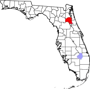
Location of Putnam County in Florida
This is intended to be a complete list of the properties and districts on the National Register of Historic Places in Putnam County, Florida, United States. The locations of National Register properties and districts for which the latitude and longitude coordinates are included below may be seen in a map.[1]
There are 19 properties and districts listed on the National Register in the county.
- This National Park Service list is complete through NPS recent listings posted February 5, 2021.[2]
| Alachua - Baker - Bay - Bradford - Brevard - Broward - Calhoun - Charlotte - Citrus - Clay - Collier - Columbia - DeSoto - Dixie - Duval - Escambia - Flagler - Franklin - Gadsden - Gilchrist - Glades - Gulf - Hamilton - Hardee - Hendry - Hernando - Highlands - Hillsborough (Tampa) - Holmes - Indian River - Jackson - Jefferson - Lafayette - Lake - Lee - Leon - Levy - Liberty - Madison - Manatee - Marion - Martin - Miami-Dade (Miami) - Monroe - Nassau - Okaloosa - Okeechobee - Orange - Osceola - Palm Beach - Pasco - Pinellas - Polk - Putnam - St. Johns - St. Lucie - Santa Rosa - Sarasota - Seminole - Sumter - Suwannee - Taylor - Union - Volusia - Wakulla - Walton - Washington |
Current listings
| [3] | Name on the Register[4] | Image | Date listed[5] | Location | City or town | Description |
|---|---|---|---|---|---|---|
| 1 | Bethel African American Episcopal Church |  Bethel African American Episcopal Church |
May 16, 2016 (#16000270) |
719 Reid St. 29°38′53″N 81°38′11″W |
Palatka | |
| 2 | Bostwick School |  Bostwick School |
September 29, 1999 (#99001204) |
125 Tillman Street 29°46′16″N 81°38′02″W |
Bostwick | |
| 3 | Bronson-Mulholland House | 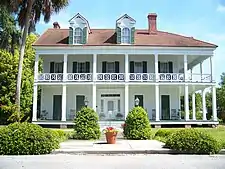 Bronson-Mulholland House |
December 27, 1972 (#72000351) |
Madison between 1st and 2nd Streets 29°39′00″N 81°37′42″W |
Palatka | |
| 4 | Central Academy | 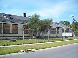 Central Academy |
November 12, 1998 (#98001348) |
1207 Washington Street 29°39′19″N 81°38′26″W |
Palatka | |
| 5 | Crescent City Historic District |  Crescent City Historic District |
December 5, 1996 (#96001367) |
Roughly bounded by Lake Stella, Vernon Avenue, Lake Crescent, and Orange Avenue 29°25′49″N 81°30′36″W |
Crescent City | |
| 6 | Cummings House | March 17, 2015 (#15000075) |
298 County Road 310 29°32′32″N 81°46′28″W |
Palatka | ||
| 7 | Hotel James |  Hotel James |
August 28, 2019 (#100004351) |
300 St. Johns Ave. 29°38′49″N 81°37′52″W |
Palatka | |
| 8 | Hubbard House | 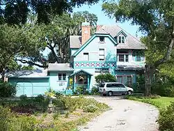 Hubbard House |
August 14, 1973 (#73000601) |
600 North Park Street in Hubbard Park 29°26′02″N 81°30′22″W |
Crescent City | |
| 9 | Interlachen Hall |  Interlachen Hall |
June 2, 2000 (#00000561) |
215 Atlantic Avenue 29°37′24″N 81°53′32″W |
Interlachen | |
| 10 | Larimer Memorial Library | 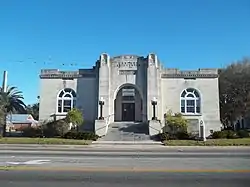 Larimer Memorial Library |
March 12, 2008 (#08000163) |
216 Reid Street 29°38′51″N 81°37′50″W |
Palatka | |
| 11 | Melrose Historic District |  Melrose Historic District |
January 12, 1990 (#89002305) |
Roughly bounded by Seminole Ridge Road, Grove Street, South Street, Quail Street, and Melrose Bay 29°42′45″N 82°03′03″W |
Melrose | |
| 12 | Melrose Woman's Club |  Melrose Woman's Club |
April 6, 1978 (#78000956) |
Pine Street 29°42′40″N 82°02′49″W |
Melrose | |
| 13 | Mount Royal |  Mount Royal |
May 7, 1973 (#73000603) |
Address Restricted 29°26′11″N 81°39′37″W |
Welaka | |
| 14 | Old A.C.L. Union Depot | 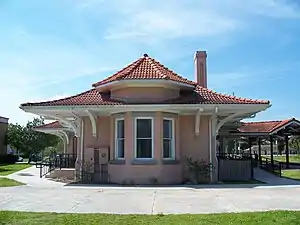 Old A.C.L. Union Depot |
February 25, 1988 (#88000162) |
200 North Twelfth Street 29°38′58″N 81°38′26″W |
Palatka | |
| 15 | Palatka North Historic District | 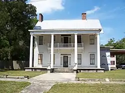 Palatka North Historic District |
November 17, 1983 (#83003552) |
Roughly bounded by the St. Johns River and Bronson, North 1st, North 5th, and Main Streets 29°38′59″N 81°37′47″W |
Palatka | |
| 16 | Palatka Ravine Gardens Historic District |  Palatka Ravine Gardens Historic District |
June 10, 1999 (#99000694) |
1600 Twigg Street 29°38′00″N 81°38′48″W |
Palatka | |
| 17 | Palatka South Historic District |  Palatka South Historic District |
November 17, 1983 (#83003553) |
Roughly bounded by the St. Johns River and Oak, South 9th, and Morris Streets 29°38′40″N 81°38′06″W |
Palatka | |
| 18 | St. Marks Episcopal Church |  St. Marks Episcopal Church |
May 9, 1973 (#73000602) |
2nd and Main Streets 29°38′55″N 81°37′46″W |
Palatka | |
| 19 | Tenney House and Groveland Hotel |  Tenney House and Groveland Hotel |
October 30, 1997 (#97001284) |
100 and 102 Commercial Avenue 29°44′48″N 81°32′50″W |
Federal Point |
See also
| Wikimedia Commons has media related to National Register of Historic Places in Putnam County, Florida. |
References
- The latitude and longitude information provided in this table was derived originally from the National Register Information System, which has been found to be fairly accurate for about 99% of listings. Some locations in this table may have been corrected to current GPS standards.
- "National Register of Historic Places: Weekly List Actions". National Park Service, United States Department of the Interior. Retrieved on February 5, 2021.
- Numbers represent an alphabetical ordering by significant words. Various colorings, defined here, differentiate National Historic Landmarks and historic districts from other NRHP buildings, structures, sites or objects.
- "National Register Information System". National Register of Historic Places. National Park Service. March 13, 2009.
- The eight-digit number below each date is the number assigned to each location in the National Register Information System database, which can be viewed by clicking the number.
Municipalities and communities of Putnam County, Florida, United States | ||
|---|---|---|
| Cities | | |
| Towns | ||
| CDP | ||
| Unincorporated communities |
| |
| Footnotes | ‡This populated place also has portions in an adjacent county or counties | |
| ||
This article is issued from Wikipedia. The text is licensed under Creative Commons - Attribution - Sharealike. Additional terms may apply for the media files.