National Register of Historic Places listings in Manatee County, Florida
This is a list of the National Register of Historic Places listings in Manatee County, Florida.
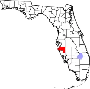
Location of Manatee County in Florida
This is intended to be a complete list of the properties and districts on the National Register of Historic Places in Manatee County, Florida, United States. The locations of National Register properties and districts for which the latitude and longitude coordinates are included below, may be seen in a map.[1]
There are 33 properties and districts listed on the National Register in the county.
- This National Park Service list is complete through NPS recent listings posted January 29, 2021.[2]
| Alachua - Baker - Bay - Bradford - Brevard - Broward - Calhoun - Charlotte - Citrus - Clay - Collier - Columbia - DeSoto - Dixie - Duval - Escambia - Flagler - Franklin - Gadsden - Gilchrist - Glades - Gulf - Hamilton - Hardee - Hendry - Hernando - Highlands - Hillsborough (Tampa) - Holmes - Indian River - Jackson - Jefferson - Lafayette - Lake - Lee - Leon - Levy - Liberty - Madison - Manatee - Marion - Martin - Miami-Dade (Miami) - Monroe - Nassau - Okaloosa - Okeechobee - Orange - Osceola - Palm Beach - Pasco - Pinellas - Polk - Putnam - St. Johns - St. Lucie - Santa Rosa - Sarasota - Seminole - Sumter - Suwannee - Taylor - Union - Volusia - Wakulla - Walton - Washington |
Current listings
KEY
| W | covered in the "Whitfield Estates Subdivision MPS" |
|---|---|
| NRHP-listed | |
| ∞ | NRHP-listed Historic district |
| [3] | Name on the Register[4] | Image | Date listed[5] | Location | City or town | Description |
|---|---|---|---|---|---|---|
| 1 | Austin HouseW |  Austin House |
February 5, 1998 (#98000062) |
227 Delmar Avenue 27°24′16″N 82°34′14″W |
Sarasota | Part of the Whitfield Estates Subdivision MPS |
| 2 | John M. Beasley HouseW | 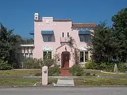 John M. Beasley House |
September 23, 1996[6] (#96000358) |
7706 Westmoreland Drive 27°24′12″N 82°34′16″W |
Sarasota | Part of the Whitfield Estates Subdivision MPS |
| 3 | Braden Castle Park Historic District |  Braden Castle Park Historic District |
May 9, 1983 (#83001428) |
Roughly bounded by the Manatee and Braden Rivers, Ponce DeLeon Street, and Pelot Avenue 27°29′56″N 82°31′49″W |
Bradenton | |
| 4 | Bradenton Carnegie Library | 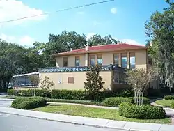 Bradenton Carnegie Library |
April 9, 1987 (#87000616) |
1405 Fourth Avenue, W. 27°29′46″N 82°34′33″W |
Bradenton | |
| 5 | Bradenton Woman's Club |  Bradenton Woman's Club |
February 4, 2019 (#100003409) |
1705 Manatee Ave. W 27°29′44″N 82°34′43″W |
Bradenton | |
| 6 | Cortez Historic District |  Cortez Historic District |
March 16, 1995 (#95000250) |
Bounded by Cortez Road, 119th Street, W., Sarasota Bay, and 124th Street Court, W. 27°28′03″N 82°41′02″W |
Cortez | |
| 7 | Curry Houses Historic District |  Curry Houses Historic District |
September 8, 2015 (#15000571) |
4th Ave. E. between 12th & 14th Sts. E. 27°29′47″N 82°33′00″W |
Bradenton | |
| 8 | De Soto National Memorial | 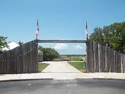 De Soto National Memorial |
October 15, 1966 (#66000078) |
5 miles (8.0 km) west of Bradenton 27°31′25″N 82°38′35″W |
Bradenton | Operated by the National Park Service, the site commemorates the landing in 1539 of Spaniard Hernando de Soto's expeditionary force in the Tampa Bay vicinity, at the start of the first major European exploratory venture in what is now the Southeastern United States. |
| 9 | Duette School | 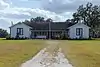 Duette School |
July 30, 2018 (#100002726) |
40755 FL 62 27°35′21″N 82°07′25″W |
Parrish vicinity | |
| 10 | Robert Gamble House | 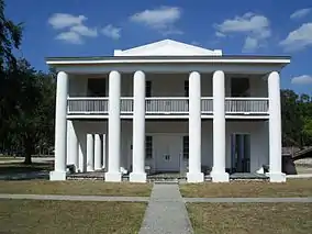 Robert Gamble House |
August 12, 1970 (#70000189) |
On U.S. Route 301 27°31′21″N 82°31′36″W |
Ellenton | Greek Revival vernacular style, known as the Gamble Mansion, built of tabby concrete circa 1850, on a sugar cane plantation close to the Manatee River. Preserved since the 1920s, it is open to the public as an Historic State Park. Unusual feature is an in-ground, covered cistern; there are ruins of a large brick sugarmill a half-mile to the north. The home is of historic interest as a place of refuge for Confederate cabinet official Judah P. Benjamin, who escaped the U.S. from here after the C.S.A. was defeated in 1865. Also on the property is the c1872 Patten House. |
| 11 | Johnson Helm House | 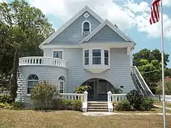 Johnson Helm House |
September 2, 2009 (#09000671) |
2104 53rd Avenue, East, SR 70 27°26′51″N 82°32′17″W |
Oneco | |
| 12 | Rufus P. Jordan House | 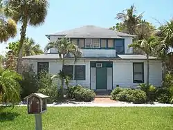 Rufus P. Jordan House |
August 12, 2005 (#05000844) |
760 Broadway Street 27°26′16″N 82°40′55″W |
Longboat Key | |
| 13 | Kreissle Forge |  Kreissle Forge |
December 2, 1996 (#96001370) |
7947 Tamiami Trail 27°24′02″N 82°33′54″W |
Sarasota | |
| 14 | Madira Bickel Mounds |  Madira Bickel Mounds |
August 12, 1970 (#70000190) |
Address Restricted 27°33′55″N 82°35′34″W |
Terra Ceia | Native American ceremonial mound revealing three periods of occupation beginning 2,000 years ago. Now a state archaeological site.[7] |
| 15 | Manatee County Courthouse |  Manatee County Courthouse |
June 11, 1998 (#98000676) |
1115 Manatee Avenue West 27°29′39″N 82°34′23″W |
Bradenton | |
| 16 | Old Manatee County Courthouse | 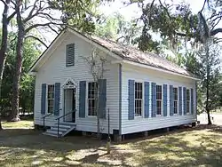 Old Manatee County Courthouse |
June 29, 1976 (#76000601) |
Manatee Avenue and 15th Street, East 27°29′39″N 82°32′52″W |
Bradenton | |
| 17 | Midway Subdivision Historic District |  Midway Subdivision Historic District |
May 29, 1998 (#98000587) |
7201 15th Street, E. 27°24′39″N 82°32′45″W |
Sarasota | |
| 18 | Palmetto Armory | 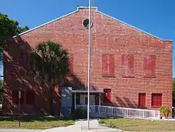 Palmetto Armory |
October 17, 2012 (#12000865) |
810 6th St., W. 27°31′00″N 82°34′27″W |
Palmetto | |
| 19 | Palmetto Historic District |  Palmetto Historic District |
November 6, 1986 (#86003166) |
Roughly bounded by Twenty-first Avenue, Seventh Street, Fifth Avenue, and the Manatee River 27°30′53″N 82°34′41″W |
Palmetto | |
| 20 | Portavant Mound Site | 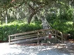 Portavant Mound Site |
December 23, 1994 (#94001475) |
Address Restricted 27°31′52″N 82°37′36″W |
Palmetto | 1200-year-old Native American temple mound—the largest in southwest Florida—and midden complex. Now part of a county park.[8] |
| 21 | Egbert Reasoner House |  Egbert Reasoner House |
May 4, 1995 (#95000555) |
3004 53rd Avenue East 27°26′48″N 82°31′34″W |
Oneco | Demolished[9] |
| 22 | Regina Shipwreck Site |  Regina Shipwreck Site |
December 6, 2005 (#05001355) |
Offshore of Bradenton Beach 27°28′15″N 82°42′10″W |
Bradenton Beach | |
| 23 | Reid-Woods HouseW |  Reid-Woods House |
August 31, 2000 (#00001033) |
373 Whitfield Avenue, Whitfield Estates 27°24′45″N 82°34′06″W |
Sarasota | Part of the Whitfield Estates Subdivision MPS |
| 24 | Richardson House | 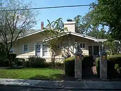 Richardson House |
January 8, 2003 (#02001676) |
1603 1st Avenue, W. 27°29′54″N 82°34′42″W |
Bradenton | |
| 25 | Seagate | 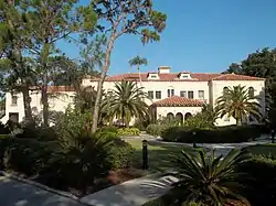 Seagate |
January 21, 1983 (#83001429) |
6565 North Tamiami Trail 27°23′29″N 82°33′52″W |
Sarasota | |
| 26 | Shaw's Point Archeological District | Shaw's Point Archeological District |
April 6, 2001 (#01000342) |
Address Restricted |
Bradenton | |
| 27 | Paul M. Souder HouseW |  Paul M. Souder House |
November 2, 2000 (#00001282) |
242 Greenwood Avenue 27°24′18″N 82°34′11″W |
Sarasota | Part of the Whitfield Estates Subdivision MPS |
| 28 | Stevens-Gilchrist HouseW | 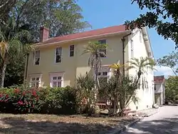 Stevens-Gilchrist House |
August 17, 2001 (#01000887) |
235 Delmar Avenue 27°24′13″N 82°34′13″W |
Sarasota | Part of the Whitfield Estates Subdivision MPS |
| 29 | Terra Ceia Village Improvement Association Hall |  Terra Ceia Village Improvement Association Hall |
September 16, 2003 (#03000942) |
1505 Center Road 27°34′22″N 82°34′54″W |
Terra Ceia | Part of the Clubhouses of Florida's Woman's Clubs MPS |
| 30 | Villa Serena ApartmentsW |  Villa Serena Apartments |
September 29, 2000 (#00001172) |
7014 Willow Street 27°24′55″N 82°34′07″W |
Sarasota | Part of the Whitfield Estates Subdivision MPS |
| 31 | Whitfield Estates-Lantana Avenue Historic DistrictW | 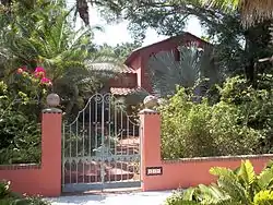 Whitfield Estates-Lantana Avenue Historic District |
March 8, 1997 (#97000209) |
332-336 Lantana Avenue 27°24′47″N 82°34′10″W |
Sarasota | Part of the Whitfield Estates Subdivision MPS |
| 32 | Whitfield Estates-Broughton Street Historic DistrictW | 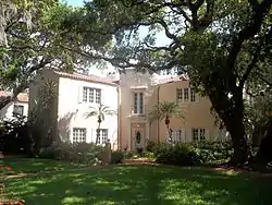 Whitfield Estates-Broughton Street Historic District |
October 29, 1993 (#93001159) |
7207, 7211, 7215, 7219, and 7316 Broughton Street 27°24′18″N 82°34′12″W |
Sarasota | |
| 33 | Woman's Club of Palmetto |  Woman's Club of Palmetto |
March 6, 1986 (#86000380) |
910 Sixth Street, W. 27°30′59″N 82°34′29″W |
Palmetto |
See also
References
- The latitude and longitude information provided in this table was derived originally from the National Register Information System, which has been found to be fairly accurate for about 99% of listings. Some locations in this table may have been corrected to current GPS standards.
- "National Register of Historic Places: Weekly List Actions". National Park Service, United States Department of the Interior. Retrieved on January 29, 2021.
- Numbers represent an alphabetical ordering by significant words. Various colorings, defined here, differentiate National Historic Landmarks and historic districts from other NRHP buildings, structures, sites or objects.
- "National Register Information System". National Register of Historic Places. National Park Service. March 13, 2009.
- The eight-digit number below each date is the number assigned to each location in the National Register Information System database, which can be viewed by clicking the number.
- National Park Service (October 4, 1996), Weekly List of Actions Taken on Properties: 9/23/96 through 9/27/96, archived from the original on May 26, 2017, retrieved August 10, 2018.
- "Madira Bickel Mound State Archaeological Site". Florida State Parks. Retrieved 2013-03-23.
- "Emerson Point Preserve" (PDF). Manatee County Government, Natural Resources Department. Retrieved 2013-03-23.
- "Beth Salem: End of an Oneco landmark". galleries.realestate.heraldtribune.com.
External links
| Wikimedia Commons has media related to National Register of Historic Places in Manatee County, Florida. |
Municipalities and communities of Manatee County, Florida, United States | ||
|---|---|---|
| Cities | | |
| Town | ||
| CDPs | ||
| Unincorporated communities | ||
| Ghost towns | ||
| Footnotes | ‡This populated place also has portions in an adjacent county or counties | |
| ||
This article is issued from Wikipedia. The text is licensed under Creative Commons - Attribution - Sharealike. Additional terms may apply for the media files.