National Register of Historic Places listings in Charlotte County, Florida
This is a list of the National Register of Historic Places listings in Charlotte County, Florida.
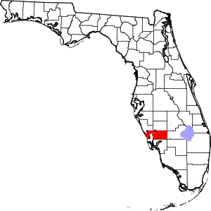
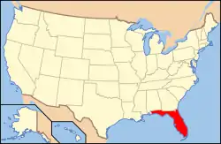
Location of Charlotte County in Florida
This is intended to be a complete list of the properties and districts on the National Register of Historic Places in Charlotte County, Florida, United States. The locations of National Register properties and districts for which the latitude and longitude coordinates are included below, may be seen in a map.[1]
There are 17 properties and districts listed on the National Register in the county.
- This National Park Service list is complete through NPS recent listings posted February 5, 2021.[2]
| Alachua - Baker - Bay - Bradford - Brevard - Broward - Calhoun - Charlotte - Citrus - Clay - Collier - Columbia - DeSoto - Dixie - Duval - Escambia - Flagler - Franklin - Gadsden - Gilchrist - Glades - Gulf - Hamilton - Hardee - Hendry - Hernando - Highlands - Hillsborough (Tampa) - Holmes - Indian River - Jackson - Jefferson - Lafayette - Lake - Lee - Leon - Levy - Liberty - Madison - Manatee - Marion - Martin - Miami-Dade (Miami) - Monroe - Nassau - Okaloosa - Okeechobee - Orange - Osceola - Palm Beach - Pasco - Pinellas - Polk - Putnam - St. Johns - St. Lucie - Santa Rosa - Sarasota - Seminole - Sumter - Suwannee - Taylor - Union - Volusia - Wakulla - Walton - Washington |
Current listings
| [3] | Name on the Register[4] | Image | Date listed[5] | Location | City or town | Description |
|---|---|---|---|---|---|---|
| 1 | Clarence L. Babcock House | 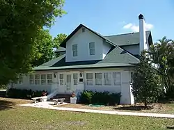 Clarence L. Babcock House |
February 25, 2009 (#09000053) |
25537 Shore Drive 26°56′56″N 82°01′35″W |
Punta Gorda | |
| 2 | Big Mound Key-Boggess Ridge Archeological District | December 3, 1990 (#90001764) |
Address Restricted |
Placida | ||
| 3 | Charlotte High School | .JPG.webp) Charlotte High School |
December 12, 1990 (#90001796) |
1250 Cooper Street 26°55′36″N 82°02′21″W |
Punta Gorda | Part of the Punta Gorda MPS |
| 4 | El Jobean Hotel |  El Jobean Hotel |
September 29, 1999 (#99001203) |
4381 Garden Road 26°57′50″N 82°12′46″W |
El Jobean | |
| 5 | El Jobean Post Office and General Store | 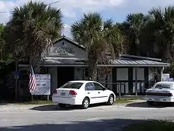 El Jobean Post Office and General Store |
August 27, 1999 (#99001028) |
4370 Garden Road 26°57′51″N 82°12′43″W |
El Jobean | |
| 6 | A. C. Freeman House | 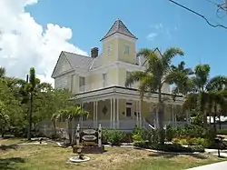 A. C. Freeman House |
January 7, 1987 (#86003648) |
639 East Hargreaves Avenue 26°56′18″N 82°02′27″W |
Punta Gorda | |
| 7 | Icing Station at Bull Bay | April 11, 1991 (#91000399) |
Off Bull Key in Bull Bay 26°46′20″N 82°12′18″W |
Placida | Part of the Fish Cabins of Charlotte Harbor MPS | |
| 8 | Mott Willis Store |  Mott Willis Store |
May 30, 1997 (#97000434) |
22960 Bayshore Road 26°57′29″N 82°04′31″W |
Charlotte Harbor | Demolished in 1998[6] |
| 9 | Old First National Bank of Punta Gorda | 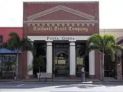 Old First National Bank of Punta Gorda |
March 14, 1991 (#91000280) |
133 West Marion Avenue 26°56′06″N 82°03′02″W |
Punta Gorda | Part of the Punta Gorda MPS |
| 10 | Punta Gorda Atlantic Coast Line Depot |  Punta Gorda Atlantic Coast Line Depot |
December 12, 1990 (#90001797) |
1009 Taylor Road 26°55′44″N 82°02′46″W |
Punta Gorda | Part of the Punta Gorda MPS |
| 11 | Punta Gorda Ice Plant |  Punta Gorda Ice Plant |
December 12, 1990 (#90001798) |
408 Tamiami Trail 26°55′57″N 82°02′50″W |
Punta Gorda | Part of the Punta Gorda MPS |
| 12 | Punta Gorda Residential District | 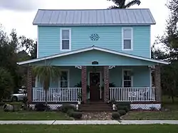 Punta Gorda Residential District |
January 7, 1991 (#90002103) |
Roughly bounded by West Retta Esplanade, Berry Street, West Virginia Avenue and Taylor Street 26°55′53″N 82°03′12″W |
Punta Gorda | Part of the Punta Gorda MPS |
| 13 | Punta Gorda Woman's Club | 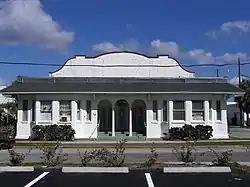 Punta Gorda Woman's Club |
April 5, 1991 (#91000382) |
118 Sullivan Street 26°56′06″N 82°03′08″W |
Punta Gorda | Part of the Punta Gorda MPS |
| 14 | H. W. Smith Building | 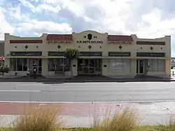 H. W. Smith Building |
July 25, 1991 (#91000894) |
121 East Marion Avenue 26°56′09″N 82°02′57″W |
Punta Gorda | Part of the Punta Gorda MPS |
| 15 | Villa Bianca | 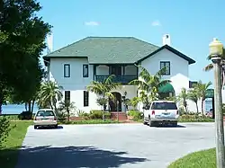 Villa Bianca |
November 28, 1990 (#90001760) |
2330 Shore Drive 26°57′01″N 82°01′24″W |
Punta Gorda | |
| 16 | West Coast Fish Company Residential Cabin at Bull Bay | April 11, 1991 (#91000401) |
Bull Bay north of Bull Key 26°46′33″N 82°12′14″W |
Placida | Part of the Fish Cabins of Charlotte Harbor MPS | |
| 17 | Willis Fish Cabin at Bull Bay |  Willis Fish Cabin at Bull Bay |
April 11, 1991 (#91000400) |
Bull Bay north of Bull Key 26°46′28″N 82°12′29″W |
Placida | Part of the Fish Cabins of Charlotte Harbor MPS |
See also
| Wikimedia Commons has media related to National Register of Historic Places in Charlotte County, Florida. |
References
- The latitude and longitude information provided in this table was derived originally from the National Register Information System, which has been found to be fairly accurate for about 99% of listings. Some locations in this table may have been corrected to current GPS standards.
- "National Register of Historic Places: Weekly List Actions". National Park Service, United States Department of the Interior. Retrieved on February 5, 2021.
- Numbers represent an alphabetical ordering by significant words. Various colorings, defined here, differentiate National Historic Landmarks and historic districts from other NRHP buildings, structures, sites or objects.
- "National Register Information System". National Register of Historic Places. National Park Service. March 13, 2009.
- The eight-digit number below each date is the number assigned to each location in the National Register Information System database, which can be viewed by clicking the number.
- Charlotte County History Collections
Municipalities and communities of Charlotte County, Florida, United States | ||
|---|---|---|
| City | | |
| CDPs | ||
| Unincorporated communities | ||
| Ghost town | ||
| Footnotes | ‡This populated place also has portions in an adjacent county or counties | |
| ||
This article is issued from Wikipedia. The text is licensed under Creative Commons - Attribution - Sharealike. Additional terms may apply for the media files.